Beecher Bible and Rifle Church

Log in to your account

AroundUs is a community-driven map of interesting places, built by curious explorers like you. It grows with every review, story, and photo you share.
Connect to save your favorite spots, contribute locations, and create personalized routes.
Continue with Google
Continue with Apple
Continue with X
Continue with Facebook
Continue with email
By continuing, you accept our Terms and Conditions and our Privacy Policy
Create an account
Add to collection
Map
Suggest a change
Share

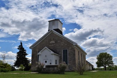
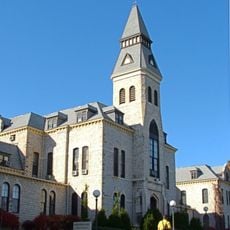
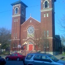
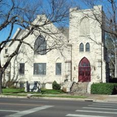
Beecher Bible and Rifle Church, Limestone church in Wabaunsee, United States

Beecher Bible and Rifle Church is a limestone building in Wabaunsee with a simple rectangular form, a gable roof, and a wooden bell tower. The structure shows typical features of rural 19th-century construction, with its central brick chimney visible from outside.

The church was founded in 1862 with support from Reverend Henry Ward Beecher, who sent firearms and religious materials to settlers resisting slavery in Kansas Territory. It stands as a testament to the territorial conflicts that shaped the region.

The building holds meaning for people interested in how religion and political conviction shaped frontier communities in Kansas. Walking through it, visitors sense the determination of those who gathered here for both spiritual and civic purposes.

Visitors can attend Sunday services or contact local representatives to arrange a guided tour of the building. The location at Chapel and Elm Streets makes it straightforward to find, and those who stop by can learn directly from people who know its story.

Reverend Beecher shipped rifles hidden in crates labeled as Bibles, creating the term 'Beecher's Bibles' during the Kansas conflicts. This resourceful approach allowed supporters of the anti-slavery cause to receive weapons while evading notice.

Location: Wabaunsee County

Inception: 1862

Architectural style: vernacular architecture

Floors above the ground: 1

Made from material: stone

Address: 31624 Chapel Street

GPS coordinates: 39.14444,-96.34556

Latest update: December 12, 2025 07:51

Photos
Around this place
Bill Snyder Family Football Stadium
United States of America

Bill Snyder Family Football Stadium

22.4 km
Johnny Kaw
United States of America

Johnny Kaw

20.1 km
World War I Memorial Stadium
United States of America

World War I Memorial Stadium

21.2 km
Konza Prairie
United States of America

Konza Prairie

19.3 km
Flint Hills Discovery Center
United States of America

Flint Hills Discovery Center

18.9 km
United States of America

Sunset Zoo

21.9 km
Hale Library
United States of America

Hale Library

20.9 km
Oz Museum
United States of America

Oz Museum

7.3 km
Anderson Hall
United States of America

Anderson Hall

20.9 km
Seven Dolors Catholic Church
United States of America

Seven Dolors Catholic Church

19.4 km
Seaton Hall
United States of America

Seaton Hall

21.1 km
Goodnow House
United States of America

Goodnow House

22.2 km
First Congregational Church
United States of America

First Congregational Church

19.6 km
Dickens Hall
United States of America

Dickens Hall

20.8 km
Manhattan Carnegie Library Building
United States of America

Manhattan Carnegie Library Building

19.3 km
Downtown Manhattan Historic District
United States of America

Downtown Manhattan Historic District

19 km
Paxico Historic District
United States of America

Paxico Historic District

17.6 km
Alma Downtown Historic District
United States of America

Alma Downtown Historic District

15.4 km
Jeremiah Platt House
United States of America

Jeremiah Platt House

21.7 km
E. A. and Ura Wharton House
United States of America

E. A. and Ura Wharton House

19.4 km
George and Virginia Trout House
United States of America

George and Virginia Trout House

7.5 km
Cassius & Adelia Baker House
United States of America

Cassius & Adelia Baker House

7.4 km
Bluemont Hall
United States of America

Bluemont Hall

20.8 km
Woman's Club House
United States of America

Woman's Club House

19.8 km
Cardwell Hall
United States of America

Cardwell Hall

21.1 km
Stuewe House
United States of America

Stuewe House

15.1 km
Hy-Vee
United States of America

Hy-Vee

19.1 km
Houston and Pierre Streets Residential Historic District
United States of America

Houston and Pierre Streets Residential Historic District

19.5 km
Show the full map
Reviews

Visited this place? Tap the stars to rate it and share your experience / photos with the community! Try now! You can cancel it anytime.

« Beecher Bible and Rifle Church - Limestone church in Wabaunsee, United States » is provided by Around Us (aroundus.com). Images and texts are derived from Wikimedia project under a Creative Commons license. You are allowed to copy, distribute, and modify copies of this page, under the conditions set by the license, as long as this note is clearly visible.

Discover hidden gems everywhere you go!

From secret cafés to breathtaking viewpoints, skip the crowded tourist spots and find places that match your style. Our app makes it easy with voice search, smart filtering, route optimization, and insider tips from travelers worldwide. Download now for the complete mobile experience.

Around Us App Screenshot

A unique approach to discovering new places

Le Figaro

All the places worth exploring

France Info

A tailor-made excursion in just a few clicks

20 Minutes