Enable Location

We need your location to show you interesting places around you

Discover nearby places

Find interesting locations and hidden gems around you

Precise directions

Get accurate directions and distances to places

Your location is never shared with other users. It's only used when you tap the location button.

Log in to your account

Start exploring — it's free

Trusted by 61,503 travelers worldwide

Continue with Google
Continue with Apple
or

We will send you a code to connect

By continuing, you accept our Terms and Conditions and our Privacy Policy

Check your inbox

We've sent a pincode in your inbox. Please enter the code below.

Bass River Recreation Area

Bass River Recreation Area, Natural recreation area in Ottawa County, Michigan

Description

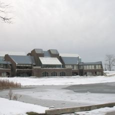
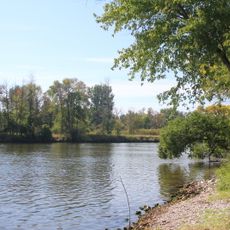
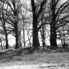
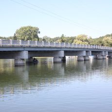
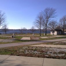
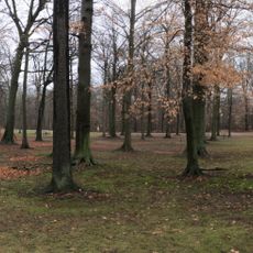
Bass River Recreation Area is a natural park in Ottawa County covering woodlands, meadows, and water bodies spread across a large area. The land features a major lake and sections of river frontage that shape the overall layout of the space.

History

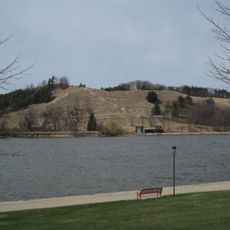
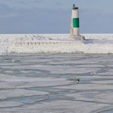
The area began as an industrial site in the 1900s that was later repurposed in the early 1990s into a recreation and nature area. This transformation turned the former working landscape into a place for outdoor activities and habitat restoration.

Culture

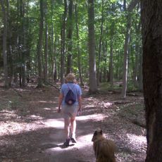
This place serves as a community outdoor destination where people come to experience nature across all seasons through walking and sport activities. The varied habitats from woodlands to water bodies create spaces where visitors can connect with the natural environment.

Practical

The area has multiple trailheads and routes accessible year-round for walking, biking, and skiing depending on the season. Visitors should be prepared for changing weather and ground conditions that shift with rainfall and winter snow.

Did you know?

The lakes and meadows here developed from old extraction pits where gravel was once removed for construction, now creating homes for birds and wildlife. This unexpected recovery demonstrates how former industrial sites can transform into thriving natural habitats.

Location
GPS coordinates
43.01340,-86.02740
Latest update
December 14, 2025 09:43

AroundUs brings together thousands of curated places, local tips, and hidden gems, enriched daily by 60,000 contributors worldwide. Discover all places nearby (Michigan).

Around this place
Grand Haven State Park
United States of America

Grand Haven State Park

18.4 km
Lubbers Stadium
United States of America

Lubbers Stadium

11.9 km
Pere Marquette 1223
United States of America

Pere Marquette 1223

17.6 km
Grand Haven Musical Fountain
United States of America

Grand Haven Musical Fountain

18.1 km
Grand Haven South Pierhead Inner Light
United States of America

Grand Haven South Pierhead Inner Light

19.1 km
Grand Haven South Pierhead Entrance Light
United States of America

Grand Haven South Pierhead Entrance Light

19.2 km
Coast Guard Station Grand Haven
United States of America

Coast Guard Station Grand Haven

18 km
Cook Carillon Tower
United States of America

Cook Carillon Tower

12.6 km
Kirkhof Center
United States of America

Kirkhof Center

12.6 km
Battle Point Site
United States of America

Battle Point Site

9.9 km
Grand Haven Historic District
United States of America

Grand Haven Historic District

17.7 km
Spoonville site
United States of America

Spoonville site

5.5 km
Grand Trunk Western Railroad Grand Haven Coal Tipple
United States of America

Grand Trunk Western Railroad Grand Haven Coal Tipple

17.6 km
Nathaniel and Esther Robbins House
United States of America

Nathaniel and Esther Robbins House

17.1 km
Edward P. Ferry House
United States of America

Edward P. Ferry House

17.1 km
Fruitport Road–Pettys Bayou Bridge
United States of America

Fruitport Road–Pettys Bayou Bridge

14.7 km
Aloys Bilz House
United States of America

Aloys Bilz House

15.7 km
Hudsonville Christian School Building
United States of America

Hudsonville Christian School Building

20.6 km
Olive Township District No. 1 School
United States of America

Olive Township District No. 1 School

9.3 km
Tri-Cities Historical Museum
United States of America

Tri-Cities Historical Museum

17.5 km
Tanglewood Park
United States of America

Tanglewood Park

15.7 km
Grand Haven 9
United States of America

Grand Haven 9

15.4 km
Pigeon Creek Park
United States of America

Pigeon Creek Park

10.4 km
Hager Park
United States of America

Hager Park

17.6 km
Grand Haven North Pierhead Light
United States of America

Grand Haven North Pierhead Light

19.3 km
The Escanaba Historical Marker
United States of America

The Escanaba Historical Marker

17.8 km
Lakeside Beach
United States of America

Lakeside Beach

14.9 km
VanSteeland Arboretum
United States of America

VanSteeland Arboretum

12.8 km
Show the full map
« Bass River Recreation Area - Natural recreation area in Ottawa County, Michigan » is provided by Around Us (aroundus.com). Images and texts are derived from Wikimedia project under a Creative Commons license. You are allowed to copy, distribute, and modify copies of this page, under the conditions set by the license, as long as this note is clearly visible.

Discover hidden gems everywhere you go!

From secret cafés to breathtaking viewpoints, skip the crowded tourist spots and find places that match your style. Our app makes it easy with voice search, smart filtering, route optimization, and insider tips from travelers worldwide. Download now for the complete mobile experience.

Around Us App Screenshot

A unique approach to discovering new places

Le Figaro

All the places worth exploring

France Info

A tailor-made excursion in just a few clicks

20 Minutes

Around Us
Travel Guide & Maps
Download

Send to your phone

QR Code
1

Open the camera app on your mobile.

2

Point at the QR code with your camera. A notification will appear.

3

Tap the notification to open the link.