Enable Location

We need your location to show you interesting places around you

Discover nearby places

Find interesting locations and hidden gems around you

Precise directions

Get accurate directions and distances to places

Your location is never shared with other users. It's only used when you tap the location button.

Fort Dobbs

Log in to your account

Start exploring — it's free

Trusted by 63,045 travelers worldwide

Continue with Google
Continue with Apple
or

We will send you a code to connect

By continuing, you accept our Terms and Conditions and our Privacy Policy

Check your inbox

We've sent a pincode in your inbox. Please enter the code below.

Discussion Reviews 1 Photos
13.3k Popularity

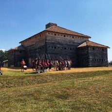
Fort Dobbs, Colonial fort in Statesville, United States.

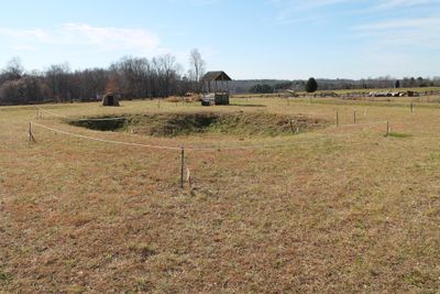
Fort Dobbs is a reconstructed colonial blockhouse with wooden log walls located near Statesville. The three-story structure features a shallow defensive ditch designed to protect against frontier threats.

The fort was built in 1755 under orders from Governor Arthur Dobbs to protect settlers during the French and Indian War. It existed as part of the larger colonial struggles that shaped the region's future.

The fort represents a meeting point where settlers and soldiers gathered to manage life on a contested frontier. Walking through the reconstruction, visitors see how people adapted their daily routines to defensive needs.

The site is reached via Fort Dobbs Road and can be explored on foot through grounds that are relatively level and easy to navigate. Inside and outside, visitors find exhibits and interpretive displays that explain the fort's role.

An engagement in February 1760 between Cherokee warriors and Provincial soldiers represents the only documented combat at the location. This skirmish remains a defining moment in the fort's operational history.

The community of curious travelers

AroundUs brings together thousands of curated places, local tips, and hidden gems, enriched daily by 60,000 contributors worldwide.

Start exploring
Location
Location
Province of North Carolina
Architects
Arthur Dobbs
GPS coordinates
35.82167,-80.89500
Latest update
December 7, 2025 20:40
Around this place
Lake Norman State Park
United States of America

Lake Norman State Park

17.6 km
Bunker Hill Covered Bridge
United States of America

Bunker Hill Covered Bridge

22.8 km
Allison Woods
United States of America

Allison Woods

10.6 km
A2 wind tunnel
United States of America

A2 wind tunnel

23.8 km
Iredell County Courthouse
United States of America

Iredell County Courthouse

4.3 km
Ebenezer Academy, Bethany Presbyterian Church and Cemetery
United States of America

Ebenezer Academy, Bethany Presbyterian Church and Cemetery

6.4 km
Congregation Emanuel
United States of America

Congregation Emanuel

4 km
St. Philip's Roman Catholic Church
United States of America

St. Philip's Roman Catholic Church

4.4 km
Daltonia
United States of America

Daltonia

23.9 km
Academy Hill Historic District
United States of America

Academy Hill Historic District

5 km
Morrison-Mott House
United States of America

Morrison-Mott House

3.6 km
Center Street A.M.E. Zion Church
United States of America

Center Street A.M.E. Zion Church

4.8 km
Damascus Baptist Church Arbor
United States of America

Damascus Baptist Church Arbor

14.6 km
United States Post Office and County Courthouse
United States of America

United States Post Office and County Courthouse

4.4 km
Col. Silas Alexander Sharpe House
United States of America

Col. Silas Alexander Sharpe House

4.5 km
Snow Creek Methodist Church and Burying Ground
United States of America

Snow Creek Methodist Church and Burying Ground

10.1 km
Christ Episcopal Church
United States of America

Christ Episcopal Church

23 km
Murray's Mill Historic Site
United States of America

Murray's Mill Historic Site

24.2 km
Main Building, Mitchell College
United States of America

Main Building, Mitchell College

4.3 km
Bethesda Presbyterian Church
United States of America

Bethesda Presbyterian Church

13.8 km
East Broad Street-Davie Avenue Historic District
United States of America

East Broad Street-Davie Avenue Historic District

3.9 km
South Race Street Historic District
United States of America

South Race Street Historic District

4.2 km
Statesville Commercial Historic District
United States of America

Statesville Commercial Historic District

4.2 km
McElwee Houses
United States of America

McElwee Houses

4 km
Rankin-Sherrill House
United States of America

Rankin-Sherrill House

23.7 km
John Carlyle and Anita Sherrill House
United States of America

John Carlyle and Anita Sherrill House

23.7 km
Fort Dobbs State Historic Site
United States of America

Fort Dobbs State Historic Site

214 m
Lucas Mansion
United States of America

Lucas Mansion

20.1 km
Show the full map
Reviews
Share your experience

No review yet

Discussions
Start a discussion...

No discussion yet

« Fort Dobbs - Colonial fort in Statesville, United States » is provided by Around Us (aroundus.com). Images and texts are derived from Wikimedia project under a Creative Commons license. You are allowed to copy, distribute, and modify copies of this page, under the conditions set by the license, as long as this note is clearly visible.

Discover hidden gems everywhere you go!

From secret cafés to breathtaking viewpoints, skip the crowded tourist spots and find places that match your style. Our app makes it easy with voice search, smart filtering, route optimization, and insider tips from travelers worldwide. Download now for the complete mobile experience.

Around Us App Screenshot

A unique approach to discovering new places

Le Figaro

All the places worth exploring

France Info

A tailor-made excursion in just a few clicks

20 Minutes

Around Us
Travel Guide & Maps
Download

Send to your phone

QR Code
1

Open the camera app on your mobile.

2

Point at the QR code with your camera. A notification will appear.

3

Tap the notification to open the link.