Enable Location

We need your location to show you interesting places around you

Discover nearby places

Find interesting locations and hidden gems around you

Precise directions

Get accurate directions and distances to places

Your location is never shared with other users. It's only used when you tap the location button.

Big Hill Lake

Log in to your account

Start exploring — it's free

Trusted by 62,558 travelers worldwide

Continue with Google
Continue with Apple
or

We will send you a code to connect

By continuing, you accept our Terms and Conditions and our Privacy Policy

Check your inbox

We've sent a pincode in your inbox. Please enter the code below.

Big Hill Lake

Big Hill Lake, near Parsons, Kansas, United States

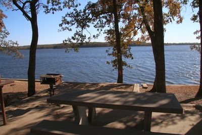
Big Hill Lake is a reservoir located along the border between Montgomery County and Labette County in southeastern Kansas. The water body covers about 1,200 acres and contains sandy beaches, rocky shorelines, and submerged trees that create underwater structures where fish gather.

The lake was constructed by the Army Corps of Engineers primarily for recreation and water management in the region. Since its creation, it has become an important leisure destination and fishing ground for the local community.

The lake takes its name from the nearby Big Hill elevation. You can observe how locals use the space: fishing with family, relaxing at picnic areas, and swimming during summer months when the water becomes a gathering place for the community.

The lake is located about 4 and a half miles east of Cherryvale and offers camping areas with and without electrical hookups, picnic zones, and boat launch facilities. Early morning and late evening are the best times to visit, especially for fishing when fish are most active.

The lake reaches depths of about 60 feet, creating distinct zones where different fish species prefer to gather at different depths and conditions. This depth variation makes different parts of the lake suitable for anglers of different skill levels and fishing methods.

The community of curious travelers

AroundUs brings together thousands of curated places, local tips, and hidden gems, enriched daily by 60,000 contributors worldwide.

Start exploring
Location
GPS coordinates
37.28660,-95.45810
Latest update
February 9, 2026 08:24
Around this place
Big Brutus
United States of America

Big Brutus

46 km
Elk City State Park
United States of America

Elk City State Park

27.9 km
Norman No. 1 Oil Well
United States of America

Norman No. 1 Oil Well

23.8 km
Independence Public Library
United States of America

Independence Public Library

23 km
Oswego Public Library
United States of America

Oswego Public Library

33.8 km
Girard Public Library
United States of America

Girard Public Library

59.7 km
Booth Theater
United States of America

Booth Theater

23 km
Onion Creek Bridge (Coffeyville, Kansas)
United States of America

Onion Creek Bridge (Coffeyville, Kansas)

33.9 km
Booth Hotel
United States of America

Booth Hotel

23.3 km
Gold Dust Hotel
United States of America

Gold Dust Hotel

42.6 km
Brown Hotel
United States of America

Brown Hotel

24.5 km
Carnegie Library
United States of America

Carnegie Library

18.4 km
Bethel African Methodist Episcopal Church
United States of America

Bethel African Methodist Episcopal Church

31.6 km
Niotaze Methodist Episcopal Church
United States of America

Niotaze Methodist Episcopal Church

55 km
Coffeyville Carnegie Public Library Building
United States of America

Coffeyville Carnegie Public Library Building

31.5 km
St. John's Episcopal Church
United States of America

St. John's Episcopal Church

59.7 km
Little House On The Prairie Museum
United States of America

Little House On The Prairie Museum

38.1 km
Columbus Public Carnegie Library
United States of America

Columbus Public Carnegie Library

55.9 km
City Square Park Bandstand
United States of America

City Square Park Bandstand

58.4 km
Lander's Wagon and Carriage Shop
United States of America

Lander's Wagon and Carriage Shop

58.4 km
State Street Bridge
United States of America

State Street Bridge

37.2 km
Brush Creek Bridge
United States of America

Brush Creek Bridge

58.3 km
Murray High School
United States of America

Murray High School

43.6 km
Martin and Osa Johnson Safari Museum
United States of America

Martin and Osa Johnson Safari Museum

44.1 km
Curious Minds Discovery Zone
United States of America

Curious Minds Discovery Zone

17.5 km
Dewlen-Spohnhauer Bridge
United States of America

Dewlen-Spohnhauer Bridge

20.7 km
Independence Historical Museum & Art Center
United States of America

Independence Historical Museum & Art Center

23.2 km
Independence Downtown Historic District
United States of America

Independence Downtown Historic District

22.9 km
Show the full map
« Big Hill Lake - near Parsons, Kansas, United States » is provided by Around Us (aroundus.com). Images and texts are derived from Wikimedia project under a Creative Commons license. You are allowed to copy, distribute, and modify copies of this page, under the conditions set by the license, as long as this note is clearly visible.

Discover hidden gems everywhere you go!

From secret cafés to breathtaking viewpoints, skip the crowded tourist spots and find places that match your style. Our app makes it easy with voice search, smart filtering, route optimization, and insider tips from travelers worldwide. Download now for the complete mobile experience.

Around Us App Screenshot

A unique approach to discovering new places

Le Figaro

All the places worth exploring

France Info

A tailor-made excursion in just a few clicks

20 Minutes

Around Us
Travel Guide & Maps
Download

Send to your phone

QR Code
1

Open the camera app on your mobile.

2

Point at the QR code with your camera. A notification will appear.

3

Tap the notification to open the link.