Enable Location

We need your location to show you interesting places around you

Discover nearby places

Find interesting locations and hidden gems around you

Precise directions

Get accurate directions and distances to places

Your location is never shared with other users. It's only used when you tap the location button.

Brubaker Covered Bridge

Log in to your account

Start exploring — it's free

Trusted by 61,868 travelers worldwide

Continue with Google
Continue with Apple
or

We will send you a code to connect

By continuing, you accept our Terms and Conditions and our Privacy Policy

Check your inbox

We've sent a pincode in your inbox. Please enter the code below.

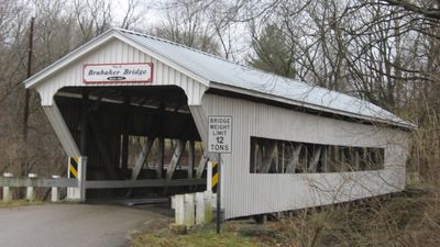
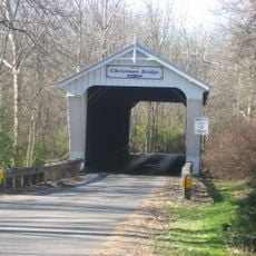
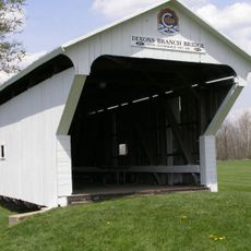
Brubaker Covered Bridge, Wooden covered bridge near Gratis, United States.

Description

Brubaker Covered Bridge is a wooden structure spanning Sandy Run in Ohio with a single-span design. The bridge measures about 85 feet (26 meters) and uses a Childs truss system with wooden walls and a gabled roof.

History

The bridge was built in 1887 by architect Everett S. Sherman and listed on the National Register of Historic Places in June 1975. Its construction reflects late 1800s engineering approaches used for river crossings in the region.

Culture

The bridge represents nineteenth-century engineering methods in Ohio, demonstrating the period's transportation infrastructure development and construction techniques.

Practical

This bridge is accessible year-round via Aukerman Creek Road in Preble County. The structure requires careful footing, especially when wet, and visitors should move through with attention to their step.

Did you know?

The Childs truss design of this bridge incorporates specific structural elements that distribute weight loads effectively across its wooden frame components.

Location
Architects
Everett S. Sherman
GPS coordinates
39.65170,-84.54420
Latest update
December 14, 2025 15:02

AroundUs brings together thousands of curated places, local tips, and hidden gems, enriched daily by 60,000 contributors worldwide. Discover all places nearby (Ohio).

Around this place
Hueston Woods State Park
United States of America

Hueston Woods State Park

19.2 km
Great Mound
United States of America

Great Mound

16.2 km
Roberts Covered Bridge
United States of America

Roberts Covered Bridge

12.8 km
Zachariah Price Dewitt Cabin
United States of America

Zachariah Price Dewitt Cabin

21.7 km
Pugh's Mill Covered Bridge
United States of America

Pugh's Mill Covered Bridge

21.7 km
John B. Tytus House
United States of America

John B. Tytus House

19.3 km
Christman Covered Bridge
United States of America

Christman Covered Bridge

16.3 km
Hopewell Associate Reformed Presbyterian Church
United States of America

Hopewell Associate Reformed Presbyterian Church

19.3 km
Mann Mound
United States of America

Mann Mound

11.9 km
South Main Street District
United States of America

South Main Street District

19.3 km
Germantown Covered Bridge
United States of America

Germantown Covered Bridge

15.6 km
Acton House
United States of America

Acton House

13 km
Matthew Hueston House
United States of America

Matthew Hueston House

21.3 km
Market Square (Miamisburg, Ohio)
United States of America

Market Square (Miamisburg, Ohio)

20.9 km
Emmanuel's Evangelical Lutheran Church
United States of America

Emmanuel's Evangelical Lutheran Church

15 km
Harshman Covered Bridge
United States of America

Harshman Covered Bridge

20.1 km
John Augspurger Farm No. 2
United States of America

John Augspurger Farm No. 2

21.7 km
Austin-Magie Farm and Mill District
United States of America

Austin-Magie Farm and Mill District

21.4 km
Christian Ehresman Farm
United States of America

Christian Ehresman Farm

21.7 km
Unzicker-Cook House
United States of America

Unzicker-Cook House

16.2 km
Preble County Historical Society and Nature Reserve
United States of America

Preble County Historical Society and Nature Reserve

739 m
Great Miami River Recreation Trail
United States of America

Great Miami River Recreation Trail

18.8 km
By-Jo Theatre
United States of America

By-Jo Theatre

15.2 km
Hunting Lodge Farm
United States of America

Hunting Lodge Farm

21.1 km
Dixon's Branch Bridge
United States of America

Dixon's Branch Bridge

21.6 km
Saint Clair Street Bridge
United States of America

Saint Clair Street Bridge

12.7 km
The Canal Museum
United States of America

The Canal Museum

19.2 km
Roberts Bridge
United States of America

Roberts Bridge

12.8 km
Show the full map
« Brubaker Covered Bridge - Wooden covered bridge near Gratis, United States » is provided by Around Us (aroundus.com). Images and texts are derived from Wikimedia project under a Creative Commons license. You are allowed to copy, distribute, and modify copies of this page, under the conditions set by the license, as long as this note is clearly visible.

Discover hidden gems everywhere you go!

From secret cafés to breathtaking viewpoints, skip the crowded tourist spots and find places that match your style. Our app makes it easy with voice search, smart filtering, route optimization, and insider tips from travelers worldwide. Download now for the complete mobile experience.

Around Us App Screenshot

A unique approach to discovering new places

Le Figaro

All the places worth exploring

France Info

A tailor-made excursion in just a few clicks

20 Minutes

Around Us
Travel Guide & Maps
Download

Send to your phone

QR Code
1

Open the camera app on your mobile.

2

Point at the QR code with your camera. A notification will appear.

3

Tap the notification to open the link.