Enable Location

We need your location to show you interesting places around you

Discover nearby places

Find interesting locations and hidden gems around you

Precise directions

Get accurate directions and distances to places

Your location is never shared with other users. It's only used when you tap the location button.

Calf Pasture Pumping Station Complex

Log in to your account

Start exploring — it's free

Trusted by 62,537 travelers worldwide

Continue with Google
Continue with Apple
or

We will send you a code to connect

By continuing, you accept our Terms and Conditions and our Privacy Policy

Check your inbox

We've sent a pincode in your inbox. Please enter the code below.

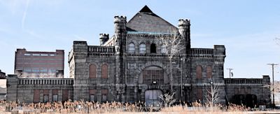
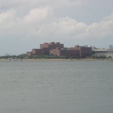
Calf Pasture Pumping Station Complex, Sewerage pumping station in Dorchester, Boston, United States

The Calf Pasture Pumping Station Complex sits at 435 Mount Vernon Street in Dorchester with Richardsonian Romanesque architectural features designed by George Clough. The 9.5-acre site encompasses the structures that formed Boston's first sewage treatment facility in the 1800s.

The facility was built in 1883 as Boston's first sewage treatment station and operated until 1968 when operations shifted to the Deer Island facility. This closure marked the end of wastewater handling at the original location.

The name traces back to its original use as pastureland for calves in the 1600s, a past that still echoes in the site's identity today. This transformation reflects how urban spaces shifted from rural functions to industrial purposes over centuries.

The site is currently managed by the University of Massachusetts Building Authority, which reviews development proposals for future uses. Visitors should expect that access may be limited depending on ongoing projects and preservation work at the complex.

The pumping station is the only surviving 19th-century structure on Columbia Point and channeled waste to a treatment facility on Moon Island in Boston Harbor. The connection to an island with such an unusual name adds an unexpected historical detail to Boston's past.

The community of curious travelers

AroundUs brings together thousands of curated places, local tips, and hidden gems, enriched daily by 60,000 contributors worldwide.

Start exploring
Location
GPS coordinates
42.31333,-71.03361
Latest update
December 12, 2025 14:22
Around this place
John F. Kennedy Presidential Library and Museum
United States of America

John F. Kennedy Presidential Library and Museum

38 m
James Blake House
United States of America

James Blake House

2.3 km
United States of America

Strand Theatre

2.7 km
Squantum Point Park
United States of America

Squantum Point Park

1.5 km
Shirley-Eustis House
United States of America

Shirley-Eustis House

3.4 km
Statue of David Farragut
United States of America

Statue of David Farragut

2.6 km
Monan Park
United States of America

Monan Park

772 m
Dorchester North Burying Ground
United States of America

Dorchester North Burying Ground

2.5 km
Pierce House
United States of America

Pierce House

3.4 km
William Monroe Trotter House
United States of America

William Monroe Trotter House

2.4 km
Cathedral of St. George Historic District
United States of America

Cathedral of St. George Historic District

2.6 km
Statue of Edward Everett
United States of America

Statue of Edward Everett

2.3 km
Fort Independence
United States of America

Fort Independence

3.3 km
Captain Lemuel Clap House
United States of America

Captain Lemuel Clap House

2.1 km
Clapp Houses
United States of America

Clapp Houses

2.1 km
William Clapp House
United States of America

William Clapp House

2.1 km
Harrison Loring House
United States of America

Harrison Loring House

2.5 km
Upham's Corner Market
United States of America

Upham's Corner Market

2.6 km
Pilgrim Congregational Church
United States of America

Pilgrim Congregational Church

2.8 km
John R. Nelson House
United States of America

John R. Nelson House

2.7 km
United States of America

Old Harbor Reservation Parkways

2.1 km
Fields Corner Municipal Building
United States of America

Fields Corner Municipal Building

2.5 km
Intervale Street-Columbia Road Historic District
United States of America

Intervale Street-Columbia Road Historic District

3.5 km
South Boston Boat Clubs Historic District
United States of America

South Boston Boat Clubs Historic District

3.2 km
Glover House
United States of America

Glover House

3.4 km
Columbia Road–Bellevue Street Historic District
United States of America

Columbia Road–Bellevue Street Historic District

2.9 km
Clipper Ship Monument to Donald McKay
United States of America

Clipper Ship Monument to Donald McKay

3.5 km
Massachusetts Archives & Commonwealth Museum
United States of America

Massachusetts Archives & Commonwealth Museum

122 m
Show the full map
« Calf Pasture Pumping Station Complex - Sewerage pumping station in Dorchester, Boston, United States » is provided by Around Us (aroundus.com). Images and texts are derived from Wikimedia project under a Creative Commons license. You are allowed to copy, distribute, and modify copies of this page, under the conditions set by the license, as long as this note is clearly visible.

Discover hidden gems everywhere you go!

From secret cafés to breathtaking viewpoints, skip the crowded tourist spots and find places that match your style. Our app makes it easy with voice search, smart filtering, route optimization, and insider tips from travelers worldwide. Download now for the complete mobile experience.

Around Us App Screenshot

A unique approach to discovering new places

Le Figaro

All the places worth exploring

France Info

A tailor-made excursion in just a few clicks

20 Minutes

Around Us
Travel Guide & Maps
Download

Send to your phone

QR Code
1

Open the camera app on your mobile.

2

Point at the QR code with your camera. A notification will appear.

3

Tap the notification to open the link.