Enable Location

We need your location to show you interesting places around you

Discover nearby places

Find interesting locations and hidden gems around you

Precise directions

Get accurate directions and distances to places

Your location is never shared with other users. It's only used when you tap the location button.

Calfee Park

Log in to your account

Start exploring — it's free

Trusted by 62,561 travelers worldwide

Continue with Google
Continue with Apple
or

We will send you a code to connect

By continuing, you accept our Terms and Conditions and our Privacy Policy

Check your inbox

We've sent a pincode in your inbox. Please enter the code below.

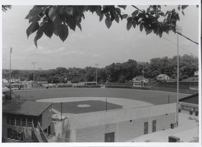
Calfee Park, Baseball stadium in Pulaski, Virginia, U.S.

Calfee Park is a baseball stadium in Pulaski, Virginia, built in 1935 and marked by its classic layout. The venue features a grass field, stands around the perimeter, and holds about 3,200 people, with distances of 338 feet in left field and 405 feet in center field.

The stadium was built in 1935 with support from the Works Progress Administration, a government program during the Great Depression. Since opening, the park has hosted dozens of baseball teams and was added to the National Register of Historic Places in 1999.

The park is named after Ernest W. Calfee, a former mayor of Pulaski, reflecting local history through its name. Visitors can see how this place remains a gathering point for the community, where people come together to watch baseball and strengthen local bonds.

The venue is easy to reach from downtown Pulaski and provides parking for visitors. The space is accessible and allows you to watch games comfortably from the stands or on the grass.

The stadium has been featured in several magazines including Sports Illustrated and National Geographic. Fans voted it the best rookie-level ballpark in the US in 2019 and 2020.

The community of curious travelers

AroundUs brings together thousands of curated places, local tips, and hidden gems, enriched daily by 60,000 contributors worldwide.

Start exploring
Location
Inception
1935
Official opening
1935
Capacity
2500
GPS coordinates
37.03931,-80.77556
Latest update
February 7, 2026 11:00
Around this place
Claytor Lake
United States of America

Claytor Lake

10.3 km
New River Trail State Park
United States of America

New River Trail State Park

18.5 km
Claytor Lake State Park
United States of America

Claytor Lake State Park

13.3 km
The Mansion at Fort Chiswell
United States of America

The Mansion at Fort Chiswell

17.8 km
Shot Tower Historical State Park
United States of America

Shot Tower Historical State Park

18.6 km
Claytor Dam
United States of America

Claytor Dam

17.4 km
Foster Falls Historic District
United States of America

Foster Falls Historic District

18.7 km
Graham's Forge Mill
United States of America

Graham's Forge Mill

14.6 km
Back Creek Farm
United States of America

Back Creek Farm

15.3 km
Haven B. Howe House
United States of America

Haven B. Howe House

12.4 km
Ingles Bottom Archeological Sites
United States of America

Ingles Bottom Archeological Sites

18.5 km
Fairview District Home
United States of America

Fairview District Home

8 km
Rockwood
United States of America

Rockwood

10.5 km
Walker's Creek Presbyterian Church
United States of America

Walker's Creek Presbyterian Church

18.1 km
Maj. David Graham House
United States of America

Maj. David Graham House

16.2 km
Pulaski Historic Residential District
United States of America

Pulaski Historic Residential District

1.6 km
Pulaski Historic Commercial District
United States of America

Pulaski Historic Commercial District

8.4 km
Pulaski County Courthouse
United States of America

Pulaski County Courthouse

1.1 km
Dalton Theater
United States of America

Dalton Theater

899 m
New Dublin Presbyterian Church
United States of America

New Dublin Presbyterian Church

12 km
Newbern Historic District
United States of America

Newbern Historic District

8.4 km
Dublin Historic District
United States of America

Dublin Historic District

11 km
Spring Dale (Dublin, Virginia)
United States of America

Spring Dale (Dublin, Virginia)

15.8 km
Belle-Hampton
United States of America

Belle-Hampton

18.5 km
La Riviere
United States of America

La Riviere

18.2 km
Pulaski South Historic Residential and Industrial District
United States of America

Pulaski South Historic Residential and Industrial District

866 m
Grayson-Gravely House
United States of America

Grayson-Gravely House

18.9 km
Ingles Ferry
United States of America

Ingles Ferry

18.6 km
Show the full map
« Calfee Park - Baseball stadium in Pulaski, Virginia, U.S » is provided by Around Us (aroundus.com). Images and texts are derived from Wikimedia project under a Creative Commons license. You are allowed to copy, distribute, and modify copies of this page, under the conditions set by the license, as long as this note is clearly visible.

Discover hidden gems everywhere you go!

From secret cafés to breathtaking viewpoints, skip the crowded tourist spots and find places that match your style. Our app makes it easy with voice search, smart filtering, route optimization, and insider tips from travelers worldwide. Download now for the complete mobile experience.

Around Us App Screenshot

A unique approach to discovering new places

Le Figaro

All the places worth exploring

France Info

A tailor-made excursion in just a few clicks

20 Minutes

Around Us
Travel Guide & Maps
Download

Send to your phone

QR Code
1

Open the camera app on your mobile.

2

Point at the QR code with your camera. A notification will appear.

3

Tap the notification to open the link.