Enable Location

We need your location to show you interesting places around you

Discover nearby places

Find interesting locations and hidden gems around you

Precise directions

Get accurate directions and distances to places

Your location is never shared with other users. It's only used when you tap the location button.

Cabin Run Covered Bridge

Log in to your account

Start exploring — it's free

Trusted by 62,331 travelers worldwide

Continue with Google
Continue with Apple
or

We will send you a code to connect

By continuing, you accept our Terms and Conditions and our Privacy Policy

Check your inbox

We've sent a pincode in your inbox. Please enter the code below.

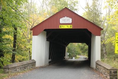
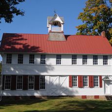
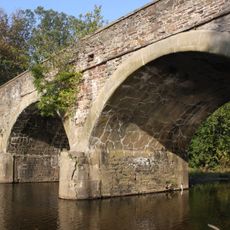
Cabin Run Covered Bridge, covered bridge crossing Cabin Run, Bucks County, Pennsylvania

Cabin Run Covered Bridge is a wooden bridge built in 1871 in Bucks County, Pennsylvania, spanning Cabin Run Creek. About 82 feet (25 meters) long and 15 feet (4.5 meters) wide, it features vertical wooden boards on its sides, a diagonally laid deck, and an open roof design that creates a sheltered passage through its dark interior.

Built by David Sutton in 1871 using wooden trusses designed to last, the bridge was listed on the National Register of Historic Places in 1980. Its survival over more than 150 years reflects the durability of 19th-century rural construction methods and the importance of such crossings to early settlement patterns.

The bridge takes its name from Cabin Run Creek, named after log cabins that once stood in the area. The simple wooden structure with its open sides reflects how rural communities built practical crossings that served both daily travel and local commerce.

The bridge sits near Ralph Stover State Park and can be found by turning onto Schletz Hill Road from Stump Road, about 0.7 miles from the intersection. It welcomes foot traffic easily, though parking is limited nearby, so using the Stover-Myers Mill County Park lot makes access more convenient.

The area around the bridge was once home to the Doane Boys, a notorious group of Tory outlaws active during the American Revolution who lived nearby. This hidden local history adds intrigue to the spot, as visitors walking through often overlook this connection to the region's turbulent past.

The community of curious travelers

AroundUs brings together thousands of curated places, local tips, and hidden gems, enriched daily by 60,000 contributors worldwide.

Start exploring
Location
GPS coordinates
40.24250,-75.11250
Latest update
February 9, 2026 07:43
Around this place
Mercer Museum
United States of America

Mercer Museum

7.4 km
Fisher House
United States of America

Fisher House

8.4 km
James A. Michener Art Museum
United States of America

James A. Michener Art Museum

7.4 km
Graeme Park
United States of America

Graeme Park

4.3 km
Oscar Hammerstein II Farm
United States of America

Oscar Hammerstein II Farm

7.5 km
Power Line Trail
United States of America

Power Line Trail

7.4 km
Moland House
United States of America

Moland House

1.8 km
Fordhook Farm
United States of America

Fordhook Farm

6.9 km
The Fountain House
United States of America

The Fountain House

7.7 km
Kids Castle
United States of America

Kids Castle

5.3 km
Fonthill, Mercer Museum and Moravian Pottery and Tile Works
United States of America

Fonthill, Mercer Museum and Moravian Pottery and Tile Works

8.4 km
Craven Hall
United States of America

Craven Hall

6.6 km
Pugh Dungan House
United States of America

Pugh Dungan House

7.7 km
Bridge Valley Bridge
United States of America

Bridge Valley Bridge

4.5 km
Doylestown Historic District
United States of America

Doylestown Historic District

7.8 km
Horsham Friends Meeting
United States of America

Horsham Friends Meeting

6.8 km
Tabor Home for Needy and Destitute Children
United States of America

Tabor Home for Needy and Destitute Children

5.7 km
Henry Schmieder Arboretum
United States of America

Henry Schmieder Arboretum

7.4 km
Ivyland Historic District
United States of America

Ivyland Historic District

5 km
Union Library Company
United States of America

Union Library Company

7.5 km
Forest Grove Historic District
United States of America

Forest Grove Historic District

7.1 km
Fretz Farm
United States of America

Fretz Farm

3.4 km
Kenderdine Mill Complex
United States of America

Kenderdine Mill Complex

6.2 km
Horsham–Montgomery Bridge
United States of America

Horsham–Montgomery Bridge

6.8 km
Shaw Historic District
United States of America

Shaw Historic District

7.8 km
County Theater
United States of America

County Theater

7.7 km
James-Lorah House
United States of America

James-Lorah House

8 km
Haus für Familie Norman Fisher
United States of America

Haus für Familie Norman Fisher

8.4 km
Show the full map
« Cabin Run Covered Bridge - covered bridge crossing Cabin Run, Bucks County, Pennsylvania » is provided by Around Us (aroundus.com). Images and texts are derived from Wikimedia project under a Creative Commons license. You are allowed to copy, distribute, and modify copies of this page, under the conditions set by the license, as long as this note is clearly visible.

Discover hidden gems everywhere you go!

From secret cafés to breathtaking viewpoints, skip the crowded tourist spots and find places that match your style. Our app makes it easy with voice search, smart filtering, route optimization, and insider tips from travelers worldwide. Download now for the complete mobile experience.

Around Us App Screenshot

A unique approach to discovering new places

Le Figaro

All the places worth exploring

France Info

A tailor-made excursion in just a few clicks

20 Minutes

Around Us
Travel Guide & Maps
Download

Send to your phone

QR Code
1

Open the camera app on your mobile.

2

Point at the QR code with your camera. A notification will appear.

3

Tap the notification to open the link.