Enable Location

We need your location to show you interesting places around you

Discover nearby places

Find interesting locations and hidden gems around you

Precise directions

Get accurate directions and distances to places

Your location is never shared with other users. It's only used when you tap the location button.

Carl Schurz Park

Log in to your account

Start exploring — it's free

Trusted by 62,562 travelers worldwide

Continue with Google
Continue with Apple
or

We will send you a code to connect

By continuing, you accept our Terms and Conditions and our Privacy Policy

Check your inbox

We've sent a pincode in your inbox. Please enter the code below.

Carl Schurz Park

Carl Schurz Park, Public park in Yorkville, Manhattan, United States.

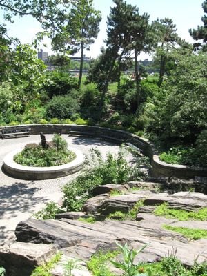
Carl Schurz Park is a green space of about 15 acres along the East River with winding paths, lawns, and waterfront areas. It includes gardens, two dog runs, basketball courts, and a large children's playground that serve both residents and visitors.

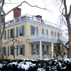
The site was known as Hoorn's Hook and held military importance during the Revolutionary War before Archibald Gracie built his mansion there in 1799. The location eventually became a public park and has housed the mayor's official residence since 1942.

Gracie Mansion, the official residence of New York City's mayors, sits within the park and shapes how locals view this space as a civic landmark. The presence of this building connects the park to the city's political life in a tangible way.

The park sits directly along the East River with easy access to waterfront paths and river views. Most areas are flat and walkable, though visitors will encounter stairs in certain spots.

The waterfront promenade sits on an elevated platform built directly over the Franklin D. Roosevelt East River Drive, creating an unusual connection to the river. This design allows pedestrians to walk along the water while a busy road runs underneath.

The community of curious travelers

AroundUs brings together thousands of curated places, local tips, and hidden gems, enriched daily by 60,000 contributors worldwide.

Start exploring
Location
GPS coordinates
40.77528,-73.94361
Latest update
December 7, 2025 19:27
Around this place
Gracie Mansion
United States of America

Gracie Mansion

104 m
The Octagon
United States of America

The Octagon

699 m
Noguchi Museum
United States of America

Noguchi Museum

1.1 km
Blackwell Island Light
United States of America

Blackwell Island Light

402 m
United States of America

Museum of Motherhood

531 m
Temple Shaaray Tefila
United States of America

Temple Shaaray Tefila

1 km
John Jay Park
United States of America

John Jay Park

826 m
Sohmer and Company Piano Factory
United States of America

Sohmer and Company Piano Factory

957 m
Hungarian House of New York
United States of America

Hungarian House of New York

974 m
The Noguchi Museum
United States of America

The Noguchi Museum

1.1 km
Holy Trinity Church, St. Christopher House and Parsonage
United States of America

Holy Trinity Church, St. Christopher House and Parsonage

608 m
Yorkville Bank Building
United States of America

Yorkville Bank Building

930 m
Stevens House
United States of America

Stevens House

904 m
John Jay Swimming Pool
United States of America

John Jay Swimming Pool

792 m
Distrito histórico City and Suburban Homes Company's York Avenue Estate and Shively Sanitary Tenements
United States of America

Distrito histórico City and Suburban Homes Company's York Avenue Estate and Shively Sanitary Tenements

758 m
Henderson Place Historic District
United States of America

Henderson Place Historic District

117 m
Municipal Asphalt Plant
United States of America

Municipal Asphalt Plant

328 m
The Monarch, 200 East 89th Street
United States of America

The Monarch, 200 East 89th Street

936 m
AMC Loews Orpheum 7
United States of America

AMC Loews Orpheum 7

997 m
Astor Terrace
United States of America

Astor Terrace

931 m
RiverEast, 408 East 92nd Street
United States of America

RiverEast, 408 East 92nd Street

613 m
200 East 90th Street
United States of America

200 East 90th Street

953 m
300 East 93rd Street
United States of America

300 East 93rd Street

841 m
The Ventura
United States of America

The Ventura

813 m
1802 Second Avenue
United States of America

1802 Second Avenue

886 m
1558 Third Avenue
United States of America

1558 Third Avenue

984 m
The Barclay
United States of America

The Barclay

485 m
302 East 94th Street
United States of America

302 East 94th Street

903 m
Show the full map
« Carl Schurz Park - Public park in Yorkville, Manhattan, United States » is provided by Around Us (aroundus.com). Images and texts are derived from Wikimedia project under a Creative Commons license. You are allowed to copy, distribute, and modify copies of this page, under the conditions set by the license, as long as this note is clearly visible.

Discover hidden gems everywhere you go!

From secret cafés to breathtaking viewpoints, skip the crowded tourist spots and find places that match your style. Our app makes it easy with voice search, smart filtering, route optimization, and insider tips from travelers worldwide. Download now for the complete mobile experience.

Around Us App Screenshot

A unique approach to discovering new places

Le Figaro

All the places worth exploring

France Info

A tailor-made excursion in just a few clicks

20 Minutes

Around Us
Travel Guide & Maps
Download

Send to your phone

QR Code
1

Open the camera app on your mobile.

2

Point at the QR code with your camera. A notification will appear.

3

Tap the notification to open the link.