Enable Location

We need your location to show you interesting places around you

Discover nearby places

Find interesting locations and hidden gems around you

Precise directions

Get accurate directions and distances to places

Your location is never shared with other users. It's only used when you tap the location button.

Carroll Building

Log in to your account

Start exploring — it's free

Trusted by 63,368 travelers worldwide

Continue with Google
Continue with Apple
or

We will send you a code to connect

By continuing, you accept our Terms and Conditions and our Privacy Policy

Check your inbox

We've sent a pincode in your inbox. Please enter the code below.

Discussion Reviews 1 Photos
1.2k Popularity

Carroll Building, Historic commercial building in Hartford, Connecticut.

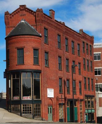
Carroll Building is a historic commercial structure located at the intersection of Farmington Avenue and Asylum Avenue in Hartford. It features early 20th-century architectural details and maintains its original facade from the time of its construction.

Architect Stephen C. Earle designed this structure during Hartford's period of significant commercial growth in the early 1900s. Its completion marked an important phase in the city's expansion and development.

The building represents an important example of commercial architecture that influenced the development patterns of Hartford's urban landscape through the decades.

The building is easily accessible and located at a convenient intersection in downtown Hartford. Visitors can view the exterior from the street and observe its architectural features from the surrounding area.

The building sits at a crossroads point that marks boundaries between different sections of the city. This location made it a natural visual landmark for navigation in Hartford's historic commercial district.

The community of curious travelers

AroundUs brings together thousands of curated places, local tips, and hidden gems, enriched daily by 60,000 contributors worldwide.

Start exploring
Location
Architects
Stephen C. Earle
GPS coordinates
41.52433,-72.07961
Latest update
December 14, 2025 18:46
Around this place
American Thermos Bottle Company Laurel Hill Plant
United States of America

American Thermos Bottle Company Laurel Hill Plant

1.6 km
Leffingwell Inn
United States of America

Leffingwell Inn

2.1 km
Norwich Town Hall
United States of America

Norwich Town Hall

279 m
Nathaniel Backus House
United States of America

Nathaniel Backus House

1.1 km
Downtown Norwich Historic District
United States of America

Downtown Norwich Historic District

205 m
Greeneville
United States of America

Greeneville

2.1 km
Joseph Carpenter Silversmith Shop
United States of America

Joseph Carpenter Silversmith Shop

3.1 km
Dr. Joshua Lathrop House
United States of America

Dr. Joshua Lathrop House

2.6 km
Converse House and Barn
United States of America

Converse House and Barn

1.1 km
Chelsea Parade Historic District
United States of America

Chelsea Parade Historic District

1.1 km
Broad Street School
United States of America

Broad Street School

1.2 km
John Fox Slater House
United States of America

John Fox Slater House

735 m
Yantic Falls Historic District
United States of America

Yantic Falls Historic District

1.3 km
Laurel Hill Historic District
United States of America

Laurel Hill Historic District

836 m
Jail Hill Historic District
United States of America

Jail Hill Historic District

322 m
Gen. Jedidiah Huntington House
United States of America

Gen. Jedidiah Huntington House

3 km
Telephone Exchange Building
United States of America

Telephone Exchange Building

635 m
Gov. Samuel Huntington House
United States of America

Gov. Samuel Huntington House

3.1 km
William A. Buckingham House
United States of America

William A. Buckingham House

431 m
Perkins-Rockwell House
United States of America

Perkins-Rockwell House

1.2 km
United States Post Office–Norwich Main
United States of America

United States Post Office–Norwich Main

639 m
Slater Memorial Museum
United States of America

Slater Memorial Museum

1.4 km
Little Plain Historic District
United States of America

Little Plain Historic District

378 m
Norwichtown Historic District
United States of America

Norwichtown Historic District

2.8 km
Shetucket River Bridge
United States of America

Shetucket River Bridge

405 m
Yantic Falls Bridge
United States of America

Yantic Falls Bridge

1.4 km
Indian Leap Pedestrian Bridge
United States of America

Indian Leap Pedestrian Bridge

1.4 km
Yantic Falls Footbridge
United States of America

Yantic Falls Footbridge

1.3 km
Show the full map
Reviews
Share your experience

No review yet

Discussions
Start a discussion...

No discussion yet

« Carroll Building - Historic commercial building in Hartford, Connecticut » is provided by Around Us (aroundus.com). Images and texts are derived from Wikimedia project under a Creative Commons license. You are allowed to copy, distribute, and modify copies of this page, under the conditions set by the license, as long as this note is clearly visible.

Discover hidden gems everywhere you go!

From secret cafés to breathtaking viewpoints, skip the crowded tourist spots and find places that match your style. Our app makes it easy with voice search, smart filtering, route optimization, and insider tips from travelers worldwide. Download now for the complete mobile experience.

Around Us App Screenshot

A unique approach to discovering new places

Le Figaro

All the places worth exploring

France Info

A tailor-made excursion in just a few clicks

20 Minutes

Around Us
Travel Guide & Maps
Download

Send to your phone

QR Code
1

Open the camera app on your mobile.

2

Point at the QR code with your camera. A notification will appear.

3

Tap the notification to open the link.