Center Point Covered Bridge, brug in West Virginia, Verenigde Staten van Amerika
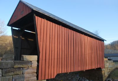
Center Point Covered Bridge is a wooden road bridge in Doddridge County, West Virginia that crosses Pike's Fork, a tributary of McElroy Creek. Built with the Long Truss design, it measures approximately 42 feet (13 meters) long and 12.5 feet (4 meters) wide, featuring a protective wooden roof with shingled covering and a sturdy timber frame.
Built between 1888 and 1890 by local craftsmen including carpenters John Ash and S.H. Smith, the bridge served as a vital crossing for farmers and residents in the rural area. In 1983, it was listed on the National Register of Historic Places, and it underwent major restoration in 2002 to preserve its timber structure.
The bridge is best accessed during daylight hours when you can safely walk across and see the wooden structure clearly from both inside and outside perspectives. Avoid driving large vehicles across, as the bridge is too narrow for most modern cars and serves mainly pedestrian and light vehicle use.
A major restoration project in 2002 spent over 350,000 dollars to preserve the timber structure and keep the bridge safe and stable. This substantial investment underscores how seriously local communities value this link to their past and are committed to keeping it standing for future generations.
The community of curious travelers
AroundUs brings together thousands of curated places, local tips, and hidden gems, enriched daily by 60,000 contributors worldwide.