Enable Location

We need your location to show you interesting places around you

Discover nearby places

Find interesting locations and hidden gems around you

Precise directions

Get accurate directions and distances to places

Your location is never shared with other users. It's only used when you tap the location button.

Chase Woodlands

Log in to your account

Start exploring — it's free

Trusted by 62,569 travelers worldwide

Continue with Google
Continue with Apple
or

We will send you a code to connect

By continuing, you accept our Terms and Conditions and our Privacy Policy

Check your inbox

We've sent a pincode in your inbox. Please enter the code below.

Chase Woodlands

Chase Woodlands, Nature reserve in Dover, Massachusetts.

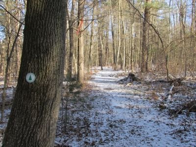
Chase Woodlands is a nature reserve in Dover with forest trails that run through New England landscapes, connecting with Peters Reservation across Farm Street. The property features an interconnected network of paths through different forest types and habitats.

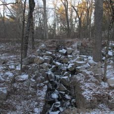
Trustees of Reservations acquired the woodland property in 1993, converting it from agricultural land into a protected natural area. This transformation allowed the forest landscape to be preserved for future generations.

The woodland paths serve as a learning space where local schools conduct environmental studies and nature observation throughout the year. Residents use the trails to connect with the natural life of the region.

Trail maps are available at the entrance and clearly mark the woodland paths, with designated parking near the Farm Street entrance. It helps to wear sturdy shoes and account for forest floor conditions, especially after rain.

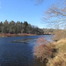
The Charles River Link Trail creates a continuous natural corridor through Chase Woodlands and Peters Reservation, allowing wildlife to move between habitats. This connected corridor matters greatly for the animals living in the region.

The community of curious travelers

AroundUs brings together thousands of curated places, local tips, and hidden gems, enriched daily by 60,000 contributors worldwide.

Start exploring
Location
GPS coordinates
42.23390,-71.32280
Latest update
December 13, 2025 17:06
Around this place
Medfield State Hospital
United States of America

Medfield State Hospital

2.5 km
Museum of World War II
United States of America

Museum of World War II

4.4 km
Hunnewell Estates Historic District
United States of America

Hunnewell Estates Historic District

5.3 km
Elm Bank Horticulture Center
United States of America

Elm Bank Horticulture Center

5 km
Peak House
United States of America

Peak House

5.4 km
Broadmoor Wildlife Sanctuary
United States of America

Broadmoor Wildlife Sanctuary

2.9 km
Fork Factory Brook
United States of America

Fork Factory Brook

4.8 km
Peters Reservation
United States of America

Peters Reservation

540 m
First Parish Unitarian Church
United States of America

First Parish Unitarian Church

5.4 km
Benjamin Caryl House
United States of America

Benjamin Caryl House

4.5 km
Dwight-Derby House
United States of America

Dwight-Derby House

5.3 km
Vine Lake Cemetery
United States of America

Vine Lake Cemetery

5.4 km
The Parsonage
United States of America

The Parsonage

4.2 km
Rev. Stephen Badger House
United States of America

Rev. Stephen Badger House

4 km
John Eliot Historic District
United States of America

John Eliot Historic District

4.3 km
Daniel Morse III House
United States of America

Daniel Morse III House

1.2 km
Charles Holbrook House
United States of America

Charles Holbrook House

3.5 km
Richard Sanger III House
United States of America

Richard Sanger III House

4.7 km
Woodland Farm-Leland House
United States of America

Woodland Farm-Leland House

5 km
Clark-Northrup House
United States of America

Clark-Northrup House

5.3 km
Rev. Edmund Dowse House
United States of America

Rev. Edmund Dowse House

3.5 km
H. G. Vaughn House
United States of America

H. G. Vaughn House

4.9 km
Thomas Fleming House
United States of America

Thomas Fleming House

4.4 km
Asa Sanger House
United States of America

Asa Sanger House

4.8 km
Charles D. Lewis House
United States of America

Charles D. Lewis House

5.3 km
Ware's Tavern
United States of America

Ware's Tavern

3.6 km
Sherborn Center Historic District
United States of America

Sherborn Center Historic District

4.1 km
Morse-Barber House
United States of America

Morse-Barber House

3.1 km
Show the full map
« Chase Woodlands - Nature reserve in Dover, Massachusetts » is provided by Around Us (aroundus.com). Images and texts are derived from Wikimedia project under a Creative Commons license. You are allowed to copy, distribute, and modify copies of this page, under the conditions set by the license, as long as this note is clearly visible.

Discover hidden gems everywhere you go!

From secret cafés to breathtaking viewpoints, skip the crowded tourist spots and find places that match your style. Our app makes it easy with voice search, smart filtering, route optimization, and insider tips from travelers worldwide. Download now for the complete mobile experience.

Around Us App Screenshot

A unique approach to discovering new places

Le Figaro

All the places worth exploring

France Info

A tailor-made excursion in just a few clicks

20 Minutes

Around Us
Travel Guide & Maps
Download

Send to your phone

QR Code
1

Open the camera app on your mobile.

2

Point at the QR code with your camera. A notification will appear.

3

Tap the notification to open the link.