Enable Location

We need your location to show you interesting places around you

Discover nearby places

Find interesting locations and hidden gems around you

Precise directions

Get accurate directions and distances to places

Your location is never shared with other users. It's only used when you tap the location button.

Clarksburg State Park

Log in to your account

Start exploring — it's free

Trusted by 63,125 travelers worldwide

Continue with Google
Continue with Apple
or

We will send you a code to connect

By continuing, you accept our Terms and Conditions and our Privacy Policy

Check your inbox

We've sent a pincode in your inbox. Please enter the code below.

Clarksburg State Park
Discussion Reviews 1 Photos
2.8k Popularity

Clarksburg State Park, State park in Berkshire County, US

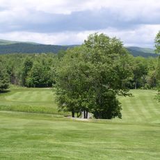
Clarksburg State Park covers 368 acres of northern hardwood forest in Massachusetts, with views toward the Hoosac Range, Mount Greylock, and the Green Mountains beyond. The landscape is defined by thick woods and Mauserts Pond, which sits at the heart of the park.

The park was established by the Massachusetts Department of Conservation and Recreation to protect the natural landscape and provide outdoor recreation for residents. This effort preserved the forest and waters for future generations to enjoy.

Mauserts Pond brings together visitors who come to fish, swim, and paddle non-motorized boats throughout the year. The water draws people seeking outdoor activities and connection with nature.

The park has 46 camping sites available from May through September, with office staff present during weekday hours from 8 AM to 6 PM and weekend hours from 8 AM to midnight. Visitors should plan accordingly, as facilities and services shift with the seasons.

The park has 9.5 miles of trails, including the 3-mile Pond Loop Trail that doubles as a cross-country skiing route when snow covers the ground. Winter brings a completely different character to the same paths.

The community of curious travelers

AroundUs brings together thousands of curated places, local tips, and hidden gems, enriched daily by 60,000 contributors worldwide.

Start exploring
Location
GPS coordinates
42.73470,-73.07640
Latest update
December 12, 2025 14:23
Around this place
Massachusetts Museum of Contemporary Art
United States of America

Massachusetts Museum of Contemporary Art

4.9 km
Natural Bridge State Park
United States of America

Natural Bridge State Park

3.4 km
Western Gateway Heritage State Park
United States of America

Western Gateway Heritage State Park

5.2 km
Wells House
United States of America

Wells House

6.3 km
Hopkins Observatory
United States of America

Hopkins Observatory

10.6 km
Blackinton Historic District
United States of America

Blackinton Historic District

5.3 km
The Boardman
United States of America

The Boardman

5.3 km
Congregation Beth Israel
United States of America

Congregation Beth Israel

8.5 km
Hillside Cemetery
United States of America

Hillside Cemetery

5.5 km
Church Street Historic District
United States of America

Church Street Historic District

4.9 km
North Adams Country Club
United States of America

North Adams Country Club

1.6 km
Beaver Mill
United States of America

Beaver Mill

3.9 km
Hathaway Tenement
United States of America

Hathaway Tenement

5 km
Windsor Print Works
United States of America

Windsor Print Works

4.5 km
Freeman's Grove Historic District
United States of America

Freeman's Grove Historic District

5.3 km
Williamstown Rail Yard and Station Historic District
United States of America

Williamstown Rail Yard and Station Historic District

9.5 km
Charles Browne House
United States of America

Charles Browne House

6.5 km
Tudor House
United States of America

Tudor House

1.9 km
Armstrong House
United States of America

Armstrong House

4.3 km
Crowley House
United States of America

Crowley House

5.7 km
Eber Sherman Farm
United States of America

Eber Sherman Farm

8.5 km
Church Street-Caddy Hill Historic District
United States of America

Church Street-Caddy Hill Historic District

4.9 km
Mill Village Historic District
United States of America

Mill Village Historic District

9.5 km
William B. Sherman Farm
United States of America

William B. Sherman Farm

8.8 km
Sykes House
United States of America

Sykes House

6.1 km
Normal School Historic District
United States of America

Normal School Historic District

5.3 km
Monument Square-Eagle Street Historic District
United States of America

Monument Square-Eagle Street Historic District

5.1 km
Norad Mill
United States of America

Norad Mill

6.5 km
Show the full map
Reviews
Share your experience

No review yet

Discussions
Start a discussion...

No discussion yet

« Clarksburg State Park - State park in Berkshire County, US » is provided by Around Us (aroundus.com). Images and texts are derived from Wikimedia project under a Creative Commons license. You are allowed to copy, distribute, and modify copies of this page, under the conditions set by the license, as long as this note is clearly visible.

Discover hidden gems everywhere you go!

From secret cafés to breathtaking viewpoints, skip the crowded tourist spots and find places that match your style. Our app makes it easy with voice search, smart filtering, route optimization, and insider tips from travelers worldwide. Download now for the complete mobile experience.

Around Us App Screenshot

A unique approach to discovering new places

Le Figaro

All the places worth exploring

France Info

A tailor-made excursion in just a few clicks

20 Minutes

Around Us
Travel Guide & Maps
Download

Send to your phone

QR Code
1

Open the camera app on your mobile.

2

Point at the QR code with your camera. A notification will appear.

3

Tap the notification to open the link.