Enable Location

We need your location to show you interesting places around you

Discover nearby places

Find interesting locations and hidden gems around you

Precise directions

Get accurate directions and distances to places

Your location is never shared with other users. It's only used when you tap the location button.

Coshocton County Courthouse

Log in to your account

Start exploring — it's free

Trusted by 62,595 travelers worldwide

Continue with Google
Continue with Apple
or

We will send you a code to connect

By continuing, you accept our Terms and Conditions and our Privacy Policy

Check your inbox

We've sent a pincode in your inbox. Please enter the code below.

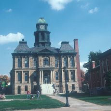
Coshocton County Courthouse, local government building in the United States

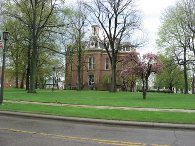
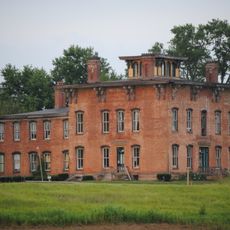
The Coshocton County Courthouse is a brick building in the Second Empire style erected in the 1870s and located on Main Street, featuring red brick walls with stone trim and a distinctive mansard roof. The five-story structure includes dormer windows, a central clock tower with decorative ironwork, arched windows on the upper floors, and wide interior hallways with cast iron staircases.

The courthouse was built between 1873 and 1875 after Coshocton County was established in 1811 and the original courthouse from 1824 became too small for the growing population. The bell originally housed in the earlier building was relocated to the new roof, where it continues to function as a symbol of the town's continuity.

The courthouse is cherished by the community as a symbol of local identity and has hosted significant public gatherings and ceremonies over the years. Its central position makes it a gathering point where residents and visitors appreciate both its architectural details and connection to the town's heritage.

The building is easily accessible as it stands on Main Street in the town center surrounded by public areas where you can walk around freely. Visitors can view the exterior at any time, with daytime visits offering the clearest views of the clock tower and architectural features.

A large mural painted in 1908 inside the courtroom depicts a historic meeting between British Colonel Henry Bouquet and Native Americans near the Walhonding River and served as artist Arthur William Wolfle's first painting. The thirty-foot composition uses vibrant colors to tell a key founding moment of the town and remains one of the building's most noted features.

The community of curious travelers

AroundUs brings together thousands of curated places, local tips, and hidden gems, enriched daily by 60,000 contributors worldwide.

Start exploring
Location
Inception
1873
GPS coordinates
40.27444,-81.86611
Latest update
February 9, 2026 11:07
Around this place
Prospect Place
United States of America

Prospect Place

19.9 km
Age of Steam Roundhouse
United States of America

Age of Steam Roundhouse

28.4 km
Roscoe Village
United States of America

Roscoe Village

922 m
John and Annie Glenn Museum
United States of America

John and Annie Glenn Museum

33.2 km
United States of America

Johnson-Humrickhouse Museum

970 m
Holmes County Courthouse
United States of America

Holmes County Courthouse

31.4 km
William Rainey Harper Log House
United States of America

William Rainey Harper Log House

33.2 km
Helmick Covered Bridge
United States of America

Helmick Covered Bridge

14.7 km
United States of America

Welling Site

18.2 km
Adams-Gray House
United States of America

Adams-Gray House

14.7 km
S Bridge II
United States of America

S Bridge II

32.9 km
Brightman House
United States of America

Brightman House

32 km
Booth Homestead
United States of America

Booth Homestead

25.7 km
Salt Creek Covered Bridge
United States of America

Salt Creek Covered Bridge

30.8 km
Pomerene House
United States of America

Pomerene House

31.7 km
United States of America

G. Adams House

31.5 km
Muskingum River Navigation Historic District
United States of America

Muskingum River Navigation Historic District

1.4 km
Millersburg Christian Church
United States of America

Millersburg Christian Church

31.6 km
United Methodist Church
United States of America

United Methodist Church

31.6 km
Ralph Hardesty Stone House
United States of America

Ralph Hardesty Stone House

32.8 km
Samuel Harper Stone House
United States of America

Samuel Harper Stone House

29.6 km
David Warther Carvings & Gift Shop
United States of America

David Warther Carvings & Gift Shop

31.3 km
Longaberger Homestead
United States of America

Longaberger Homestead

20.9 km
Duncan Theater
United States of America

Duncan Theater

26.7 km
Indian Camp Covered Bridge
United States of America

Indian Camp Covered Bridge

25.8 km
Dresden Suspension Bridge
United States of America

Dresden Suspension Bridge

20.6 km
Stutzman's Crossing
United States of America

Stutzman's Crossing

31.2 km
Jonas Stutzman
United States of America

Jonas Stutzman

31.1 km
Show the full map
« Coshocton County Courthouse - local government building in the United States » is provided by Around Us (aroundus.com). Images and texts are derived from Wikimedia project under a Creative Commons license. You are allowed to copy, distribute, and modify copies of this page, under the conditions set by the license, as long as this note is clearly visible.

Discover hidden gems everywhere you go!

From secret cafés to breathtaking viewpoints, skip the crowded tourist spots and find places that match your style. Our app makes it easy with voice search, smart filtering, route optimization, and insider tips from travelers worldwide. Download now for the complete mobile experience.

Around Us App Screenshot

A unique approach to discovering new places

Le Figaro

All the places worth exploring

France Info

A tailor-made excursion in just a few clicks

20 Minutes

Around Us
Travel Guide & Maps
Download

Send to your phone

QR Code
1

Open the camera app on your mobile.

2

Point at the QR code with your camera. A notification will appear.

3

Tap the notification to open the link.