Enable Location

We need your location to show you interesting places around you

Discover nearby places

Find interesting locations and hidden gems around you

Precise directions

Get accurate directions and distances to places

Your location is never shared with other users. It's only used when you tap the location button.

Dans Mountain

Log in to your account

Start exploring — it's free

Trusted by 62,189 travelers worldwide

Continue with Google
Continue with Apple
or

We will send you a code to connect

By continuing, you accept our Terms and Conditions and our Privacy Policy

Check your inbox

We've sent a pincode in your inbox. Please enter the code below.

Dans Mountain

Dans Mountain, Mountain peak in Allegany County, Maryland, USA

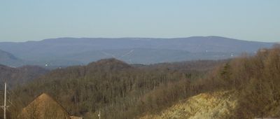
Dans Mountain is a prominent peak in Maryland's Appalachian region featuring a distinctive rocky summit called Dan's Rock. The mountain rises sharply from the surrounding lowlands, with a steep escarpment that dominates the landscape and is visible from many locations in the area.

The peak was named after Daniel Cresap, an early settler in Allegany County who was part of the region's colonial history. The name reflects the early European settlement patterns that shaped this Appalachian area.

The mountain forms part of Dans Mountain State Park, offering 3500 acres of protected land for outdoor recreation and environmental education.

The summit is accessible via a road from Route 36 south of Frostburg, with free parking available at observation areas. Trails in this area are well-established, making the viewpoint on the peak easy to reach for most visitors.

The site features the most substantial rock face among Maryland's mountains, a geological formation that extends across state lines. This dramatic escarpment continues into Pennsylvania and West Virginia, connecting different ridge systems across the region.

The community of curious travelers

AroundUs brings together thousands of curated places, local tips, and hidden gems, enriched daily by 60,000 contributors worldwide.

Start exploring
Location
GPS coordinates
39.58180,-78.89720
Latest update
December 11, 2025 11:04
Around this place
Fort Ashby
United States of America

Fort Ashby

14.1 km
Stone Cottage
United States of America

Stone Cottage

4.4 km
Canal Place
United States of America

Canal Place

13.7 km
Headquarters of George Washington
United States of America

Headquarters of George Washington

13.6 km
B'er Chayim Temple
United States of America

B'er Chayim Temple

14 km
Downtown Cumberland Historic District
United States of America

Downtown Cumberland Historic District

14 km
La Vale Tollgate House
United States of America

La Vale Tollgate House

7.3 km
Klots Throwing Company Mill
United States of America

Klots Throwing Company Mill

13.5 km
Washington Street Historic District
United States of America

Washington Street Historic District

13.3 km
Allegany County Courthouse
United States of America

Allegany County Courthouse

13.6 km
Lonaconing Furnace
United States of America

Lonaconing Furnace

7.1 km
Cumberland YMCA
United States of America

Cumberland YMCA

14.3 km
Public Safety Building
United States of America

Public Safety Building

13.9 km
Bell Tower Building
United States of America

Bell Tower Building

13.9 km
Mount Savage Historic District
United States of America

Mount Savage Historic District

12.8 km
Greene Street Historic District
United States of America

Greene Street Historic District

13.4 km
City Hall
United States of America

City Hall

14 km
First Baptist Church
United States of America

First Baptist Church

14.3 km
Shaw Mansion
United States of America

Shaw Mansion

10.5 km
Francis Haley House
United States of America

Francis Haley House

14.1 km
Rolling Mill Historic District
United States of America

Rolling Mill Historic District

14.1 km
Thomas Koon House
United States of America

Thomas Koon House

14.3 km
Wright Butler House
United States of America

Wright Butler House

14.2 km
Lonaconing Historic District
United States of America

Lonaconing Historic District

7.2 km
Chapel Hill Historic District
United States of America

Chapel Hill Historic District

13.2 km
United States of America

Washington Street Library

13.6 km
Frostburg Cinemas 1-2-3
United States of America

Frostburg Cinemas 1-2-3

7.3 km
Blue Bridge
United States of America

Blue Bridge

13.5 km
Show the full map
« Dans Mountain - Mountain peak in Allegany County, Maryland, USA » is provided by Around Us (aroundus.com). Images and texts are derived from Wikimedia project under a Creative Commons license. You are allowed to copy, distribute, and modify copies of this page, under the conditions set by the license, as long as this note is clearly visible.

Discover hidden gems everywhere you go!

From secret cafés to breathtaking viewpoints, skip the crowded tourist spots and find places that match your style. Our app makes it easy with voice search, smart filtering, route optimization, and insider tips from travelers worldwide. Download now for the complete mobile experience.

Around Us App Screenshot

A unique approach to discovering new places

Le Figaro

All the places worth exploring

France Info

A tailor-made excursion in just a few clicks

20 Minutes

Around Us
Travel Guide & Maps
Download

Send to your phone

QR Code
1

Open the camera app on your mobile.

2

Point at the QR code with your camera. A notification will appear.

3

Tap the notification to open the link.