Enable Location

We need your location to show you interesting places around you

Discover nearby places

Find interesting locations and hidden gems around you

Precise directions

Get accurate directions and distances to places

Your location is never shared with other users. It's only used when you tap the location button.

District 13 Police Station

Log in to your account

Start exploring — it's free

Trusted by 62,575 travelers worldwide

Continue with Google
Continue with Apple
or

We will send you a code to connect

By continuing, you accept our Terms and Conditions and our Privacy Policy

Check your inbox

We've sent a pincode in your inbox. Please enter the code below.

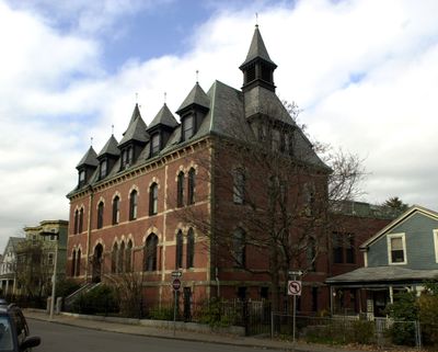
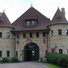
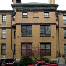
District 13 Police Station, historic police station in Boston, Massachusetts, USA

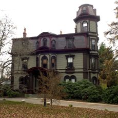
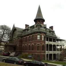
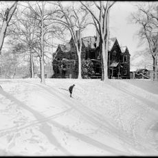
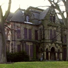
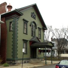
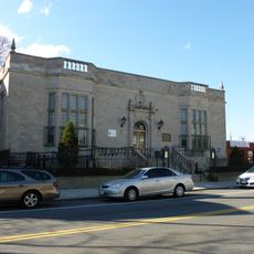
The District 13 Police Station is a High Victorian Gothic-style building in Jamaica Plain, Boston, Massachusetts, distinguished by pointed arch windows and elaborate stonework. The original structure from 1873 was extended in 1892 with an addition that brought further Victorian ornamentation.

The building was constructed in 1873 as the final major public works project of the independent town of West Roxbury before its annexation into Boston in 1874. Architect George Ropes designed the original structure, while Edmund M. Wheelwright added an extension in 1892.

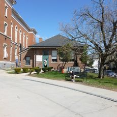
The building carries the name District 13 Police Station and stands in Jamaica Plain, a neighborhood with diverse history and community. The Victorian details and Gothic architecture shape the streetscape today and connect residents to the city's past.

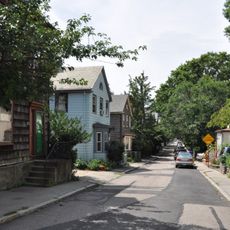
The building sits in a quiet, tree-lined residential neighborhood and can be easily viewed from the sidewalk. Its proximity to local shops and homes makes it a pleasant destination for walks through the area.

The building is the only municipal structure in Jamaica Plain built in High Victorian Gothic style, making it stand out among the simpler designs in the neighborhood. This rare architectural choice shows how local authorities wanted to express the authority and importance of the police station through its form.

The community of curious travelers

AroundUs brings together thousands of curated places, local tips, and hidden gems, enriched daily by 60,000 contributors worldwide.

Start exploring
Location
Architects
Edmund M. Wheelwright
GPS coordinates
42.31206,-71.11233
Latest update
February 9, 2026 08:19
Around this place
Emerald Necklace
United States of America

Emerald Necklace

1.6 km
Arnold Arboretum
United States of America

Arnold Arboretum

1.8 km
Franklin Park
United States of America

Franklin Park

1.9 km
Larz Anderson Park
United States of America

Larz Anderson Park

2 km
Larz Anderson Auto Museum
United States of America

Larz Anderson Auto Museum

1.9 km
Southwest Corridor Park
United States of America

Southwest Corridor Park

1.9 km
Ellen Swallow Richards House
United States of America

Ellen Swallow Richards House

438 m
Lucy Parsons Center
United States of America

Lucy Parsons Center

1.2 km
Death and the Sculptor
United States of America

Death and the Sculptor

1.6 km
Adams-Nervine Asylum
United States of America

Adams-Nervine Asylum

1.4 km
Dimock Community Health Center Complex
United States of America

Dimock Community Health Center Complex

1.5 km
Pinebank Mansion
United States of America

Pinebank Mansion

1 km
Abbotsford
United States of America

Abbotsford

1.7 km
Loring-Greenough House
United States of America

Loring-Greenough House

351 m
Putterham School
United States of America

Putterham School

1.8 km
Pill Hill Historic District
United States of America

Pill Hill Historic District

1.9 km
Home for Aged Couples
United States of America

Home for Aged Couples

1.4 km
Bowditch School
United States of America

Bowditch School

236 m
Eliot Hall
United States of America

Eliot Hall

360 m
Sumner Hill Historic District
United States of America

Sumner Hill Historic District

262 m
Monument Square Historic District
United States of America

Monument Square Historic District

408 m
White Place Historic District
United States of America

White Place Historic District

1.3 km
Doris Bunte Apartments
United States of America

Doris Bunte Apartments

1.3 km
Blessed Sacrament Church
United States of America

Blessed Sacrament Church

1.3 km
House at 17 Cranston Street
United States of America

House at 17 Cranston Street

1 km
Connolly Branch Library
United States of America

Connolly Branch Library

959 m
Jamaica Plain Branch Library
United States of America

Jamaica Plain Branch Library

451 m
Egleston Square Branch Library
United States of America

Egleston Square Branch Library

1.4 km
Show the full map
« District 13 Police Station - historic police station in Boston, Massachusetts, USA » is provided by Around Us (aroundus.com). Images and texts are derived from Wikimedia project under a Creative Commons license. You are allowed to copy, distribute, and modify copies of this page, under the conditions set by the license, as long as this note is clearly visible.

Discover hidden gems everywhere you go!

From secret cafés to breathtaking viewpoints, skip the crowded tourist spots and find places that match your style. Our app makes it easy with voice search, smart filtering, route optimization, and insider tips from travelers worldwide. Download now for the complete mobile experience.

Around Us App Screenshot

A unique approach to discovering new places

Le Figaro

All the places worth exploring

France Info

A tailor-made excursion in just a few clicks

20 Minutes

Around Us
Travel Guide & Maps
Download

Send to your phone

QR Code
1

Open the camera app on your mobile.

2

Point at the QR code with your camera. A notification will appear.

3

Tap the notification to open the link.