Southwest Corridor Park

Log in to your account

AroundUs is a community-driven map of interesting places, built by curious explorers like you. It grows with every review, story, and photo you share.
Connect to save your favorite spots, contribute locations, and create personalized routes.
By continuing, you accept our Terms and Conditions and our Privacy Policy
Add to collection
Map
Suggest a change
Share

Southwest Corridor Park, Linear state park in Suffolk County, United States
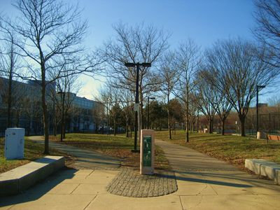
Southwest Corridor Park extends 4.1 miles from Back Bay to Forest Hills, featuring pathways alongside the Orange Line transit system and railway tracks.

The land was initially designated for Interstate 95 construction in the 1960s until community protests led to the cancellation of the highway project in 1969.

The park connects diverse Boston neighborhoods including South End, Back Bay, Roxbury, and Jamaica Plain through a network of green spaces and recreational facilities.

Visitors can access eleven playgrounds, seven basketball courts, five tennis courts, two hockey rinks, and six miles of trails from dawn until dusk.

The park transformation from a planned interstate highway to an urban green corridor demonstrates successful community activism in Boston during the twentieth century.

Location: Massachusetts

Inception: 1987

Website: https://mass.gov/locations/southwest-corridor-park

GPS coordinates: 42.32640,-71.09890

Latest update: May 23, 2025 19:14

Around this place
Show the full map
Isabella Stewart Gardner Museum
United States of America

Isabella Stewart Gardner Museum

1.3 km
Emerald Necklace
United States of America

Emerald Necklace

1.3 km
Warren Anatomical Museum
United States of America

Warren Anatomical Museum

1.1 km
Roxbury Highlands Historic District
United States of America

Roxbury Highlands Historic District

693 m
1767 Milestones
United States of America

1767 Milestones

737 m
Malcolm X—Ella Little-Collins House
United States of America

Malcolm X—Ella Little-Collins House

1.2 km
Roxbury Heritage State Park
United States of America

Roxbury Heritage State Park

809 m
Roxbury High Fort
United States of America

Roxbury High Fort

387 m
Dimock Community Health Center Complex
United States of America

Dimock Community Health Center Complex

804 m
Boston Medical Library
United States of America

Boston Medical Library

1.1 km
St. Joseph Catholic Church
United States of America

St. Joseph Catholic Church

957 m
Abbotsford
United States of America

Abbotsford

1.2 km
William Lloyd Garrison House
United States of America

William Lloyd Garrison House

414 m
Timothy Hoxie House
United States of America

Timothy Hoxie House

742 m
Edward Everett Hale House
United States of America

Edward Everett Hale House

595 m
Alvah Kittredge House
United States of America

Alvah Kittredge House

554 m
John Eliot Square District
United States of America

John Eliot Square District

760 m
Dudley Station Historic District
United States of America

Dudley Station Historic District

1.3 km
Dillaway School
United States of America

Dillaway School

992 m
Harriswood Crescent
United States of America

Harriswood Crescent

1.2 km
Francis Street-Fenwood Road Historic District
United States of America

Francis Street-Fenwood Road Historic District

1.1 km
Edward H. Haskell Home for Nurses
United States of America

Edward H. Haskell Home for Nurses

1 km
Doris Bunte Apartments
United States of America

Doris Bunte Apartments

1.2 km
Blessed Sacrament Church
United States of America

Blessed Sacrament Church

798 m
MassArt Art Museum
United States of America

MassArt Art Museum

1.1 km
House at 17 Cranston Street
United States of America

House at 17 Cranston Street

1.1 km
Roxbury Parting Stone
United States of America

Roxbury Parting Stone

721 m
Connolly Branch Library
United States of America

Connolly Branch Library

1.2 km
Show the full map

Reviews

Visited this place? Tap the stars to rate it and share your experience / photos with the community! Try now! You can cancel it anytime.

« Southwest Corridor Park: Linear state park in Suffolk County, United States » is provided by Around Us (aroundus.com). Images and texts are derived from Wikimedia project under a Creative Commons license. You are allowed to copy, distribute, and modify copies of this page, under the conditions set by the license, as long as this note is clearly visible.

Discover hidden gems everywhere you go!

From secret cafés to breathtaking viewpoints, skip the crowded tourist spots and find places that match your style. Our app makes it easy with voice search, smart filtering, route optimization, and insider tips from travelers worldwide. Download now for the complete mobile experience.

Around Us App Screenshot

A unique approach to discovering new places

Le Figaro

All the places worth exploring

France Info

A tailor-made excursion in just a few clicks

20 Minutes