Enable Location

We need your location to show you interesting places around you

Discover nearby places

Find interesting locations and hidden gems around you

Precise directions

Get accurate directions and distances to places

Your location is never shared with other users. It's only used when you tap the location button.

Dexter–Huron Metropark

Log in to your account

Start exploring — it's free

Trusted by 62,443 travelers worldwide

Continue with Google
Continue with Apple
or

We will send you a code to connect

By continuing, you accept our Terms and Conditions and our Privacy Policy

Check your inbox

We've sent a pincode in your inbox. Please enter the code below.

Dexter–Huron Metropark

Dexter–Huron Metropark, park in Michigan, United States of America

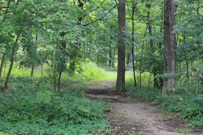
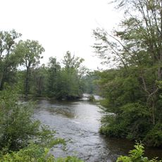
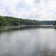
Dexter-Huron Metropark is a park along the Huron River in Washtenaw County with trees, open green spaces, and paved pathways that connect to the larger Border-to-Border trail system. The grounds feature bridges crossing small streams, picnic shelters with tables and grills, a softball field, and direct access to the river for fishing and paddling.

The area has drawn people to relax, picnic, and enjoy nature for many years as a natural gathering place. It was developed as a metropark to preserve this tradition and connect the land to larger trail networks across Michigan.

The stone labyrinth built by a local Girl Scout troop in 2008 invites visitors to walk its winding paths for quiet contemplation. This feature connects community effort with the natural landscape and offers a moment of personal reflection during your visit.

The park opens early morning through evening and offers paved, flat pathways suitable for all ages, with bike rentals available near the main facility. Accessible trails and picnic shelters make it welcoming for visitors with mobility needs.

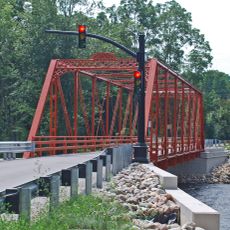
Trains occasionally run nearby and can be heard along the river, reminding visitors of the area's transportation history. This unexpected connection surprises visitors and adds a layer of industrial heritage to the natural setting.

The community of curious travelers

AroundUs brings together thousands of curated places, local tips, and hidden gems, enriched daily by 60,000 contributors worldwide.

Start exploring
Location
GPS coordinates
42.32980,-83.85990
Latest update
February 9, 2026 07:42
Around this place
Blind Pig Cafe
United States of America

Blind Pig Cafe

10.5 km
Ann Arbor Hands-On Museum
United States of America

Ann Arbor Hands-On Museum

10.8 km
Delhi Bridge
United States of America

Delhi Bridge

4.2 km
Hudson Mills Metropark
United States of America

Hudson Mills Metropark

7.5 km
The Ark
United States of America

The Ark

10.7 km
Ann Arbor Hands-On Museum and Leslie Science & Nature Center
United States of America

Ann Arbor Hands-On Museum and Leslie Science & Nature Center

10.7 km
Peach Mountain Observatory
United States of America

Peach Mountain Observatory

9.9 km
Argus Museum
United States of America

Argus Museum

10.4 km
St. Patrick's Parish Complex
United States of America

St. Patrick's Parish Complex

9.6 km
Delhi Metropark
United States of America

Delhi Metropark

4.3 km
St. Thomas the Apostle Catholic Church
United States of America

St. Thomas the Apostle Catholic Church

11 km
Michigan Cooperative House
United States of America

Michigan Cooperative House

11 km
Bell Road Bridge
United States of America

Bell Road Bridge

8.9 km
Stefan T. Vail Cooperative House
United States of America

Stefan T. Vail Cooperative House

11 km
Judge Robert S. Wilson House
United States of America

Judge Robert S. Wilson House

11 km
Washtenaw County Administration Building
United States of America

Washtenaw County Administration Building

10.6 km
James Litchfield House
United States of America

James Litchfield House

2.1 km
Jacob Hoffstetter House
United States of America

Jacob Hoffstetter House

11 km
Methodist Episcopal Church Parsonage
United States of America

Methodist Episcopal Church Parsonage

11 km
Kellogg-Warden House
United States of America

Kellogg-Warden House

10.5 km
Thomas Earl House
United States of America

Thomas Earl House

10.5 km
Blue Heron Bay Splash Park
United States of America

Blue Heron Bay Splash Park

10 km
Barton Pond
United States of America

Barton Pond

7.2 km
Michigan Central Railroad Depot Historical Marker
United States of America

Michigan Central Railroad Depot Historical Marker

10.8 km
Saint Thomas the Apostle Church Historical Marker
United States of America

Saint Thomas the Apostle Church Historical Marker

11 km
Saint Patrick's Church Historical Marker
United States of America

Saint Patrick's Church Historical Marker

9.5 km
Michigan Becomes a State Historical Marker
United States of America

Michigan Becomes a State Historical Marker

10.7 km
Bethlehem United Church of Christ Historical Marker
United States of America

Bethlehem United Church of Christ Historical Marker

11 km
Show the full map
« Dexter–Huron Metropark - park in Michigan, United States of America » is provided by Around Us (aroundus.com). Images and texts are derived from Wikimedia project under a Creative Commons license. You are allowed to copy, distribute, and modify copies of this page, under the conditions set by the license, as long as this note is clearly visible.

Discover hidden gems everywhere you go!

From secret cafés to breathtaking viewpoints, skip the crowded tourist spots and find places that match your style. Our app makes it easy with voice search, smart filtering, route optimization, and insider tips from travelers worldwide. Download now for the complete mobile experience.

Around Us App Screenshot

A unique approach to discovering new places

Le Figaro

All the places worth exploring

France Info

A tailor-made excursion in just a few clicks

20 Minutes

Around Us
Travel Guide & Maps
Download

Send to your phone

QR Code
1

Open the camera app on your mobile.

2

Point at the QR code with your camera. A notification will appear.

3

Tap the notification to open the link.