Enable Location

We need your location to show you interesting places around you

Discover nearby places

Find interesting locations and hidden gems around you

Precise directions

Get accurate directions and distances to places

Your location is never shared with other users. It's only used when you tap the location button.

Dillingham House

Log in to your account

Start exploring — it's free

Trusted by 62,572 travelers worldwide

Continue with Google
Continue with Apple
or

We will send you a code to connect

By continuing, you accept our Terms and Conditions and our Privacy Policy

Check your inbox

We've sent a pincode in your inbox. Please enter the code below.

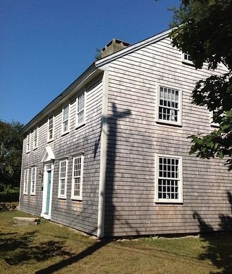
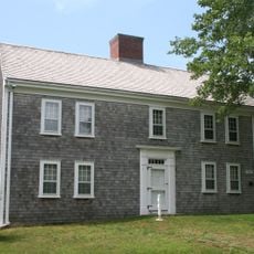
Dillingham House, First period house in Brewster, Massachusetts.

The Dillingham House is a first period residence in Brewster with a traditional saltbox design and timber-frame construction. The building features small multi-paned windows and other characteristic elements typical of New England architecture.

The house was built before 1660 by John Dillingham and ranks among the oldest residences in Massachusetts. Between 1915 and 1918 it underwent major renovations, including the addition of a shed dormer and extra rooms.

The interior shows timber beams from the 17th century alongside wooden paneling from the 18th century, revealing how residents adapted and expanded their spaces over time. These visible layers tell the story of changing tastes and needs across colonial generations.

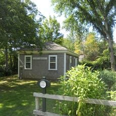
The house is located in a quiet area of Brewster and is easy to reach. Visitors should check ahead to understand what viewing options are available, as access can vary.

The house's complete saltbox form has remained largely unchanged since colonial times, making it a rare example of how these early structures were originally built. This continuity offers a direct look at residential life from the 1600s.

The community of curious travelers

AroundUs brings together thousands of curated places, local tips, and hidden gems, enriched daily by 60,000 contributors worldwide.

Start exploring
Location
GPS coordinates
41.74917,-70.12528
Latest update
December 14, 2025 18:42
Around this place
Cape Cod Rail Trail
United States of America

Cape Cod Rail Trail

4.5 km
Nickerson State Park
United States of America

Nickerson State Park

7.8 km
Cape Cod Coliseum
United States of America

Cape Cod Coliseum

8.8 km
Cape Cod Regional Technical High School
United States of America

Cape Cod Regional Technical High School

6.1 km
Scargo Tower
United States of America

Scargo Tower

4.7 km
Nickerson Mansion
United States of America

Nickerson Mansion

6.6 km
Mayflower Beach
United States of America

Mayflower Beach

7.4 km
Cape Cod Museum of Art
United States of America

Cape Cod Museum of Art

5.5 km
Josiah Dennis House
United States of America

Josiah Dennis House

6.2 km
United States of America

Old Higgins Farm Windmill

485 m
West Schoolhouse
United States of America

West Schoolhouse

6.3 km
Corporation Beach
United States of America

Corporation Beach

5.1 km
Brewster Old King's Highway Historic District
United States of America

Brewster Old King's Highway Historic District

3.4 km
Harwich Historic District
United States of America

Harwich Historic District

8.4 km
Jacob Sears Memorial Library
United States of America

Jacob Sears Memorial Library

1.7 km
Stony Brook-Factory Village Historic District
United States of America

Stony Brook-Factory Village Historic District

3.4 km
Cape Playhouse
United States of America

Cape Playhouse

5.6 km
Crosby Landing Beach
United States of America

Crosby Landing Beach

8.8 km
Taylor-Bray Farm
United States of America

Taylor-Bray Farm

7.3 km
Crowe's Pasture
United States of America

Crowe's Pasture

1.4 km
Linnell Landing Beach
United States of America

Linnell Landing Beach

8.1 km
Ellis Landing Beach
United States of America

Ellis Landing Beach

6.5 km
Paine's Creek Beach
United States of America

Paine's Creek Beach

1.7 km
Sesuit Beach
United States of America

Sesuit Beach

2.4 km
Robbins Hill Beach
United States of America

Robbins Hill Beach

2 km
Point of Rocks Landing Beach
United States of America

Point of Rocks Landing Beach

5.2 km
Saints Landing Beach
United States of America

Saints Landing Beach

2.4 km
Bayview Beach
United States of America

Bayview Beach

7.6 km
Show the full map
« Dillingham House - First period house in Brewster, Massachusetts » is provided by Around Us (aroundus.com). Images and texts are derived from Wikimedia project under a Creative Commons license. You are allowed to copy, distribute, and modify copies of this page, under the conditions set by the license, as long as this note is clearly visible.

Discover hidden gems everywhere you go!

From secret cafés to breathtaking viewpoints, skip the crowded tourist spots and find places that match your style. Our app makes it easy with voice search, smart filtering, route optimization, and insider tips from travelers worldwide. Download now for the complete mobile experience.

Around Us App Screenshot

A unique approach to discovering new places

Le Figaro

All the places worth exploring

France Info

A tailor-made excursion in just a few clicks

20 Minutes

Around Us
Travel Guide & Maps
Download

Send to your phone

QR Code
1

Open the camera app on your mobile.

2

Point at the QR code with your camera. A notification will appear.

3

Tap the notification to open the link.