Enable Location

We need your location to show you interesting places around you

Discover nearby places

Find interesting locations and hidden gems around you

Precise directions

Get accurate directions and distances to places

Your location is never shared with other users. It's only used when you tap the location button.

Elliott Knob

Log in to your account

Start exploring — it's free

Trusted by 61,987 travelers worldwide

Continue with Google
Continue with Apple
or

We will send you a code to connect

By continuing, you accept our Terms and Conditions and our Privacy Policy

Check your inbox

We've sent a pincode in your inbox. Please enter the code below.

Elliott Knob

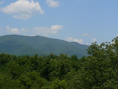
Elliott Knob, Mountain summit in Augusta County, Virginia.

Elliott Knob is a mountain summit in Augusta County reaching 4,463 feet (1,361 m) in elevation. The slopes are covered with oak, hickory, yellow birch, and sugar maple trees.

The mountain was shaped by geological processes that formed the southern Appalachian region. A surveying marker from the National Geodetic Survey near the base helped establish its precise geographical position.

Boy Scouts from Camp Shenandoah regularly undertake a 14-mile hiking journey to reach the mountain summit as part of their outdoor activities.

Two main trails reach the summit: North Mountain Trail at 4.6 miles and Mount Crawford Trail at 2.6 miles, both marked with yellow blazes. Both routes offer a natural ascent with clear markings to guide hikers along the way.

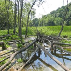
The summit is home to a natural stand of red spruce trees, which typically grow in northern regions far from this location. A year-round spring and small artificial pond provide water and support the forest ecosystem.

The community of curious travelers

AroundUs brings together thousands of curated places, local tips, and hidden gems, enriched daily by 60,000 contributors worldwide.

Start exploring
Location
Part of
Ridge-and-Valley Appalachians
GPS coordinates
38.16658,-79.31414
Latest update
December 11, 2025 18:07
Around this place
United States of America

Polyface Farm

9.3 km
Ramsey's Draft Wilderness
United States of America

Ramsey's Draft Wilderness

18.8 km
Folly Mills Creek Fen Natural Area Preserve
United States of America

Folly Mills Creek Fen Natural Area Preserve

17.5 km
Trinity Episcopal Church
United States of America

Trinity Episcopal Church

21 km
Breezy Hill
United States of America

Breezy Hill

21.2 km
Fort Edward Johnson
United States of America

Fort Edward Johnson

17.7 km
Stuart House
United States of America

Stuart House

21 km
Bethel Green
United States of America

Bethel Green

18.4 km
Beverley Historic District
United States of America

Beverley Historic District

21.2 km
C. W. Miller House
United States of America

C. W. Miller House

21.2 km
Deerfield School
United States of America

Deerfield School

8.6 km
National Valley Bank
United States of America

National Valley Bank

21.2 km
Steephill
United States of America

Steephill

19.9 km
Intervale
United States of America

Intervale

11.5 km
Clover Mount
United States of America

Clover Mount

20.9 km
Lewis Shuey House
United States of America

Lewis Shuey House

9.3 km
Middlebrook Historic District
United States of America

Middlebrook Historic District

15.5 km
Newtown Historic District (Staunton, Virginia)
United States of America

Newtown Historic District (Staunton, Virginia)

20.6 km
Glebe Schoolhouse
United States of America

Glebe Schoolhouse

10.3 km
Hanger Mill
United States of America

Hanger Mill

16.7 km
Wharf Area Historic District
United States of America

Wharf Area Historic District

21.2 km
Augusta County Training School
United States of America

Augusta County Training School

16.1 km
Henry Mish Barn
United States of America

Henry Mish Barn

13.8 km
Maple Front Farm
United States of America

Maple Front Farm

13.6 km
The Wilderness
United States of America

The Wilderness

15.6 km
A. J. Miller House
United States of America

A. J. Miller House

17.5 km
Craigsville School
United States of America

Craigsville School

11.3 km
Moffett's Creek Schoolhouse
United States of America

Moffett's Creek Schoolhouse

18.3 km
Show the full map
« Elliott Knob - Mountain summit in Augusta County, Virginia » is provided by Around Us (aroundus.com). Images and texts are derived from Wikimedia project under a Creative Commons license. You are allowed to copy, distribute, and modify copies of this page, under the conditions set by the license, as long as this note is clearly visible.

Discover hidden gems everywhere you go!

From secret cafés to breathtaking viewpoints, skip the crowded tourist spots and find places that match your style. Our app makes it easy with voice search, smart filtering, route optimization, and insider tips from travelers worldwide. Download now for the complete mobile experience.

Around Us App Screenshot

A unique approach to discovering new places

Le Figaro

All the places worth exploring

France Info

A tailor-made excursion in just a few clicks

20 Minutes

Around Us
Travel Guide & Maps
Download

Send to your phone

QR Code
1

Open the camera app on your mobile.

2

Point at the QR code with your camera. A notification will appear.

3

Tap the notification to open the link.