Enable Location

We need your location to show you interesting places around you

Discover nearby places

Find interesting locations and hidden gems around you

Precise directions

Get accurate directions and distances to places

Your location is never shared with other users. It's only used when you tap the location button.

Elliott Laurel

Log in to your account

Start exploring — it's free

Trusted by 62,475 travelers worldwide

Continue with Google
Continue with Apple
or

We will send you a code to connect

By continuing, you accept our Terms and Conditions and our Privacy Policy

Check your inbox

We've sent a pincode in your inbox. Please enter the code below.

Elliott Laurel

Elliott Laurel, Natural preserve in Phillipston, Massachusetts, United States.

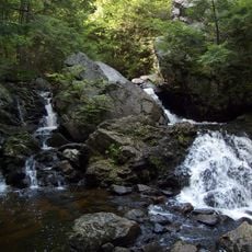
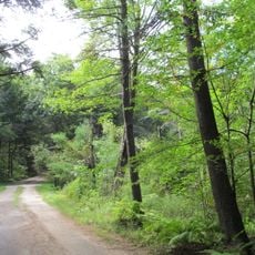
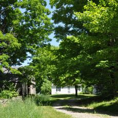
Elliott Laurel is a protected woodland in Phillipston that spans multiple dozen acres with mountain laurel shrubs, rocky outcrops, and developed trail networks. The terrain includes varied forest sections ranging from dense thickets to more open areas beneath tall pines.

Frederick W. Elliott donated the land to The Trustees of Reservations in 1941, beginning this protected area's history. Additional land purchases during the 1970s expanded the preserve to its current size.

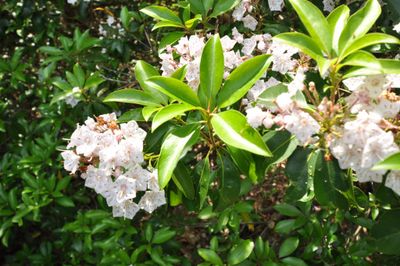
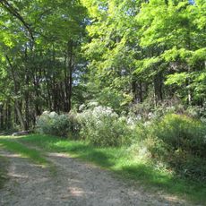
The preserve protects native mountain laurel populations that grow naturally throughout this woodland area. Visitors walking the trails encounter these flowering plants as part of the local ecosystem they help maintain.

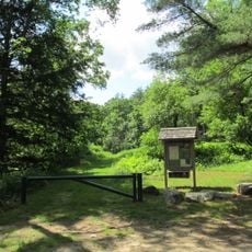
The one-mile trail can be walked year-round or used for cross-country skiing in winter, with parking available off Queen Lake Road. Access is straightforward and the paths work for different skill levels.

The southern section features an elevated vantage point beneath tall pines surrounded by mountain laurel thickets that turn white when blooming in June. This spot offers a quieter retreat away from main trails.

The community of curious travelers

AroundUs brings together thousands of curated places, local tips, and hidden gems, enriched daily by 60,000 contributors worldwide.

Start exploring
Location
GPS coordinates
42.49440,-72.17530
Latest update
December 14, 2025 09:43
Around this place
Harvard Forest
United States of America

Harvard Forest

4.3 km
Bear's Den
United States of America

Bear's Den

13.5 km
Templeton Developmental Center
United States of America

Templeton Developmental Center

12.6 km
Swift River Reservation
United States of America

Swift River Reservation

5.3 km
Federated Women's Club State Forest
United States of America

Federated Women's Club State Forest

6.5 km
Brooks Woodland Preserve
United States of America

Brooks Woodland Preserve

0 m
North Common Meadow
United States of America

North Common Meadow

0 m
Ware River Diversion
United States of America

Ware River Diversion

14.9 km
Whitaker-Clary House
United States of America

Whitaker-Clary House

12.6 km
Gay Farm
United States of America

Gay Farm

3.5 km
Petersham Common Historic District
United States of America

Petersham Common Historic District

959 m
Orange Center Historic District
United States of America

Orange Center Historic District

15.4 km
Hubbardston Public Library
United States of America

Hubbardston Public Library

13.9 km
Mount Grace Land Conservation Trust
United States of America

Mount Grace Land Conservation Trust

14.8 km
Old Town Hall
United States of America

Old Town Hall

11.4 km
Hubbardston Town Common Historic District
United States of America

Hubbardston Town Common Historic District

14.1 km
Baldwinville Village Historic District
United States of America

Baldwinville Village Historic District

14.7 km
District No. 5 School
United States of America

District No. 5 School

3.6 km
Kensington Park Historic District
United States of America

Kensington Park Historic District

14.5 km
New Salem Common Historic District
United States of America

New Salem Common Historic District

12.8 km
Barre Common District
United States of America

Barre Common District

9.9 km
Prescott Town House
United States of America

Prescott Town House

846 m
Phillipston Center Historic District
United States of America

Phillipston Center Historic District

7 km
Templeton Common Historic District
United States of America

Templeton Common Historic District

11.1 km
No. 4 Schoolhouse
United States of America

No. 4 Schoolhouse

9.2 km
Rev. Samuel Gay House
United States of America

Rev. Samuel Gay House

13.2 km
District No. 4 School
United States of America

District No. 4 School

2 km
Holland-Towne House
United States of America

Holland-Towne House

1 km
Show the full map
« Elliott Laurel - Natural preserve in Phillipston, Massachusetts, United States » is provided by Around Us (aroundus.com). Images and texts are derived from Wikimedia project under a Creative Commons license. You are allowed to copy, distribute, and modify copies of this page, under the conditions set by the license, as long as this note is clearly visible.

Discover hidden gems everywhere you go!

From secret cafés to breathtaking viewpoints, skip the crowded tourist spots and find places that match your style. Our app makes it easy with voice search, smart filtering, route optimization, and insider tips from travelers worldwide. Download now for the complete mobile experience.

Around Us App Screenshot

A unique approach to discovering new places

Le Figaro

All the places worth exploring

France Info

A tailor-made excursion in just a few clicks

20 Minutes

Around Us
Travel Guide & Maps
Download

Send to your phone

QR Code
1

Open the camera app on your mobile.

2

Point at the QR code with your camera. A notification will appear.

3

Tap the notification to open the link.