Enable Location

We need your location to show you interesting places around you

Discover nearby places

Find interesting locations and hidden gems around you

Precise directions

Get accurate directions and distances to places

Your location is never shared with other users. It's only used when you tap the location button.

Log in to your account

Start exploring — it's free

Trusted by 63,592 travelers worldwide

Continue with Google
Continue with Apple
or

We will send you a code to connect

By continuing, you accept our Terms and Conditions and our Privacy Policy

Check your inbox

We've sent a pincode in your inbox. Please enter the code below.

Discussion Reviews Photo
22.2k Popularity

Kanchanpur District, Administrative district in Sudurpashchim Province, Nepal.

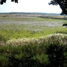
This administrative district spans an area between the Siwalik hills and the Terai plains, with varied terrain ranging from low elevations to forested uplands. The landscape transitions from flat agricultural areas to rolling hills as you move north.

The area came under Nepali control in 1860 following a treaty arrangement that reshaped territorial boundaries in the region. This shift ended a period of British influence and established new political borders.

Chhetri, Tharu, and Hill Brahmin communities shape daily life and local practices throughout the region. You hear Doteli, Tharu, and Nepali spoken in markets and along the streets.

Bhimdatta serves as the administrative center where you can access local government services and information. The district is organized into several municipalities and rural areas, each with their own services and local offices.

The Mahakali River forms the border with India and holds a notable suspension bridge that connects both countries. This structure serves as a key crossing point and an engineering feature that locals and travelers frequently mention.

The community of curious travelers

AroundUs brings together thousands of curated places, local tips, and hidden gems, enriched daily by 60,000 contributors worldwide.

Start exploring
Location
Capital city
Bhimdatta
GPS coordinates
28.83333,80.33333
Latest update
December 22, 2025 09:50
Reviews
Share your experience

No review yet

Discussions
Start a discussion...

No discussion yet

« Kanchanpur District - Administrative district in Sudurpashchim Province, Nepal » is provided by Around Us (aroundus.com). Images and texts are derived from Wikimedia project under a Creative Commons license. You are allowed to copy, distribute, and modify copies of this page, under the conditions set by the license, as long as this note is clearly visible.

Discover hidden gems everywhere you go!

From secret cafés to breathtaking viewpoints, skip the crowded tourist spots and find places that match your style. Our app makes it easy with voice search, smart filtering, route optimization, and insider tips from travelers worldwide. Download now for the complete mobile experience.

Around Us App Screenshot

A unique approach to discovering new places

Le Figaro

All the places worth exploring

France Info

A tailor-made excursion in just a few clicks

20 Minutes

Around Us
Travel Guide & Maps
Download

Send to your phone

QR Code
1

Open the camera app on your mobile.

2

Point at the QR code with your camera. A notification will appear.

3

Tap the notification to open the link.