Baião, Municipality in Porto District, Portugal
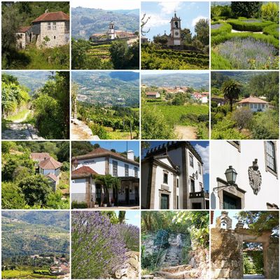
Baião is a municipality in northern Portugal that covers roughly 175 square kilometers, bordered by Amarante to the north and Marco de Canaveses to the west. The territory is divided into 14 civil parishes and features a varied landscape with historical sites and ancient structures.
King Manuel I granted Baião official municipality status through a charter dated September 1, 1513, marking its formal administrative recognition as a separate territory. This royal decree was a turning point in the region's administrative development.
Santo André de Ancede Convent, standing since 1113, reflects the religious heritage of the region and draws visitors interested in medieval architecture. The megalithic remains at Aboboreira Mountain reveal that this area has been inhabited since prehistoric times.
Visitors can access local government services and information about the 14 civil parishes through the official website cm-baiao.pt. This is a useful starting point for understanding the local administrative structure and available services.
The Gestaçô area produces traditional walking sticks through specialized craftsmanship techniques passed down across generations. This distinctive local craft remains visible to visitors exploring the region today.
Location: Porto
Location: Tâmega e Sousa subregion
Elevation above the sea: 576 m
Shares border with: Amarante, Mesão Frio, Peso da Régua, Resende, Cinfães, Marco de Canaveses, Santa Marta de Penaguião
Website: https://cm-baiao.pt
GPS coordinates: 41.16667,-8.03333
Latest update: December 7, 2025 10:08
Serra do Marão
15.3 km
Anta da Aboboreira
4.6 km
Mosteirô Bridge
9.1 km
Solar da Rede
12.2 km
Igreja de São Martinho de Mouros
13.4 km
Igreja e Mosteiro de Santo André de Ancede, Capela do Bom Despacho e terreiro fronteiro
7.5 km
Megalithic site of Meninas do Crasto
4 km
Ponte do Arco
7.7 km
Megalithic site of Outeiro de Gregos
2.4 km
Iglesia Parroquial de São Bartolomeu
584 m
Igreja Matriz de Barrô
13.3 km
Megalithic site of Outeiro de Ante
2.7 km
Igreja de São Tiago, paroquial de Valadares
4.9 km
Igreja de Ermelo
7.4 km
Igreja matriz de Soalhães
5.4 km
Igreja de Jazente
8.9 km
Pelourinho de Mesão Frio
12.2 km
Pillory of Rua
9.6 km
Igreja Paroquial de Teixeira
9.6 km
Pelourinho de São Martinho de Mouros
13.5 km
Torre de Novões, ou Nevões, incluindo o edifício anexo
7 km
Câmara Municipal de Mesão Frio
11.9 km
Câmara Municipal de Resende
8.9 km
Capela de São Silvestre (Mesão Frio)
11.2 km
Hospital da Misericórdia de Mesão Frio
11.8 km
Casa de Tormes
5.3 km
Casa do Vale do Couto
12.2 km
Capela de Nossa Senhora dos Remédios
9.7 kmVisited this place? Tap the stars to rate it and share your experience / photos with the community! Try now! You can cancel it anytime.
Discover hidden gems everywhere you go!
From secret cafés to breathtaking viewpoints, skip the crowded tourist spots and find places that match your style. Our app makes it easy with voice search, smart filtering, route optimization, and insider tips from travelers worldwide. Download now for the complete mobile experience.
A unique approach to discovering new places❞
— Le Figaro
All the places worth exploring❞
— France Info
A tailor-made excursion in just a few clicks❞
— 20 Minutes