Saint Petersburg Dam, Flood control dam in Saint Petersburg, Russia.
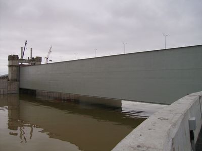
The Saint Petersburg Dam is a flood control structure spanning across the Gulf of Finland and connecting multiple pieces of land. The construction includes navigation channels for ships, multi-lane roadways, and was designed as an integrated system to meet both protection and transportation needs.
Construction of this flood control system began in the late 1970s as a response to storm surge threats that regularly endangered the city. The project went through different construction phases over decades before reaching completion in the early 2000s.
The structure is viewed by residents as a symbol of Russian engineering prowess and has become part of the city's daily landscape. Many people use the road built on top for commuting across the Gulf, making it a practical connection woven into everyday life.
The dam can be reached from several access points, and the road built on top offers wide views across the Gulf and the city. Visitors should remember that weather on the water can change quickly, so dressing appropriately is advisable.
The structure has special navigation openings that allow ships to pass through while maintaining the protective effect. This technical detail makes the construction more than a simple barrier, as it accounts for both ships and the city's needs.
Location: Saint Petersburg
GPS coordinates: 60.00639,29.74833
Latest update: December 6, 2025 21:22
Category:Monument to City of Military Glory (Kronstadt)
824 m
Kronverksky Canal
940 m
1-я северная оборонительная казарма с сухопутным манежем (Кронштадт)
1.1 km
Эскарповая стена (Кронштадт)
1.1 km
Bellingshausen Cenotaph in Kronstadt
467 m
Posadskaya Street, 5
1.1 km
Кенотаф адмирала А.И. Круза (1727-1799) (Кронштадт)
465 m
Главный земляной вал (Кронштадт)
1.1 km
Дом именитого гражданина Пароского (Кронштадт)
1.2 km
Жилой дом купца Мурашова (Кронштадт)
1.2 km
Казарма (Кронштадт)
1.1 km
Северное батардо с капониром (Кронштадт)
899 m
Здание штаба Кронштадтской крепости (Кронштадт)
982 m
Barracks of Kronstadt Fortress Miners
1.1 km
Здание пассажирской станции «Город» (Кронштадт)
1.2 km
Офицерское собрание и канцелярия (Кронштадт)
1 km
2-я западная оборонительная казарма (Кронштадтская) с полубашней (Кронштадт)
997 m
Парк (Кронштадт)
1 km
Ледник (Кронштадт)
1 km
Казарма для офицеров (Кронштадт)
1.2 km
Казарма (Кронштадт)
1.1 km
Кенотаф адмирала Р.Н. Вирена (1857-1917) (Кронштадт)
474 m
Братская могила мирных жителей г. Кронштадта, погибших в Великую Отечественную войну (Кронштадт)
439 m
Hospital No36, Kronstadt
1.1 km
Казарма (Кронштадт)
911 m
Казарма (Кронштадт)
870 m
Posadskaya Street, 8
1.2 km
Казарма (Кронштадт)
1.2 kmVisited this place? Tap the stars to rate it and share your experience / photos with the community! Try now! You can cancel it anytime.
Discover hidden gems everywhere you go!
From secret cafés to breathtaking viewpoints, skip the crowded tourist spots and find places that match your style. Our app makes it easy with voice search, smart filtering, route optimization, and insider tips from travelers worldwide. Download now for the complete mobile experience.
A unique approach to discovering new places❞
— Le Figaro
All the places worth exploring❞
— France Info
A tailor-made excursion in just a few clicks❞
— 20 Minutes