Calhoun County

Log in to your account

AroundUs is a community-driven map of interesting places, built by curious explorers like you. It grows with every review, story, and photo you share.
Connect to save your favorite spots, contribute locations, and create personalized routes.
By continuing, you accept our Terms and Conditions and our Privacy Policy
Add to collection
Map
Suggest a change
Share

Calhoun County, Administrative county in central Iowa, United States

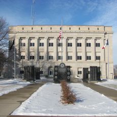
Calhoun County is an agricultural county in central Iowa covering roughly 572 square miles of farmland and small towns. Rockwell City serves as the county seat and the largest community in the area.

The county was established in 1851 under the name Fox County and renamed in 1853 to honor John C. Calhoun, the seventh vice president of the United States. This change was part of broader administrative reorganization efforts in Iowa.

The communities here are deeply rooted in farming, and you can see this in how people organize their daily lives. The landscape and local activities reflect generations of agricultural work.

The county is connected by U.S. Highway 20 and several state highways that link all the towns and villages together. A car is necessary for getting around since public transportation options are limited.

A powerful tornado struck the town of Pomeroy on July 6, 1893, destroying much of the community and leaving a lasting mark on local memory. This remains one of Iowa's most severe weather events from that era.

Location: Iowa

Inception: January 15, 1851

Capital city: Rockwell City

Shares border with: Pocahontas County, Carroll County, Sac County, Webster County, Greene County, Buena Vista County

Website: http://calhouncountyiowa.com

GPS coordinates: 42.38611,-94.64722

Latest update: December 10, 2025 15:59

Photos
Around this place
Black Hawk State Park
United States of America

Black Hawk State Park

32.6 km
George H. Gallup House
United States of America

George H. Gallup House

39.1 km
Marsh Rainbow Arch Bridge
United States of America

Marsh Rainbow Arch Bridge

19.5 km
St. Patrick's Catholic Church, Cedar
United States of America

St. Patrick's Catholic Church, Cedar

26.4 km
Saints Peter and Paul Catholic Church
United States of America

Saints Peter and Paul Catholic Church

38.9 km
Sac County Courthouse
United States of America

Sac County Courthouse

28.6 km
Calhoun County Courthouse
United States of America

Calhoun County Courthouse

1.4 km
Jesse J. and Mary F. Allee House
United States of America

Jesse J. and Mary F. Allee House

37.4 km
Chief Black Hawk Statue
United States of America

Chief Black Hawk Statue

33.7 km
Pocahontas County Courthouse
United States of America

Pocahontas County Courthouse

39.1 km
Lakeside Park Historic District
United States of America

Lakeside Park Historic District

34 km
Sac City Monument Square Historic District
United States of America

Sac City Monument Square Historic District

28.3 km
Seven Oaks
United States of America

Seven Oaks

28.6 km
Peter and Mary Smith House
United States of America

Peter and Mary Smith House

15.1 km
Sac City Chicago and North Western Depot
United States of America

Sac City Chicago and North Western Depot

29.3 km
Lake City Community Memorial Building
United States of America

Lake City Community Memorial Building

14.9 km
Smith Farmhouse
United States of America

Smith Farmhouse

15.7 km
Lorenzo S. Coffin Burial Plot
United States of America

Lorenzo S. Coffin Burial Plot

36.9 km
Lake City Public Library
United States of America

Lake City Public Library

14.9 km
Lake City Water Standpipe
United States of America

Lake City Water Standpipe

14.9 km
George and Lola Perkins House
United States of America

George and Lola Perkins House

28.7 km
Central School
United States of America

Central School

15.2 km
Gen. Cass and Belle Smith House
United States of America

Gen. Cass and Belle Smith House

15.2 km
Park Hotel
United States of America

Park Hotel

28.4 km
Perry C. and Mattie Forrest Holdoegel House
United States of America

Perry C. and Mattie Forrest Holdoegel House

1.1 km
Blackhawk State Park, Denison Beach Area
United States of America

Blackhawk State Park, Denison Beach Area

33.3 km
Blackhawk State Park, Wildlife Preserve Area (Area A)
United States of America

Blackhawk State Park, Wildlife Preserve Area (Area A)

34.4 km
Blackhawk State Park, Black Hawk Preserve (Area B)
United States of America

Blackhawk State Park, Black Hawk Preserve (Area B)

33.9 km
Show the full map
Reviews

Visited this place? Tap the stars to rate it and share your experience / photos with the community! Try now! You can cancel it anytime.

« Calhoun County - Administrative county in central Iowa, United States » is provided by Around Us (aroundus.com). Images and texts are derived from Wikimedia project under a Creative Commons license. You are allowed to copy, distribute, and modify copies of this page, under the conditions set by the license, as long as this note is clearly visible.

Discover hidden gems everywhere you go!

From secret cafés to breathtaking viewpoints, skip the crowded tourist spots and find places that match your style. Our app makes it easy with voice search, smart filtering, route optimization, and insider tips from travelers worldwide. Download now for the complete mobile experience.

Around Us App Screenshot

A unique approach to discovering new places

Le Figaro

All the places worth exploring

France Info

A tailor-made excursion in just a few clicks

20 Minutes