Interstate 57

Log in to your account

AroundUs is a community-driven map of interesting places, built by curious explorers like you. It grows with every review, story, and photo you share.
Connect to save your favorite spots, contribute locations, and create personalized routes.
By continuing, you accept our Terms and Conditions and our Privacy Policy
Add to collection
Map
Suggest a change
Share

Interstate 57, Interstate highway in Illinois, United States

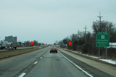
Interstate 57 is a federal highway extending 364 miles (586 km) through Illinois and Missouri, connecting Chicago with southern regions and passing through central Illinois communities. The road serves as a major north-south corridor linking the northern and southern United States.

The highway was constructed in several stages throughout the 1960s as part of the national Interstate Highway System expansion. Its development reflected the mid-century focus on connecting major metropolitan areas and regional centers through modern divided highways.

This highway serves as one of few Chicago freeways known by its numerical designation rather than a commemorative name, reflecting regional transportation traditions.

The highway provides regular access to rest areas, gas stations, and dining options along its length. Traffic can be heavy near major urban areas, particularly during peak travel hours and holiday seasons.

Interstate 57 runs parallel to the former Illinois Central Railroad tracks, creating a transportation corridor that shaped the development of multiple Illinois communities.

Location: Illinois

Location: Missouri

Inception: 1956

GPS coordinates: 39.37428,-88.41286

Latest update: December 14, 2025 19:10

Photos
Around this place
Lincoln Log Cabin State Historic Site
United States of America

Lincoln Log Cabin State Historic Site

18.1 km
Pemberton Hall
United States of America

Pemberton Hall

23.7 km
Old Main
United States of America

Old Main

23.8 km
Cumberland County Courthouse
United States of America

Cumberland County Courthouse

18.5 km
Health Education Building
United States of America

Health Education Building

23.6 km
Coles County Courthouse
United States of America

Coles County Courthouse

24.5 km
Moultrie County Courthouse
United States of America

Moultrie County Courthouse

30.1 km
Alexander Briggs House
United States of America

Alexander Briggs House

24.1 km
Clarksburg Schoolhouse
United States of America

Clarksburg Schoolhouse

29.4 km
Unity Church
United States of America

Unity Church

12.4 km
Harrison Street Bridge
United States of America

Harrison Street Bridge

28.8 km
United States Post Office (Mattoon, Illinois)
United States of America

United States Post Office (Mattoon, Illinois)

12.3 km
Thornton Ward Estate
United States of America

Thornton Ward Estate

23.6 km
Will Rogers Theatre
United States of America

Will Rogers Theatre

24.5 km
McFarland House
United States of America

McFarland House

24.3 km
Greenup Commercial Historic District
United States of America

Greenup Commercial Historic District

25.8 km
Burgess-Osborne Memorial Auditorium
United States of America

Burgess-Osborne Memorial Auditorium

12.3 km
Blakeman Bridge
United States of America

Blakeman Bridge

24.7 km
Richard Roytek House
United States of America

Richard Roytek House

12.4 km
Sixth, Seventh, and Tenth Street Stone Arch Bridges
United States of America

Sixth, Seventh, and Tenth Street Stone Arch Bridges

24.4 km
Lumpkin Heights and Elm Ridge Subdivision Historic District
United States of America

Lumpkin Heights and Elm Ridge Subdivision Historic District

12.8 km
Two-Story Outhouse
United States of America

Two-Story Outhouse

11.8 km
Trinity Lutheran Church
United States of America

Trinity Lutheran Church

29.6 km
Heart Theater
United States of America

Heart Theater

30.3 km
St Francis Catholic Church
United States of America

St Francis Catholic Church

27.4 km
Gays Water Tower
United States of America

Gays Water Tower

11.8 km
Civilian Conservation Corps Camp Shiloh Encampment Site
United States of America

Civilian Conservation Corps Camp Shiloh Encampment Site

17.5 km
Lake Shelbyville
United States of America

Lake Shelbyville

28.1 km
Show the full map
Reviews

Visited this place? Tap the stars to rate it and share your experience / photos with the community! Try now! You can cancel it anytime.

« Interstate 57 - Interstate highway in Illinois, United States » is provided by Around Us (aroundus.com). Images and texts are derived from Wikimedia project under a Creative Commons license. You are allowed to copy, distribute, and modify copies of this page, under the conditions set by the license, as long as this note is clearly visible.

Discover hidden gems everywhere you go!

From secret cafés to breathtaking viewpoints, skip the crowded tourist spots and find places that match your style. Our app makes it easy with voice search, smart filtering, route optimization, and insider tips from travelers worldwide. Download now for the complete mobile experience.

Around Us App Screenshot

A unique approach to discovering new places

Le Figaro

All the places worth exploring

France Info

A tailor-made excursion in just a few clicks

20 Minutes