Enable Location

We need your location to show you interesting places around you

Discover nearby places

Find interesting locations and hidden gems around you

Precise directions

Get accurate directions and distances to places

Your location is never shared with other users. It's only used when you tap the location button.

Health Education Building

Log in to your account

Start exploring — it's free

Trusted by 62,173 travelers worldwide

Continue with Google
Continue with Apple
or

We will send you a code to connect

By continuing, you accept our Terms and Conditions and our Privacy Policy

Check your inbox

We've sent a pincode in your inbox. Please enter the code below.

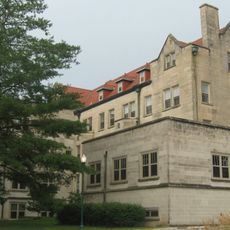
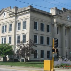
Health Education Building, School building in Illinois, United States.

The Health Education Building is a school structure in Illinois designed with traditional educational architecture in mind. Its exterior displays symmetrical window patterns and balanced proportions characteristic of institutional buildings from its construction period.

The structure was designed by the architectural firm Hewitt and Emerson and subsequently earned recognition on the National Register of Historic Places. This designation reflects its importance as an educational facility within Illinois.

The building represents the American commitment to health education infrastructure during the period of institutional expansion in Illinois.

Historical records and photographs are available through the National Park Service database for those interested in learning more about the building. Online access makes it easy to review documentation about its architectural features and historical context.

The building maintains its educational function while simultaneously serving as a documented example of architectural preservation in the Midwest.

The community of curious travelers

AroundUs brings together thousands of curated places, local tips, and hidden gems, enriched daily by 60,000 contributors worldwide.

Start exploring
Location
Architects
Hewitt & Emerson
GPS coordinates
39.48167,-88.17639
Latest update
December 14, 2025 18:16
Around this place
Ashmore Estates
United States of America

Ashmore Estates

12.1 km
Lincoln Log Cabin State Historic Site
United States of America

Lincoln Log Cabin State Historic Site

11.5 km
Airtight Bridge
United States of America

Airtight Bridge

11.1 km
Pemberton Hall
United States of America

Pemberton Hall

216 m
Old Main
United States of America

Old Main

297 m
Cumberland County Courthouse
United States of America

Cumberland County Courthouse

24 km
Stone Quarry Bridge
United States of America

Stone Quarry Bridge

7.2 km
Coles County Courthouse
United States of America

Coles County Courthouse

1.5 km
Alexander Briggs House
United States of America

Alexander Briggs House

1.4 km
Arcola Carnegie Public Library
United States of America

Arcola Carnegie Public Library

25.2 km
Dr. Hiram Rutherford House and Office
United States of America

Dr. Hiram Rutherford House and Office

23.1 km
Unity Church
United States of America

Unity Church

17.7 km
Harrison Street Bridge
United States of America

Harrison Street Bridge

5.5 km
United States Post Office (Mattoon, Illinois)
United States of America

United States Post Office (Mattoon, Illinois)

17.1 km
Richland County Courthouse
United States of America

Richland County Courthouse

28.8 km
Thornton Ward Estate
United States of America

Thornton Ward Estate

28.4 km
Will Rogers Theatre
United States of America

Will Rogers Theatre

1.5 km
McFarland House
United States of America

McFarland House

990 m
Greenup Commercial Historic District
United States of America

Greenup Commercial Historic District

26.1 km
Burgess-Osborne Memorial Auditorium
United States of America

Burgess-Osborne Memorial Auditorium

17.1 km
Blakeman Bridge
United States of America

Blakeman Bridge

3.7 km
Richard Roytek House
United States of America

Richard Roytek House

19.2 km
Sixth, Seventh, and Tenth Street Stone Arch Bridges
United States of America

Sixth, Seventh, and Tenth Street Stone Arch Bridges

1.2 km
Lumpkin Heights and Elm Ridge Subdivision Historic District
United States of America

Lumpkin Heights and Elm Ridge Subdivision Historic District

15.4 km
World's Largest Pitchfork
United States of America

World's Largest Pitchfork

25.1 km
Two-Story Outhouse
United States of America

Two-Story Outhouse

27.5 km
Gays Water Tower
United States of America

Gays Water Tower

27.6 km
Civilian Conservation Corps Camp Shiloh Encampment Site
United States of America

Civilian Conservation Corps Camp Shiloh Encampment Site

11.5 km
Show the full map
« Health Education Building - School building in Illinois, United States » is provided by Around Us (aroundus.com). Images and texts are derived from Wikimedia project under a Creative Commons license. You are allowed to copy, distribute, and modify copies of this page, under the conditions set by the license, as long as this note is clearly visible.

Discover hidden gems everywhere you go!

From secret cafés to breathtaking viewpoints, skip the crowded tourist spots and find places that match your style. Our app makes it easy with voice search, smart filtering, route optimization, and insider tips from travelers worldwide. Download now for the complete mobile experience.

Around Us App Screenshot

A unique approach to discovering new places

Le Figaro

All the places worth exploring

France Info

A tailor-made excursion in just a few clicks

20 Minutes

Around Us
Travel Guide & Maps
Download

Send to your phone

QR Code
1

Open the camera app on your mobile.

2

Point at the QR code with your camera. A notification will appear.

3

Tap the notification to open the link.