Taylor County

Log in to your account

AroundUs is a community-driven map of interesting places, built by curious explorers like you. It grows with every review, story, and photo you share.
Connect to save your favorite spots, contribute locations, and create personalized routes.
By continuing, you accept our Terms and Conditions and our Privacy Policy
Add to collection
Map
Suggest a change
Share

Taylor County, Administrative division in Kentucky, United States

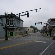
Taylor County is an administrative division in central Kentucky with Campbellsville as its county seat, covering about 277 square miles. The county provides local services including an animal shelter, emergency management, and fire protection to serve its residents.

The county was established on January 13, 1848, as Kentucky's 100th county and was named after United States Army General Zachary Taylor. This naming honored a prominent military leader from the nation's early history.

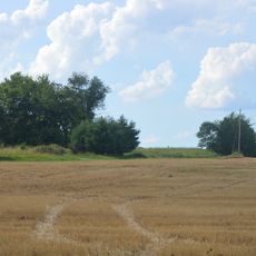
Residents here carry forward traditions brought by early settlers from eastern states like Virginia and Pennsylvania, which continue to shape local customs and community life. These deep roots from the founding families influence how people connect with their land and neighbors today.

The county is centrally located in Kentucky and can be accessed by local roads, with Campbellsville serving as the hub for most services. Visitors should note that government services operate during standard business hours, so planning ahead is wise if you need specific assistance.

The county boundaries form the shape of a heart, giving the region an unexpected geometric quality. Additionally, a historic magnetic survey marker from 1916 identifies the geographical center of this heart-shaped territory.

Location: Kentucky

Inception: January 13, 1848

Capital city: Campbellsville

Shares border with: Marion County, Casey County, Adair County, Green County, LaRue County

Website: http://taylorcounty.us

GPS coordinates: 37.37000,-85.33000

Latest update: December 10, 2025 15:52

Photos
Around this place
Bernheim Forest and  Arboretum
United States of America

Bernheim Forest and Arboretum

21.3 km
Green River Lake State Park
United States of America

Green River Lake State Park

10.5 km
Downtown Greensburg Historic District (Greensburg, Kentucky)
United States of America

Downtown Greensburg Historic District (Greensburg, Kentucky)

19.4 km
Battle of Tebb's Bend Monument
United States of America

Battle of Tebb's Bend Monument

15.6 km
Lebanon National Cemetery
United States of America

Lebanon National Cemetery

21.1 km
Captain Andrew Offutt Monument
United States of America

Captain Andrew Offutt Monument

24 km
Federal House
United States of America

Federal House

19.6 km
Sulphur Well Historic District
United States of America

Sulphur Well Historic District

40.3 km
Mt. Gilead Baptist Church
United States of America

Mt. Gilead Baptist Church

22.7 km
Campbellsville Historic Commercial District
United States of America

Campbellsville Historic Commercial District

3.4 km
Casey County Courthouse
United States of America

Casey County Courthouse

35 km
Adair County Courthouse
United States of America

Adair County Courthouse

29.8 km
Dr. Nathan Gaither House
United States of America

Dr. Nathan Gaither House

29.7 km
Greensburg Cumberland Presbyterian Church
United States of America

Greensburg Cumberland Presbyterian Church

19.4 km
Liberty Downtown Historic District
United States of America

Liberty Downtown Historic District

35 km
Daniel Trabue House
United States of America

Daniel Trabue House

30.1 km
Washington County Courthouse
United States of America

Washington County Courthouse

36.4 km
Lebanon Historic Commercial District
United States of America

Lebanon Historic Commercial District

23.2 km
Anderson House
United States of America

Anderson House

20.2 km
Columbia Commercial Historic District
United States of America

Columbia Commercial Historic District

29.8 km
Green County Court Clerk's Office
United States of America

Green County Court Clerk's Office

19.5 km
John Field House
United States of America

John Field House

30 km
Zion Meetinghouse and School
United States of America

Zion Meetinghouse and School

36.1 km
William Blackwell House
United States of America

William Blackwell House

36 km
James Caldwell House
United States of America

James Caldwell House

12.1 km
Keltner House
United States of America

Keltner House

20.1 km
Star Theater
United States of America

Star Theater

40.9 km
Goose Creek Foot Bridge
United States of America

Goose Creek Foot Bridge

19.4 km
Show the full map
Reviews

Visited this place? Tap the stars to rate it and share your experience / photos with the community! Try now! You can cancel it anytime.

« Taylor County - Administrative division in Kentucky, United States » is provided by Around Us (aroundus.com). Images and texts are derived from Wikimedia project under a Creative Commons license. You are allowed to copy, distribute, and modify copies of this page, under the conditions set by the license, as long as this note is clearly visible.

Discover hidden gems everywhere you go!

From secret cafés to breathtaking viewpoints, skip the crowded tourist spots and find places that match your style. Our app makes it easy with voice search, smart filtering, route optimization, and insider tips from travelers worldwide. Download now for the complete mobile experience.

Around Us App Screenshot

A unique approach to discovering new places

Le Figaro

All the places worth exploring

France Info

A tailor-made excursion in just a few clicks

20 Minutes