Chest opened
+${chestReward.xp} XP
Explorer
NOUVEAU ×${chestReward.collectible.quantity}
tapez pour fermer
Chest locked

Open chests in the app

Around Us is built for your phone — chests unlock when you walk, explore and capture nearby places.

Enable Location

We need your location to show you interesting places around you

Discover nearby places

Find interesting locations and hidden gems around you

Precise directions

Get accurate directions and distances to places

Your location is never shared with other users. It's only used when you tap the location button.

Gnadenhutten

Log in to your account

Start exploring — it's free

Trusted by 72,888 travelers worldwide

Continue with Google
Continue with Apple
or

We will send you a code to connect

By continuing, you accept our Terms and Conditions and our Privacy Policy

Check your inbox

We've sent a pincode in your inbox. Please enter the code below.

Discussion Reviews 1 Photos
15.2k Popularity

Gnadenhutten, Administrative village in Tuscarawas County, Ohio, United States.

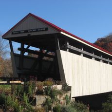
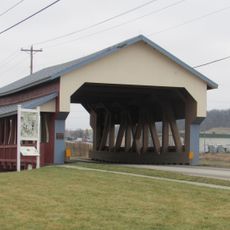
Gnadenhutten is a small village in Tuscarawas County, Ohio, situated along a river and home to around 1,200 people. The town consists of residential neighborhoods with local schools and basic services that meet everyday community needs.

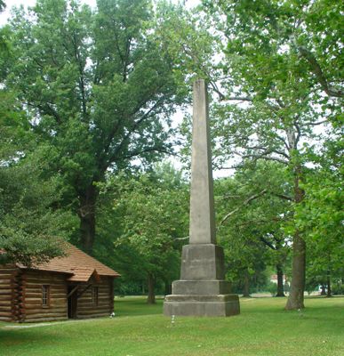
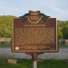
The settlement was founded in 1772 by Moravian Christians and Native Americans working together to build a shared community. A tragic event in 1782 resulted in the death of many Lenape people and left a lasting mark on the area's story.

The village carries forward the legacy of its German-American founders, evident in how residents honor their heritage through community events and local traditions. Walking through town, you notice how this cultural identity shapes the character of everyday life here.

The village has a local school system serving students from elementary through high school ages. Visitors should expect a small rural community with more limited services and infrastructure compared to larger towns.

The name comes from German words meaning 'Huts of Grace,' reflecting the spiritual mission of its founders. The settlement ranks among Ohio's oldest continuously inhabited places and carries important regional significance for this reason.

The community of curious travelers

AroundUs brings together thousands of curated places, local tips, and hidden gems, enriched daily by 60,000 contributors worldwide.

Start exploring
GPS coordinates
40.35840,-81.43428
Latest update
December 7, 2025 19:31
Around this place
Salt Fork State Park
United States of America

Salt Fork State Park

29 km
Atwood Lake
United States of America

Atwood Lake

22.6 km
Age of Steam Roundhouse
United States of America

Age of Steam Roundhouse

23.8 km
Fort Laurens
United States of America

Fort Laurens

31.3 km
Leesville Lake
United States of America

Leesville Lake

23.7 km
Kennedy Stone House
United States of America

Kennedy Stone House

26.2 km
Conotton Creek Trail
United States of America

Conotton Creek Trail

31.7 km
Tuscarawas County Courthouse
United States of America

Tuscarawas County Courthouse

14.7 km
Jeremiah Reeves House and Carriage House
United States of America

Jeremiah Reeves House and Carriage House

17.7 km
Booth Homestead
United States of America

Booth Homestead

20.8 km
Uhrichsville Water Park
United States of America

Uhrichsville Water Park

9 km
Dennison High School
United States of America

Dennison High School

9.4 km
Ourant's School
United States of America

Ourant's School

27.3 km
Henry Law Farm Historic District
United States of America

Henry Law Farm Historic District

16.5 km
Deersville Historic District
United States of America

Deersville Historic District

21.5 km
Fort Laurens Museum
United States of America

Fort Laurens Museum

31.4 km
David Warther Carvings & Gift Shop
United States of America

David Warther Carvings & Gift Shop

28 km
Camp Muskigum Beach
United States of America

Camp Muskigum Beach

27.2 km
Historic Zoar Village
United States of America

Historic Zoar Village

28.3 km
Ernest Warther Museum and Gardens
United States of America

Ernest Warther Museum and Gardens

19.2 km
Piedmont Lake
United States of America

Piedmont Lake

32.3 km
John Reaves House
United States of America

John Reaves House

21.8 km
Camp NEOSA Beach
United States of America

Camp NEOSA Beach

27.4 km
Skull Fork Covered Bridge
United States of America

Skull Fork Covered Bridge

24.2 km
Atwood Lake Beach
United States of America

Atwood Lake Beach

24.6 km
Camp Aldersgate Beach
United States of America

Camp Aldersgate Beach

26.6 km
Gnadenhutten
United States of America

Gnadenhutten

510 m
Stutzman's Crossing
United States of America

Stutzman's Crossing

30.8 km
Show the full map
Reviews
Share your experience

No review yet

Discussions
Start a discussion...

No discussion yet

« Gnadenhutten - Administrative village in Tuscarawas County, Ohio, United States » is provided by Around Us (aroundus.com). Images and texts are derived from Wikimedia project under a Creative Commons license. You are allowed to copy, distribute, and modify copies of this page, under the conditions set by the license, as long as this note is clearly visible.

Discover hidden gems everywhere you go!

From secret cafés to breathtaking viewpoints, skip the crowded tourist spots and find places that match your style. Our app makes it easy with voice search, smart filtering, route optimization, and insider tips from travelers worldwide. Download now for the complete mobile experience.

Around Us App Screenshot

A unique approach to discovering new places

Le Figaro

All the places worth exploring

France Info

A tailor-made excursion in just a few clicks

20 Minutes

Around Us
Travel Guide & Maps
Download

Send to your phone

QR Code
1

Open the camera app on your mobile.

2

Point at the QR code with your camera. A notification will appear.

3

Tap the notification to open the link.