Enable Location

We need your location to show you interesting places around you

Discover nearby places

Find interesting locations and hidden gems around you

Precise directions

Get accurate directions and distances to places

Your location is never shared with other users. It's only used when you tap the location button.

Salt Fork State Park

Log in to your account

Start exploring — it's free

Trusted by 62,534 travelers worldwide

Continue with Google
Continue with Apple
or

We will send you a code to connect

By continuing, you accept our Terms and Conditions and our Privacy Policy

Check your inbox

We've sent a pincode in your inbox. Please enter the code below.

Salt Fork State Park

Salt Fork State Park, State park in Lore City, United States.

Salt Fork State Park is a large recreation area in Ohio with a reservoir and extensive outdoor facilities spread across the land and water. Two marinas serve boaters, seven launch ramps provide access to the water, and an 18-hole golf course sits alongside a sandy swimming beach.

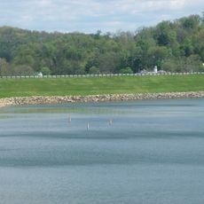
An earthen dam built in 1967 created the lake and transformed the landscape into a recreation area. Salt Fork Lodge opened its doors in 1972 to serve visitors exploring this newly developed space.

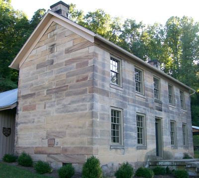
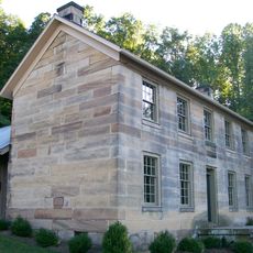
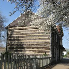
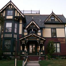
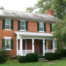
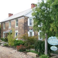
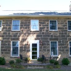
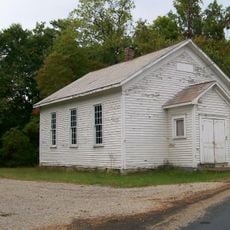
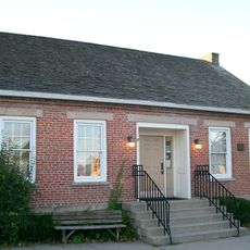
The Kennedy Stone House on the grounds reflects how people once lived in this region through its preserved architecture. Walking past it gives you a sense of the local building traditions from earlier times.

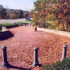
The park has several entrances and well-marked trails making it easy to navigate different areas depending on what you want to do. Bring comfortable walking shoes and check weather conditions before visiting, as some paths can get muddy during heavy rain.

Anglers can catch largemouth bass, crappie, bluegill, walleye, and muskellunge in the water year-round, with different seasons bringing better odds for different species. This mix of fish makes it appealing to both casual fishers and serious enthusiasts.

The community of curious travelers

AroundUs brings together thousands of curated places, local tips, and hidden gems, enriched daily by 60,000 contributors worldwide.

Start exploring
Location
Inception
1960
GPS coordinates
40.10220,-81.49800
Latest update
December 8, 2025 13:41
Around this place
John and Annie Glenn Museum
United States of America

John and Annie Glenn Museum

23.7 km
Barnesville Petroglyph
United States of America

Barnesville Petroglyph

26.5 km
Kennedy Stone House
United States of America

Kennedy Stone House

2.9 km
S Bridge, National Road
United States of America

S Bridge, National Road

12.3 km
William Rainey Harper Log House
United States of America

William Rainey Harper Log House

23.5 km
Guernsey County Courthouse
United States of America

Guernsey County Courthouse

14.6 km
Belmont County Victorian Mansion Museum
United States of America

Belmont County Victorian Mansion Museum

30.3 km
Barnesville Historic District
United States of America

Barnesville Historic District

29.9 km
Colonel Joseph Taylor House
United States of America

Colonel Joseph Taylor House

11.1 km
S Bridge II
United States of America

S Bridge II

24.4 km
Bethel Methodist Episcopal Church
United States of America

Bethel Methodist Episcopal Church

23.5 km
Booth Homestead
United States of America

Booth Homestead

13.4 km
Samuel Danford Farm
United States of America

Samuel Danford Farm

30 km
Broom-Braden Stone House
United States of America

Broom-Braden Stone House

6.3 km
Salt Creek Covered Bridge
United States of America

Salt Creek Covered Bridge

31.3 km
McCracken-McFarland House
United States of America

McCracken-McFarland House

11.5 km
Broom Building
United States of America

Broom Building

11.7 km
Ralph Hardesty Stone House
United States of America

Ralph Hardesty Stone House

28.1 km
Samuel Harper Stone House
United States of America

Samuel Harper Stone House

20.4 km
Abner Williams Log House
United States of America

Abner Williams Log House

21 km
West Union School
United States of America

West Union School

30.9 km
Barnett-Criss House
United States of America

Barnett-Criss House

20.1 km
National Road & Zane Grey Museum
United States of America

National Road & Zane Grey Museum

31.1 km
Piedmont Lake
United States of America

Piedmont Lake

26.8 km
John Reaves House
United States of America

John Reaves House

23 km
Guernsey County District Public Library
United States of America

Guernsey County District Public Library

11.6 km
Indian Camp Covered Bridge
United States of America

Indian Camp Covered Bridge

12.9 km
Skull Fork Covered Bridge
United States of America

Skull Fork Covered Bridge

21.5 km
Show the full map
« Salt Fork State Park - State park in Lore City, United States » is provided by Around Us (aroundus.com). Images and texts are derived from Wikimedia project under a Creative Commons license. You are allowed to copy, distribute, and modify copies of this page, under the conditions set by the license, as long as this note is clearly visible.

Discover hidden gems everywhere you go!

From secret cafés to breathtaking viewpoints, skip the crowded tourist spots and find places that match your style. Our app makes it easy with voice search, smart filtering, route optimization, and insider tips from travelers worldwide. Download now for the complete mobile experience.

Around Us App Screenshot

A unique approach to discovering new places

Le Figaro

All the places worth exploring

France Info

A tailor-made excursion in just a few clicks

20 Minutes

Around Us
Travel Guide & Maps
Download

Send to your phone

QR Code
1

Open the camera app on your mobile.

2

Point at the QR code with your camera. A notification will appear.

3

Tap the notification to open the link.