S Bridge, National Road

Log in to your account

AroundUs is a community-driven map of interesting places, built by curious explorers like you. It grows with every review, story, and photo you share.
Connect to save your favorite spots, contribute locations, and create personalized routes.
Continue with Google
Continue with Apple
Continue with X
Continue with Facebook
Continue with email
By continuing, you accept our Terms and Conditions and our Privacy Policy
Create an account
Add to collection
Map
Suggest a change
Share

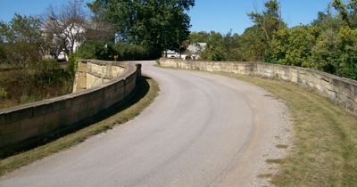
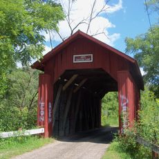
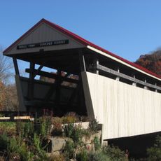
S Bridge, National Road, Historic stone arch bridge in Old Washington, United States

The S Bridge is a stone arch bridge crossing Salt Fork near Old Washington, characterized by its distinctive S-shaped alignment created by the curved roads leading to it. The structure is supported by stone buttresses and built with randomly laid ashlar blocks that form its walls.

It was built in 1828 as part of the National Road project that connected major population centers and supported westward travel and trade. This road system changed how people and goods moved across the country during a time of rapid expansion.

The bridge shows how Americans built major roads and bridges during the early 1800s, and it stands as proof of the engineering methods they used. Walking across, you notice the careful stonework that still holds together without modern materials or equipment.

The bridge is easily accessible from the road in the Old Washington area and can be viewed and walked across by visitors at any time. Since the location is rural with limited nearby services, plan your visit in advance and check directions before arriving.

It became a National Historic Landmark in 1964 and is one of only four S-shaped bridges built along the National Road in Ohio. This unusual design was a practical solution for fitting the road around the landscape at the time it was constructed.

Location: Ohio

Inception: 1828

GPS coordinates: 40.04528,-81.37417

Latest update: December 14, 2025 12:22

Photos
Around this place
Salt Fork State Park
United States of America

Salt Fork State Park

12.3 km
Egypt Valley Wildlife Area
United States of America

Egypt Valley Wildlife Area

23.2 km
Barkcamp State Park
United States of America

Barkcamp State Park

30.7 km
Barnesville Petroglyph
United States of America

Barnesville Petroglyph

14.2 km
Kennedy Stone House
United States of America

Kennedy Stone House

14.1 km
William Rainey Harper Log House
United States of America

William Rainey Harper Log House

31.3 km
Guernsey County Courthouse
United States of America

Guernsey County Courthouse

22.5 km
Belmont County Victorian Mansion Museum
United States of America

Belmont County Victorian Mansion Museum

18.1 km
Barnesville Historic District
United States of America

Barnesville Historic District

17.7 km
Colonel Joseph Taylor House
United States of America

Colonel Joseph Taylor House

18.6 km
Bethel Methodist Episcopal Church
United States of America

Bethel Methodist Episcopal Church

24 km
Booth Homestead
United States of America

Booth Homestead

24.9 km
Samuel Danford Farm
United States of America

Samuel Danford Farm

20.9 km
Young-Shaw House
United States of America

Young-Shaw House

27.4 km
Broom-Braden Stone House
United States of America

Broom-Braden Stone House

16 km
McCracken-McFarland House
United States of America

McCracken-McFarland House

18.5 km
Broom Building
United States of America

Broom Building

18.7 km
Morristown Historic District
United States of America

Morristown Historic District

25.8 km
Abner Williams Log House
United States of America

Abner Williams Log House

11.1 km
Samuel Harper Stone House
United States of America

Samuel Harper Stone House

29.5 km
Barnett-Criss House
United States of America

Barnett-Criss House

27.6 km
Belmont Historic District
United States of America

Belmont Historic District

28.5 km
Dr. Lindley Schooley House and Office
United States of America

Dr. Lindley Schooley House and Office

28.4 km
Piedmont Lake
United States of America

Piedmont Lake

19 km
John Reaves House
United States of America

John Reaves House

20.5 km
Guernsey County District Public Library
United States of America

Guernsey County District Public Library

18.5 km
Indian Camp Covered Bridge
United States of America

Indian Camp Covered Bridge

24.6 km
Skull Fork Covered Bridge
United States of America

Skull Fork Covered Bridge

17.8 km
Show the full map
Reviews

Visited this place? Tap the stars to rate it and share your experience / photos with the community! Try now! You can cancel it anytime.

« S Bridge, National Road - Historic stone arch bridge in Old Washington, United States » is provided by Around Us (aroundus.com). Images and texts are derived from Wikimedia project under a Creative Commons license. You are allowed to copy, distribute, and modify copies of this page, under the conditions set by the license, as long as this note is clearly visible.

Discover hidden gems everywhere you go!

From secret cafés to breathtaking viewpoints, skip the crowded tourist spots and find places that match your style. Our app makes it easy with voice search, smart filtering, route optimization, and insider tips from travelers worldwide. Download now for the complete mobile experience.

Around Us App Screenshot

A unique approach to discovering new places

Le Figaro

All the places worth exploring

France Info

A tailor-made excursion in just a few clicks

20 Minutes