Enable Location

We need your location to show you interesting places around you

Discover nearby places

Find interesting locations and hidden gems around you

Precise directions

Get accurate directions and distances to places

Your location is never shared with other users. It's only used when you tap the location button.

Harvard

Log in to your account

Start exploring — it's free

Trusted by 61,912 travelers worldwide

Continue with Google
Continue with Apple
or

We will send you a code to connect

By continuing, you accept our Terms and Conditions and our Privacy Policy

Check your inbox

We've sent a pincode in your inbox. Please enter the code below.

Harvard, Rural town in Worcester County, Massachusetts, US

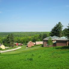
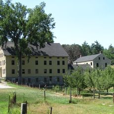
Harvard is a town in Worcester County, Massachusetts, situated across rolling terrain and agricultural areas. The community features residential neighborhoods interspersed with farmland, with the monastery serving as a notable landmark in the local landscape.

Founded in 1658 and officially incorporated in 1732, the town evolved from a farming settlement into an agricultural hub. Dairy farming became the economic foundation, making it a major milk-producing region in the early 20th century.

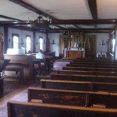
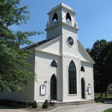
The Saint Benedict Abbey, a Catholic monastery, remains an important spiritual center that shapes the town's character. Visitors can experience the monastic presence that influences the rhythm and values of the local community.

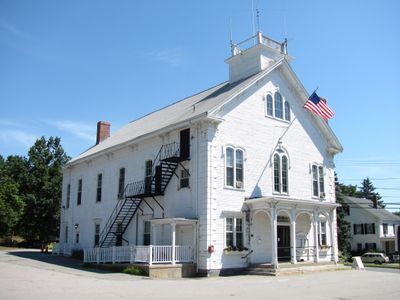
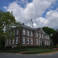
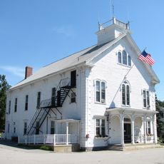
The town operates through an open town meeting system, allowing residents to participate directly in local governance. Visitors interested in seeing this democratic process in action can attend public meetings or explore the town hall.

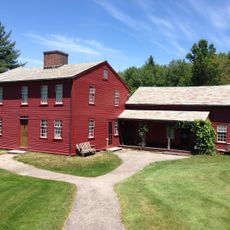
The site once hosted Fruitlands, a transcendentalist community established in 1843 that attracted visits from notable figures like Henry David Thoreau. This experimental settlement lasted only seven months but left a mark on American intellectual history.

The community of curious travelers

AroundUs brings together thousands of curated places, local tips, and hidden gems, enriched daily by 60,000 contributors worldwide.

Start exploring
Location
Inception
1658
Elevation above the sea
128 m
Shares border with
Ayer
GPS coordinates
42.50000,-71.58333
Latest update
December 20, 2025 16:16
Around this place
Fruitlands
United States of America

Fruitlands

2.6 km
Fruitlands Museum
United States of America

Fruitlands Museum

2.5 km
St. Benedict Abbey
United States of America

St. Benedict Abbey

3.4 km
Oxbow National Wildlife Refuge
United States of America

Oxbow National Wildlife Refuge

3.3 km
Oak Ridge Observatory
United States of America

Oak Ridge Observatory

2.1 km
Harvard Shaker Village Historic District
United States of America

Harvard Shaker Village Historic District

4.1 km
Still River Baptist Church
United States of America

Still River Baptist Church

3 km
Fort Devens Historic District
United States of America

Fort Devens Historic District

5.7 km
Frederick Fiske and Gretchen Osgood Warren House
United States of America

Frederick Fiske and Gretchen Osgood Warren House

1.2 km
Harvard Center Historic District
United States of America

Harvard Center Historic District

246 m
Carlson Orchards
United States of America

Carlson Orchards

1.8 km
United States of America

Bare Hill Pond

1.7 km
United States of America

U.S. Army Fort Devens Hodges Theater

5.2 km
Harvard Town Beach
United States of America

Harvard Town Beach

525 m
United States of America

Shaker Hills Country Club

5.4 km
United States of America

Red Tail Golf Course

3.8 km
United States of America

Cronin Auditorium

232 m
United States of America

Art Gallery

2.4 km
United States of America

Native American Gallery

2.4 km

Wayside Gallery

2.4 km
United States of America

Pumunangwet, He Who Soots the Stars

2.4 km
United States of America

Wo Peen, The Dreamer

2.4 km
United States of America

The Olympic Bell

4.6 km
United States of America

Old Frog Pond Farm & Studio

4.6 km
United States of America

Prospect House

2.3 km
United States of America

Statue, Work of art

112 m
United States of America

Scenic viewpoint

2.9 km
United States of America

Scenic viewpoint

4.9 km
Show the full map
« Harvard - Rural town in Worcester County, Massachusetts, US » is provided by Around Us (aroundus.com). Images and texts are derived from Wikimedia project under a Creative Commons license. You are allowed to copy, distribute, and modify copies of this page, under the conditions set by the license, as long as this note is clearly visible.

Discover hidden gems everywhere you go!

From secret cafés to breathtaking viewpoints, skip the crowded tourist spots and find places that match your style. Our app makes it easy with voice search, smart filtering, route optimization, and insider tips from travelers worldwide. Download now for the complete mobile experience.

Around Us App Screenshot

A unique approach to discovering new places

Le Figaro

All the places worth exploring

France Info

A tailor-made excursion in just a few clicks

20 Minutes

Around Us
Travel Guide & Maps
Download

Send to your phone

QR Code
1

Open the camera app on your mobile.

2

Point at the QR code with your camera. A notification will appear.

3

Tap the notification to open the link.