Chest opened
+${chestReward.xp} XP
Explorer
NOUVEAU ×${chestReward.collectible.quantity}
tapez pour fermer
Chest locked

Open chests in the app

Around Us is built for your phone — chests unlock when you walk, explore and capture nearby places.

Enable Location

We need your location to show you interesting places around you

Discover nearby places

Find interesting locations and hidden gems around you

Precise directions

Get accurate directions and distances to places

Your location is never shared with other users. It's only used when you tap the location button.

Muskingum River

Log in to your account

Start exploring — it's free

Trusted by 72,891 travelers worldwide

Continue with Google
Continue with Apple
or

We will send you a code to connect

By continuing, you accept our Terms and Conditions and our Privacy Policy

Check your inbox

We've sent a pincode in your inbox. Please enter the code below.

Muskingum River
Discussion Reviews 1 Photos
15.7k Popularity

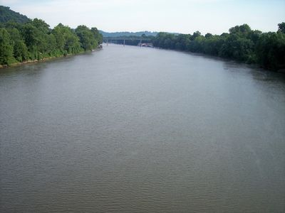
Muskingum River, River system in eastern Ohio, United States

The Muskingum River is a river system in eastern Ohio formed where two major waterways converge near Coshocton. The waterway flows southeast through the region until it joins the Ohio River near Marietta.

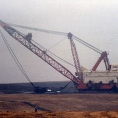
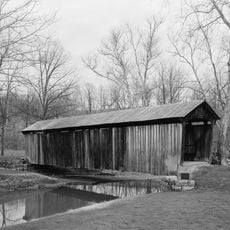
The river served as an important commercial route during the 1800s, and a system of locks and dams was built in the mid-20th century. This infrastructure permanently changed how the waterway functioned and opened new possibilities for its use.

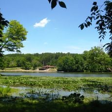
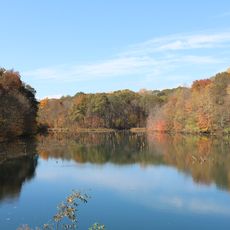
The river has long connected communities along its course and shaped how people settled in the region. Today, locals and visitors use the banks for recreation and outdoor activities.

The waterway has a series of locks and dams that allow recreational boats to travel its entire length. The river is surrounded by several parks and recreation areas that are easy to access.

The name comes from the Shawnee language and refers to the swampy ground that once characterized the landscape. This connection to Native American heritage remains visible today in regional place names.

The community of curious travelers

AroundUs brings together thousands of curated places, local tips, and hidden gems, enriched daily by 60,000 contributors worldwide.

Start exploring
GPS coordinates
39.76354,-81.89517
Latest update
December 7, 2025 19:29
Around this place
Big Muskie
United States of America

Big Muskie

15.8 km
The Wilds
United States of America

The Wilds

15.7 km
Y-Bridge
United States of America

Y-Bridge

22.2 km
Blue Rock State Park
United States of America

Blue Rock State Park

7.1 km
St. Thomas Aquinas Church
United States of America

St. Thomas Aquinas Church

22.1 km
Masonic Temple Building
United States of America

Masonic Temple Building

21.9 km
Muskingum County Courthouse
United States of America

Muskingum County Courthouse

21.9 km
Helmick Mill Covered Bridge
United States of America

Helmick Mill Covered Bridge

6.3 km
Perry State Forest
United States of America

Perry State Forest

26.9 km
United States Post Office and Federal Building
United States of America

United States Post Office and Federal Building

21.8 km
St. James Episcopal Church
United States of America

St. James Episcopal Church

22.1 km
St. John's Evangelical Lutheran Church
United States of America

St. John's Evangelical Lutheran Church

11.1 km
Alameda Apartments
United States of America

Alameda Apartments

22.2 km
Zanesville YWCA
United States of America

Zanesville YWCA

21.9 km
Adams Covered Bridge
United States of America

Adams Covered Bridge

19.5 km
James Boggs Tannehill House
United States of America

James Boggs Tannehill House

24.5 km
St. John's Lutheran Church
United States of America

St. John's Lutheran Church

21.9 km
Salt Creek Covered Bridge
United States of America

Salt Creek Covered Bridge

26.6 km
Adena Court Apartments
United States of America

Adena Court Apartments

21.8 km
West View
United States of America

West View

24.3 km
Ralph Hardesty Stone House
United States of America

Ralph Hardesty Stone House

26.3 km
Perry Wiles Grocery Company
United States of America

Perry Wiles Grocery Company

22 km
West Union School
United States of America

West Union School

22.2 km
William B. Harris House
United States of America

William B. Harris House

21.3 km
St. Nicholas' Catholic Church
United States of America

St. Nicholas' Catholic Church

21.6 km
Lafayette Lodge No. 79
United States of America

Lafayette Lodge No. 79

22.1 km
West School
United States of America

West School

17.8 km
National Road & Zane Grey Museum
United States of America

National Road & Zane Grey Museum

24.3 km
Show the full map
Reviews
Share your experience

No review yet

Discussions
Start a discussion...

No discussion yet

« Muskingum River - River system in eastern Ohio, United States » is provided by Around Us (aroundus.com). Images and texts are derived from Wikimedia project under a Creative Commons license. You are allowed to copy, distribute, and modify copies of this page, under the conditions set by the license, as long as this note is clearly visible.

Discover hidden gems everywhere you go!

From secret cafés to breathtaking viewpoints, skip the crowded tourist spots and find places that match your style. Our app makes it easy with voice search, smart filtering, route optimization, and insider tips from travelers worldwide. Download now for the complete mobile experience.

Around Us App Screenshot

A unique approach to discovering new places

Le Figaro

All the places worth exploring

France Info

A tailor-made excursion in just a few clicks

20 Minutes

Around Us
Travel Guide & Maps
Download

Send to your phone

QR Code
1

Open the camera app on your mobile.

2

Point at the QR code with your camera. A notification will appear.

3

Tap the notification to open the link.