Smithville, city in Tennessee, United States
Smithville is a small city in DeKalb County, Tennessee, situated on rolling terrain surrounded by forests and open spaces. An old courthouse anchors the town center, ringed by small shops and cafes, while quiet streets are lined with historic buildings that speak to generations of settlement.
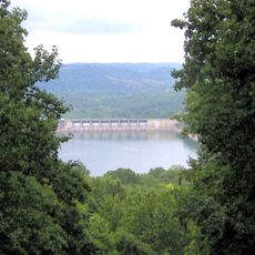
The town was founded in the early 1800s as a trading point along a road, with farming and small businesses sustaining the community for generations. Completion of the Center Hill Dam in 1949 marked a turning point, introducing new forms of activity and visitors to the region.
The town is rooted in bluegrass and folk music traditions, especially visible during the annual Fiddlers' Jamboree when musicians gather to play outdoors. Family-run shops and cafes around the historic courthouse reflect how the community values local connections and handmade crafts.
The town is best reached by car, with good road connections to larger cities like Nashville and Chattanooga nearby. Simple navigation and open parking around the center make it easy to explore shops, cafes, and the courthouse on foot.
Samuel Smith, the local leader for whom the town is named, shaped its early development, yet his influence often goes unnoticed in modern discussions of the place. Many visitors overlook that the town's founding was tied directly to early trade routes that made it a gathering point for the region.
The community of curious travelers
AroundUs brings together thousands of curated places, local tips, and hidden gems, enriched daily by 60,000 contributors worldwide.