·

Enable Location

We need your location to show you interesting places around you

Discover nearby places

Find interesting locations and hidden gems around you

Precise directions

Get accurate directions and distances to places

Your location is never shared with other users. It's only used when you tap the location button.

Center Hill Lake

Log in to your account

Start exploring — it's free

Trusted by 62,752 travelers worldwide

Continue with Google
Continue with Apple
or

We will send you a code to connect

By continuing, you accept our Terms and Conditions and our Privacy Policy

Check your inbox

We've sent a pincode in your inbox. Please enter the code below.

Center Hill Lake

Center Hill Lake, Reservoir in Middle Tennessee, US

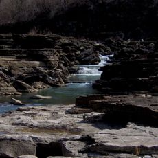
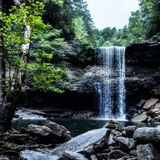
Center Hill Lake is a reservoir in Middle Tennessee spanning roughly 74 square kilometers with a shoreline extending about 668 kilometers. The water reaches depths of up to 58 meters in places and is surrounded by forested hills and small coves.

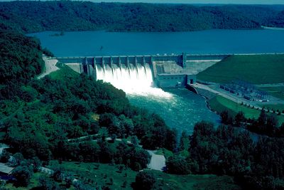
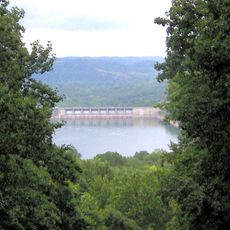
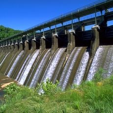
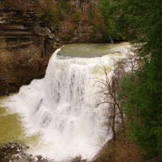
Congress authorized the dam construction in 1942 after Pearl Harbor to generate power for defense industries in the Southeast. Work began in the Forties and was completed in the Fifties, impounding the Caney Fork River.

The reservoir takes its name from nearby Center Hill, a tract of land that early settlers named for its central position in the region. Families come here to picnic along the wooded shores while anglers seek out favorite spots along its many coves.

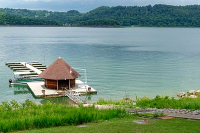
Several boat ramps such as Big Hurricane Creek and Cane Hollow offer water access and allow launching of watercraft. A few marinas along the shore rent out equipment and offer slips for longer stays.

The ecosystem here supports fish species including bass, walleye, and crappie that draw anglers from across the state. The branching shoreline offers quiet fishing spots often accessible only from the water.

The community of curious travelers

AroundUs brings together thousands of curated places, local tips, and hidden gems, enriched daily by 60,000 contributors worldwide.

Start exploring
Location
Inception
1942
GPS coordinates
36.09694,-85.82667
Latest update
December 5, 2025 22:29
Around this place
Cummins Falls State Park
United States of America

Cummins Falls State Park

29.3 km
Cummins Falls
United States of America

Cummins Falls

28.6 km
Burgess Falls State Park
United States of America

Burgess Falls State Park

21.7 km
Rock Island State Park
United States of America

Rock Island State Park

36.2 km
Edgar Evins State Park
United States of America

Edgar Evins State Park

2.5 km
Great Falls Dam
United States of America

Great Falls Dam

37.7 km
Tucker Stadium
United States of America

Tucker Stadium

30.2 km
Burgess Falls
United States of America

Burgess Falls

21.7 km
Fort Blount
United States of America

Fort Blount

25.6 km
White Plains
United States of America

White Plains

35.1 km
West End Church of Christ Silver Point
United States of America

West End Church of Christ Silver Point

8.9 km
Davis-Hull House
United States of America

Davis-Hull House

21.3 km
Sellars Indian Mound
United States of America

Sellars Indian Mound

38.1 km
United States of America

Beaver Dam Plantation

36.8 km
Cordell Hull Bridge
United States of America

Cordell Hull Bridge

20.4 km
Cullum Mansion
United States of America

Cullum Mansion

20.7 km
Cannon County Courthouse
United States of America

Cannon County Courthouse

37.1 km
Brevard-Macon House
United States of America

Brevard-Macon House

37.9 km
James Bradley House
United States of America

James Bradley House

33.6 km
Smith County Courthouse
United States of America

Smith County Courthouse

20.6 km
Broad Street Church of Christ
United States of America

Broad Street Church of Christ

28.9 km
Fite-Williams-Ligon House
United States of America

Fite-Williams-Ligon House

20.9 km
Liberty Historic District
United States of America

Liberty Historic District

16.2 km
Algood United Methodist Church
United States of America

Algood United Methodist Church

35.6 km
William Washington Seay House
United States of America

William Washington Seay House

28 km
Spring Creek Presbyterian Church
United States of America

Spring Creek Presbyterian Church

37.1 km
Community Building
United States of America

Community Building

37.8 km
Greater Falls
United States of America

Greater Falls

37 km
Show the full map
« Center Hill Lake - Reservoir in Middle Tennessee, US » is provided by Around Us (aroundus.com). Images and texts are derived from Wikimedia project under a Creative Commons license. You are allowed to copy, distribute, and modify copies of this page, under the conditions set by the license, as long as this note is clearly visible.

Discover hidden gems everywhere you go!

From secret cafés to breathtaking viewpoints, skip the crowded tourist spots and find places that match your style. Our app makes it easy with voice search, smart filtering, route optimization, and insider tips from travelers worldwide. Download now for the complete mobile experience.

Around Us App Screenshot

A unique approach to discovering new places

Le Figaro

All the places worth exploring

France Info

A tailor-made excursion in just a few clicks

20 Minutes

Around Us
Travel Guide & Maps
Download

Send to your phone

QR Code
1

Open the camera app on your mobile.

2

Point at the QR code with your camera. A notification will appear.

3

Tap the notification to open the link.