Chest opened
+${chestReward.xp} XP
Explorer
NOUVEAU ×${chestReward.collectible.quantity}
tapez pour fermer
Chest locked

Open chests in the app

Around Us is built for your phone — chests unlock when you walk, explore and capture nearby places.

Enable Location

We need your location to show you interesting places around you

Discover nearby places

Find interesting locations and hidden gems around you

Precise directions

Get accurate directions and distances to places

Your location is never shared with other users. It's only used when you tap the location button.

Tipp City

Log in to your account

Start exploring — it's free

Trusted by 72,882 travelers worldwide

Continue with Google
Continue with Apple
or

We will send you a code to connect

By continuing, you accept our Terms and Conditions and our Privacy Policy

Check your inbox

We've sent a pincode in your inbox. Please enter the code below.

Discussion Reviews 1 Photos
18.4k Popularity

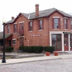
Tipp City, Administrative division in Miami County, Ohio, US

Tipp City is a city in Miami County, Ohio that stretches along Interstate 75 near the Interstate 70 interchange. The community is shaped by residential neighborhoods, light manufacturing facilities, and small businesses that define its everyday character.

The city was founded in 1840 along the Miami and Erie Canal under the name Tippecanoe City. It adopted its current name in 1938.

The annual Mum Festival in September and Canal Days in May draw residents together for community celebrations that reflect local traditions. These gatherings shape the rhythm of community life and show how the city values bringing people together.

The City Manager's Office at 260 S Garber Drive handles municipal services, billing questions, and local administrative matters for residents. The location along major interstate routes makes it easy for visitors and commuters to access the area.

A tornado on June 8, 2022 caused significant damage to a distribution center, marking a notable moment in the city's recent past. This event demonstrated the community's resilience as the area worked to rebuild.

The community of curious travelers

AroundUs brings together thousands of curated places, local tips, and hidden gems, enriched daily by 60,000 contributors worldwide.

Start exploring
Location
Inception
1840
Elevation above the sea
252 m
GPS coordinates
39.96390,-84.18360
Latest update
December 7, 2025 19:22
Around this place
Hara Arena
United States of America

Hara Arena

17.1 km
Dayton Aviation Heritage National Historical Park
United States of America

Dayton Aviation Heritage National Historical Park

20.5 km
Huffman Prairie
United States of America

Huffman Prairie

20.5 km
Boonshoft Museum of Discovery
United States of America

Boonshoft Museum of Discovery

19.6 km
Hobart Arena
United States of America

Hobart Arena

9.3 km
Eldean Covered Bridge
United States of America

Eldean Covered Bridge

13 km
St. Adalbert Polish Catholic Church
United States of America

St. Adalbert Polish Catholic Church

20.2 km
Holy Cross Lithuanian Roman Catholic Church
United States of America

Holy Cross Lithuanian Roman Catholic Church

20.4 km
Olive Branch High School
United States of America

Olive Branch High School

17 km
Miami County Courthouse
United States of America

Miami County Courthouse

8.8 km
Overfield Tavern
United States of America

Overfield Tavern

8.6 km
Dayton Fire Station No. 14
United States of America

Dayton Fire Station No. 14

20.8 km
Troy Public Square
United States of America

Troy Public Square

8.6 km
Casstown Lutheran Stone Church
United States of America

Casstown Lutheran Stone Church

10.7 km
Aullwood House and Garden
United States of America

Aullwood House and Garden

13.2 km
Arnold Homestead
United States of America

Arnold Homestead

12.6 km
Kroger Aquatic Center
United States of America

Kroger Aquatic Center

11.8 km
Ausenbaugh-McElhenny House
United States of America

Ausenbaugh-McElhenny House

13.4 km
John Minor Dye Stone House
United States of America

John Minor Dye Stone House

8.5 km
Huffman Prairie Flying Field Interpretive Center
United States of America

Huffman Prairie Flying Field Interpretive Center

20.6 km
Mercer Log House
United States of America

Mercer Log House

20.5 km
Halderman Museum Barn
United States of America

Halderman Museum Barn

10.2 km
WACO Air Museum & Aviation Learning Center
United States of America

WACO Air Museum & Aviation Learning Center

5.6 km
Fort Piqua Plaza
United States of America

Fort Piqua Plaza

21.1 km
United States of America

Paradigm Industrial

20.3 km
United States of America

Scene 75 Entertainment Center

14.1 km
United States of America

Ice Burge

16.8 km
United States of America

Scenic viewpoint

20.4 km
Show the full map
Reviews
Share your experience

No review yet

Discussions
Start a discussion...

No discussion yet

« Tipp City - Administrative division in Miami County, Ohio, US » is provided by Around Us (aroundus.com). Images and texts are derived from Wikimedia project under a Creative Commons license. You are allowed to copy, distribute, and modify copies of this page, under the conditions set by the license, as long as this note is clearly visible.

Discover hidden gems everywhere you go!

From secret cafés to breathtaking viewpoints, skip the crowded tourist spots and find places that match your style. Our app makes it easy with voice search, smart filtering, route optimization, and insider tips from travelers worldwide. Download now for the complete mobile experience.

Around Us App Screenshot

A unique approach to discovering new places

Le Figaro

All the places worth exploring

France Info

A tailor-made excursion in just a few clicks

20 Minutes

Around Us
Travel Guide & Maps
Download

Send to your phone

QR Code
1

Open the camera app on your mobile.

2

Point at the QR code with your camera. A notification will appear.

3

Tap the notification to open the link.