Enable Location

We need your location to show you interesting places around you

Discover nearby places

Find interesting locations and hidden gems around you

Precise directions

Get accurate directions and distances to places

Your location is never shared with other users. It's only used when you tap the location button.

Falls of the Ohio National Wildlife Conservation Area

Log in to your account

Start exploring — it's free

Trusted by 62,608 travelers worldwide

Continue with Google
Continue with Apple
or

We will send you a code to connect

By continuing, you accept our Terms and Conditions and our Privacy Policy

Check your inbox

We've sent a pincode in your inbox. Please enter the code below.

Falls of the Ohio National Wildlife Conservation Area

Falls of the Ohio National Wildlife Conservation Area, National Wildlife Conservation Area and Natural Landmark in Clarksville, Indiana.

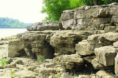
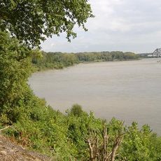
Falls of the Ohio is a protected conservation area spanning about 1,400 acres along the Ohio River near Clarksville, where visitors can see ancient fossilized seabeds. The riverbanks display limestone formations that hold remains of creatures from long ago.

The site served as a meeting point for explorers in the late 1700s and was later protected as a natural area. It marks a place where Indigenous cultures and European exploration paths crossed.

The visitor center shares stories about the fossils here and explains how Indigenous peoples and settlers lived in this area over centuries.

The best time to explore the fossil beds is between August and October when river water levels drop and rock formations are most visible. The grounds are easy to walk, and the visitor center provides helpful background before heading to the shoreline.

The limestone layers hold fossils of sea creatures that lived millions of years ago, including corals, shells, and ancient snails. This makes the place a window into a time when this region was a shallow, warm ocean.

The community of curious travelers

AroundUs brings together thousands of curated places, local tips, and hidden gems, enriched daily by 60,000 contributors worldwide.

Start exploring
Location
GPS coordinates
38.27660,-85.76540
Latest update
December 7, 2025 19:28
Around this place
Muhammad Ali Center
United States of America

Muhammad Ali Center

2.1 km
Louisville Slugger Museum & Factory
United States of America

Louisville Slugger Museum & Factory

2.2 km
Humana Building
United States of America

Humana Building

2.3 km
Abraham Lincoln Bridge
United States of America

Abraham Lincoln Bridge

2.3 km
Frazier History Museum
United States of America

Frazier History Museum

2.1 km
George Rogers Clark Memorial Bridge
United States of America

George Rogers Clark Memorial Bridge

1.9 km
Colgate Clock
United States of America

Colgate Clock

1.1 km
The Kentucky Center
United States of America

The Kentucky Center

2.2 km
Kentucky Science Center
United States of America

Kentucky Science Center

2.1 km
Fourteenth Street Bridge
United States of America

Fourteenth Street Bridge

805 m
32nd Indiana Monument
United States of America

32nd Indiana Monument

2.1 km
Mayor Andrew Broaddus
United States of America

Mayor Andrew Broaddus

2.1 km
Derby Dinner Playhouse
United States of America

Derby Dinner Playhouse

1 km
United States Marine Hospital of Louisville
United States of America

United States Marine Hospital of Louisville

1.7 km
Portland Museum
United States of America

Portland Museum

2 km
Proof on Main
United States of America

Proof on Main

2.2 km
Columbia Building
United States of America

Columbia Building

2.3 km
St. Patrick's Roman Catholic Church, Rectory, and School
United States of America

St. Patrick's Roman Catholic Church, Rectory, and School

2.2 km
Warder Park
United States of America

Warder Park

2 km
Montgomery Street School
United States of America

Montgomery Street School

2.1 km
Grisamore House
United States of America

Grisamore House

2.2 km
Theodore Roosevelt Elementary School
United States of America

Theodore Roosevelt Elementary School

2 km
Kenyon Building
United States of America

Kenyon Building

2.3 km
National Tobacco Works Branch Stemmery
United States of America

National Tobacco Works Branch Stemmery

2.2 km
Old Clarksville Site
United States of America

Old Clarksville Site

1.5 km
KMAC Museum
United States of America

KMAC Museum

2.2 km
Jeffersonville Township Public Library
United States of America

Jeffersonville Township Public Library

2.2 km
Louisville Glassworks
United States of America

Louisville Glassworks

2.3 km
Show the full map
« Falls of the Ohio National Wildlife Conservation Area - National Wildlife Conservation Area and Natural Landmark in Clarksville, Indiana » is provided by Around Us (aroundus.com). Images and texts are derived from Wikimedia project under a Creative Commons license. You are allowed to copy, distribute, and modify copies of this page, under the conditions set by the license, as long as this note is clearly visible.

Discover hidden gems everywhere you go!

From secret cafés to breathtaking viewpoints, skip the crowded tourist spots and find places that match your style. Our app makes it easy with voice search, smart filtering, route optimization, and insider tips from travelers worldwide. Download now for the complete mobile experience.

Around Us App Screenshot

A unique approach to discovering new places

Le Figaro

All the places worth exploring

France Info

A tailor-made excursion in just a few clicks

20 Minutes

Around Us
Travel Guide & Maps
Download

Send to your phone

QR Code
1

Open the camera app on your mobile.

2

Point at the QR code with your camera. A notification will appear.

3

Tap the notification to open the link.