Allegheny River Turnpike Bridge

Log in to your account

AroundUs is a community-driven map of interesting places, built by curious explorers like you. It grows with every review, story, and photo you share.
Connect to save your favorite spots, contribute locations, and create personalized routes.
Continue with Google
Continue with Apple
Continue with X
Continue with Facebook
Continue with email
By continuing, you accept our Terms and Conditions and our Privacy Policy
Create an account

Allegheny River Turnpike Bridge

Add to collection
Map
Suggest a change
Share

Allegheny River Turnpike Bridge, Highway bridge in Cheswick, Pennsylvania, United States

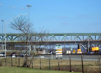
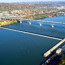
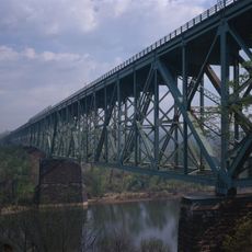
The Allegheny River Turnpike Bridge is a highway bridge consisting of twin concrete structures spanning the river and carrying Interstate 76 traffic between the communities on either side. The newer bridge replaced an older structure that once served the same crossing point.

An original bridge was built between 1949 and 1951, predating the Interstate System by many years and serving the region before major highway expansion. A newer structure was constructed in the following decade to handle increased traffic demands and provide better roadway standards.

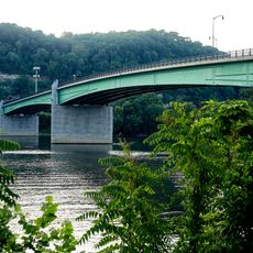
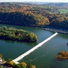
The bridge connects communities on both sides of the river and has shaped how people move through this part of Pennsylvania. It remains a working part of daily life for countless travelers passing through the region.

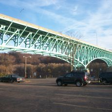
The bridge is open to traffic around the clock and features multiple lanes in each direction with separate access and exit ramps for smooth flow. Drivers should expect typical highway conditions and plan for busy traffic times during commuting periods.

The bridge employs a specialized construction technique called balanced cantilever design, which allows sections to extend and support themselves without temporary supports during building. Stone detailing on the bridge piers echoes the natural rock formations found throughout the surrounding Pennsylvania landscape.

Location: Pennsylvania

Official opening: November 2009

GPS coordinates: 40.53730,-79.82220

Latest update: December 13, 2025 12:42

Photos
Around this place
Oakmont Country Club
United States of America

Oakmont Country Club

1.3 km
Pittsburgh Zoo & Aquarium
United States of America

Pittsburgh Zoo & Aquarium

10 km
Sri Venkateswara Temple
United States of America

Sri Venkateswara Temple

10.8 km
Hartwood Acres Park
United States of America

Hartwood Acres Park

8.7 km
Allegheny Islands State Park
United States of America

Allegheny Islands State Park

589 m
National Negro Opera Company
United States of America

National Negro Opera Company

10.2 km
Bayernhof Music Museum
United States of America

Bayernhof Music Museum

9 km
Highland Park Bridge
United States of America

Highland Park Bridge

9.3 km
Rachel Carson Homestead
United States of America

Rachel Carson Homestead

3.4 km
Sauer Buildings Historic District
United States of America

Sauer Buildings Historic District

8.3 km
Jonathon Hulton Bridge
United States of America

Jonathon Hulton Bridge

2.4 km
Allegheny River Lock and Dam No. 2
United States of America

Allegheny River Lock and Dam No. 2

9.4 km
Bessemer & Lake Erie Railroad Bridge
United States of America

Bessemer & Lake Erie Railroad Bridge

115 m
Allegheny River Lock and Dam No. 3
United States of America

Allegheny River Lock and Dam No. 3

597 m
Beulah Presbyterian Church
United States of America

Beulah Presbyterian Church

10.3 km
Brilliant Branch Railroad Bridge
United States of America

Brilliant Branch Railroad Bridge

9 km
George D. Stuart Bridge
United States of America

George D. Stuart Bridge

8.7 km
New Kensington Downtown Historic District
United States of America

New Kensington Downtown Historic District

5.7 km
Wyckoff-Mason House
United States of America

Wyckoff-Mason House

5.2 km
Valley Sports Complex
United States of America

Valley Sports Complex

8.4 km
New Kensington Production Works Historic District
United States of America

New Kensington Production Works Historic District

5.4 km
Dr. Thomas R. Kerr House and Office
United States of America

Dr. Thomas R. Kerr House and Office

2.7 km
Horse Tamer Sculptures
United States of America

Horse Tamer Sculptures

10.2 km
Logans Ferry Powder Works Historic District
United States of America

Logans Ferry Powder Works Historic District

4.8 km
Welcome Sculptures
United States of America

Welcome Sculptures

10.3 km
Old Highland Park Bridge
United States of America

Old Highland Park Bridge

9.7 km
University of Pittsburgh Applied Research Center
United States of America

University of Pittsburgh Applied Research Center

1 km
Heth's Run Bridge
United States of America

Heth's Run Bridge

9.9 km
Show the full map
Reviews

Visited this place? Tap the stars to rate it and share your experience / photos with the community! Try now! You can cancel it anytime.

« Allegheny River Turnpike Bridge - Highway bridge in Cheswick, Pennsylvania, United States » is provided by Around Us (aroundus.com). Images and texts are derived from Wikimedia project under a Creative Commons license. You are allowed to copy, distribute, and modify copies of this page, under the conditions set by the license, as long as this note is clearly visible.

Discover hidden gems everywhere you go!

From secret cafés to breathtaking viewpoints, skip the crowded tourist spots and find places that match your style. Our app makes it easy with voice search, smart filtering, route optimization, and insider tips from travelers worldwide. Download now for the complete mobile experience.

Around Us App Screenshot

A unique approach to discovering new places

Le Figaro

All the places worth exploring

France Info

A tailor-made excursion in just a few clicks

20 Minutes