Chest opened
+${chestReward.xp} XP
Explorer
NOUVEAU ×${chestReward.collectible.quantity}
tapez pour fermer
Chest locked

Open chests in the app

Around Us is built for your phone — chests unlock when you walk, explore and capture nearby places.

Enable Location

We need your location to show you interesting places around you

Discover nearby places

Find interesting locations and hidden gems around you

Precise directions

Get accurate directions and distances to places

Your location is never shared with other users. It's only used when you tap the location button.

Log in to your account

Start exploring — it's free

Trusted by 72,886 travelers worldwide

Continue with Google
Continue with Apple
or

We will send you a code to connect

By continuing, you accept our Terms and Conditions and our Privacy Policy

Check your inbox

We've sent a pincode in your inbox. Please enter the code below.

Beaver Lake
Discussion Reviews Photo
2.2k Popularity

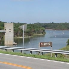
Beaver Lake, lake in Anderson County, Kentucky, United States

Beaver Lake is a reservoir in Anderson County, Kentucky, created by damming Beaver Creek near Lawrenceburg. The 146-acre body of water features a mix of open water and wooded shoreline, with a large fishing pier and boat ramp providing access to the lake.

The lake opened to the public in 1964 and has served as a fishing destination ever since. Management efforts intensified starting in 2011, introducing habitat improvements and regular fish stocking to maintain healthy populations.

The lake takes its name from Beaver Creek, the stream that was dammed to create it. Today it serves as a gathering place for local fishermen and families seeking a quiet outdoor retreat from nearby towns.

The boat ramp and fishing pier are free to use with ample parking available. Small motorboats under 10 horsepower can operate at normal speeds, while larger motors are restricted to slow-speed operation to protect the shoreline and water quality.

The lake uses an online map that shows anglers exactly where habitat structures like brush piles and submerged trees are positioned throughout the water. This tool helps fishermen locate productive spots and understand how the lake is actively managed for better fishing.

The community of curious travelers

AroundUs brings together thousands of curated places, local tips, and hidden gems, enriched daily by 60,000 contributors worldwide.

Start exploring
Location
Elevation above the sea
239 m
GPS coordinates
37.96360,-85.02240
Latest update
February 15, 2026 11:30
Around this place
Old Fort Harrod State Park
United States of America

Old Fort Harrod State Park

27.1 km
Young's High Bridge
United States of America

Young's High Bridge

17.7 km
Floral clock
United States of America

Floral clock

27.9 km
Taylorsville Lake State Park
United States of America

Taylorsville Lake State Park

21.8 km
Rocky Point Manor
United States of America

Rocky Point Manor

27.3 km
Confederate Monument in Lawrenceburg
United States of America

Confederate Monument in Lawrenceburg

13.7 km
Berry Mansion
United States of America

Berry Mansion

27.9 km
Mount Zion Covered Bridge
United States of America

Mount Zion Covered Bridge

25.5 km
Cleveland House
United States of America

Cleveland House

27.3 km
T. B. Ripy House
United States of America

T. B. Ripy House

13.5 km
Newell B. McClaskey House
United States of America

Newell B. McClaskey House

22.3 km
Confederate Monument in Harrodsburg
United States of America

Confederate Monument in Harrodsburg

27 km
Confederate Monument in Versailles
United States of America

Confederate Monument in Versailles

27.4 km
Beriah Magoffin Monument
United States of America

Beriah Magoffin Monument

27 km
New Providence Presbyterian Church
United States of America

New Providence Presbyterian Church

18.5 km
St. Peter's AME Church
United States of America

St. Peter's AME Church

27.3 km
St. Philip's Episcopal Church
United States of America

St. Philip's Episcopal Church

27.5 km
Big Spring Church
United States of America

Big Spring Church

26.9 km
Willisburg Historic District
United States of America

Willisburg Historic District

19.5 km
Farmer's Bank of Mackville
United States of America

Farmer's Bank of Mackville

26.5 km
Dowling House
United States of America

Dowling House

13.6 km
Carter House
United States of America

Carter House

27.4 km
Robertson House
United States of America

Robertson House

22.7 km
Cardwellton
United States of America

Cardwellton

27.3 km
Thomas H. Hanks House
United States of America

Thomas H. Hanks House

14.6 km
Rev. William Dudley Moore House
United States of America

Rev. William Dudley Moore House

13.1 km
Dr. Nash House
United States of America

Dr. Nash House

26.6 km
Capital Bowl
United States of America

Capital Bowl

23.2 km
Show the full map
Reviews
Share your experience

No review yet

Discussions
Start a discussion...

No discussion yet

« Beaver Lake - lake in Anderson County, Kentucky, United States » is provided by Around Us (aroundus.com). Images and texts are derived from Wikimedia project under a Creative Commons license. You are allowed to copy, distribute, and modify copies of this page, under the conditions set by the license, as long as this note is clearly visible.

Discover hidden gems everywhere you go!

From secret cafés to breathtaking viewpoints, skip the crowded tourist spots and find places that match your style. Our app makes it easy with voice search, smart filtering, route optimization, and insider tips from travelers worldwide. Download now for the complete mobile experience.

Around Us App Screenshot

A unique approach to discovering new places

Le Figaro

All the places worth exploring

France Info

A tailor-made excursion in just a few clicks

20 Minutes

Around Us
Travel Guide & Maps
Download

Send to your phone

QR Code
1

Open the camera app on your mobile.

2

Point at the QR code with your camera. A notification will appear.

3

Tap the notification to open the link.