Enable Location

We need your location to show you interesting places around you

Discover nearby places

Find interesting locations and hidden gems around you

Precise directions

Get accurate directions and distances to places

Your location is never shared with other users. It's only used when you tap the location button.

Bloomington Viaduct

Log in to your account

Start exploring — it's free

Trusted by 62,384 travelers worldwide

Continue with Google
Continue with Apple
or

We will send you a code to connect

By continuing, you accept our Terms and Conditions and our Privacy Policy

Check your inbox

We've sent a pincode in your inbox. Please enter the code below.

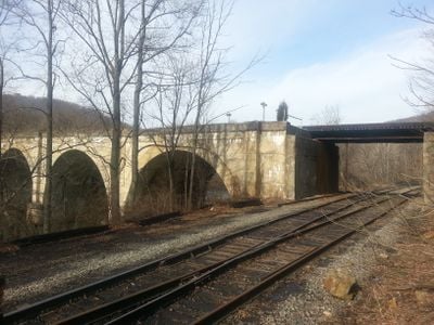
Bloomington Viaduct, stone arch railroad bridge spanning the Northern Branch of the Potomac River

The Bloomington Viaduct is a railway bridge with a deck arch design that spans the Northern Branch of the Potomac River between West Virginia and Maryland. The structure features three main stone arches, each spanning about 56 feet, with concrete additions made to accommodate additional tracks.

Built in 1851 as part of the Baltimore and Ohio Railroad, the viaduct was crucial for transporting coal and timber from mining regions to wider markets. In 1916, it was widened to carry four tracks instead of two, and it survived a Civil War attack in 1864 despite the regional conflict.

The name comes from the nearby town of Bloomington and reflects the railroad's role in linking two states and communities. For generations, locals watched trains cross here, making the bridge a visible symbol of the region's commitment to transportation and economic development.

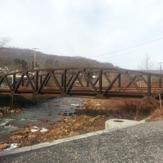
The viaduct is not open to public foot traffic but can be viewed from nearby walking trails and the river area at a safe distance. Visitors should stay in designated viewing areas and be aware that active freight trains still use this line today.

The viaduct is possibly the only bridge of its type in Garrett County and demonstrates an innovative arch design from the 1850s. The blend of original sandstone and later-added concrete shows how the structure was adapted to meet modern demands while preserving its historical form.

The community of curious travelers

AroundUs brings together thousands of curated places, local tips, and hidden gems, enriched daily by 60,000 contributors worldwide.

Start exploring
Location
Location
Architects
Baltimore and Ohio Railroad
Official opening
1851
Made from material
sandstone, concrete
GPS coordinates
39.47720,-79.06810
Latest update
February 9, 2026 07:42
Around this place
Deep Creek Lake
United States of America

Deep Creek Lake

28 km
Deep Creek Lake State Park
United States of America

Deep Creek Lake State Park

21 km
Sloan–Parker House
United States of America

Sloan–Parker House

26.2 km
Dans Mountain
United States of America

Dans Mountain

18.7 km
Casselman Bridge
United States of America

Casselman Bridge

25.3 km
Fort Ashby
United States of America

Fort Ashby

26.2 km
Stone Cottage
United States of America

Stone Cottage

16.8 km
Big Run State Park
United States of America

Big Run State Park

9.6 km
Savage River Reservoir
United States of America

Savage River Reservoir

6.4 km
La Vale Tollgate House
United States of America

La Vale Tollgate House

25.8 km
Pennington Cottage
United States of America

Pennington Cottage

23.7 km
Deep Creek Lake State Park
United States of America

Deep Creek Lake State Park

20.7 km
Waverly Street Bridge
United States of America

Waverly Street Bridge

2.6 km
Mountain Lake Park Historic District
United States of America

Mountain Lake Park Historic District

28.4 km
Thomas R. Carskadon House
United States of America

Thomas R. Carskadon House

8.6 km
Fuller-Baker Log House
United States of America

Fuller-Baker Log House

25.9 km
Travelers Rest
United States of America

Travelers Rest

17.2 km
Anderson Chapel
United States of America

Anderson Chapel

14.1 km
Stanton's Mill
United States of America

Stanton's Mill

25.1 km
Shaw Mansion
United States of America

Shaw Mansion

8.9 km
Henry Glassaway Davis House
United States of America

Henry Glassaway Davis House

1.7 km
Lonaconing Historic District
United States of America

Lonaconing Historic District

12.8 km
Carskadon House
United States of America

Carskadon House

21.1 km
Burlington Historic District
United States of America

Burlington Historic District

20.3 km
New Germany State Park
United States of America

New Germany State Park

18 km
Mineral County Courthouse
United States of America

Mineral County Courthouse

9.1 km
James Drane House
United States of America

James Drane House

27 km
Frostburg Cinemas 1-2-3
United States of America

Frostburg Cinemas 1-2-3

23.2 km
Show the full map
« Bloomington Viaduct - stone arch railroad bridge spanning the Northern Branch of the Potomac River » is provided by Around Us (aroundus.com). Images and texts are derived from Wikimedia project under a Creative Commons license. You are allowed to copy, distribute, and modify copies of this page, under the conditions set by the license, as long as this note is clearly visible.

Discover hidden gems everywhere you go!

From secret cafés to breathtaking viewpoints, skip the crowded tourist spots and find places that match your style. Our app makes it easy with voice search, smart filtering, route optimization, and insider tips from travelers worldwide. Download now for the complete mobile experience.

Around Us App Screenshot

A unique approach to discovering new places

Le Figaro

All the places worth exploring

France Info

A tailor-made excursion in just a few clicks

20 Minutes

Around Us
Travel Guide & Maps
Download

Send to your phone

QR Code
1

Open the camera app on your mobile.

2

Point at the QR code with your camera. A notification will appear.

3

Tap the notification to open the link.