Enable Location

We need your location to show you interesting places around you

Discover nearby places

Find interesting locations and hidden gems around you

Precise directions

Get accurate directions and distances to places

Your location is never shared with other users. It's only used when you tap the location button.

Savage River Reservoir

Log in to your account

Start exploring — it's free

Trusted by 62,384 travelers worldwide

Continue with Google
Continue with Apple
or

We will send you a code to connect

By continuing, you accept our Terms and Conditions and our Privacy Policy

Check your inbox

We've sent a pincode in your inbox. Please enter the code below.

Savage River Reservoir

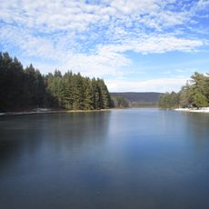
Savage River Reservoir, body of water

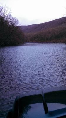
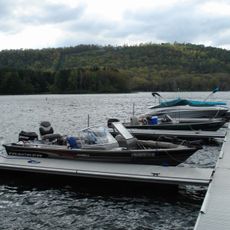
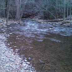
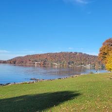
Savage River Reservoir is a 360-acre lake in Garrett County, Maryland, surrounded by forests and rocky shores with calm, clear water. The shoreline features tall trees and dense vegetation, with two main boat launch points and fluctuating water levels that change the appearance of the landscape.

The reservoir was built in 1952 to control floods and supply water to the town of Westernport. It was created by damming the Savage River and is operated by the Upper Potomac River Commission, playing an important role in water management for the region.

The name comes from the Savage River, the waterway that feeds it. Visitors can watch how anglers, paddlers, and campers use the water and surrounding forests as a place to step away from daily routines.

The area has two boat ramps for launching kayaks and boats that can be rocky or muddy, so check water levels before entering. Several campsites sit in nearby forests, many spread far apart for privacy, and this region receives frequent rain so pack rain gear.

Ice fishing is possible in winter but the ice can be unsafe as water levels can drop suddenly and freeze unpredictably. Bald eagles sometimes glide low over the water, and submerged willows and rock formations along the floor serve as feeding and shelter spots that visitors occasionally spot from the surface.

The community of curious travelers

AroundUs brings together thousands of curated places, local tips, and hidden gems, enriched daily by 60,000 contributors worldwide.

Start exploring
Location
GPS coordinates
39.50720,-79.13220
Latest update
February 9, 2026 08:22
Around this place
Deep Creek Lake
United States of America

Deep Creek Lake

22.2 km
Swallow Falls State Park
United States of America

Swallow Falls State Park

25.2 km
Deep Creek Lake State Park
United States of America

Deep Creek Lake State Park

15 km
Dans Mountain
United States of America

Dans Mountain

21.8 km
Casselman Bridge
United States of America

Casselman Bridge

21.1 km
Stone Cottage
United States of America

Stone Cottage

21 km
Big Run State Park
United States of America

Big Run State Park

4.2 km
Pennington Cottage
United States of America

Pennington Cottage

19.8 km
Deep Creek Lake State Park
United States of America

Deep Creek Lake State Park

14.6 km
Bloomington Viaduct
United States of America

Bloomington Viaduct

6.4 km
Waverly Street Bridge
United States of America

Waverly Street Bridge

7.9 km
Oakland Historic District
United States of America

Oakland Historic District

25.9 km
Mountain Lake Park Historic District
United States of America

Mountain Lake Park Historic District

24.7 km
Thomas R. Carskadon House
United States of America

Thomas R. Carskadon House

15 km
Garrett County Courthouse
United States of America

Garrett County Courthouse

26.1 km
Fuller-Baker Log House
United States of America

Fuller-Baker Log House

21.3 km
Travelers Rest
United States of America

Travelers Rest

22.9 km
Anderson Chapel
United States of America

Anderson Chapel

10 km
Stanton's Mill
United States of America

Stanton's Mill

21 km
Creedmore
United States of America

Creedmore

24.7 km
Shaw Mansion
United States of America

Shaw Mansion

11.4 km
Henry Glassaway Davis House
United States of America

Henry Glassaway Davis House

7.6 km
Lonaconing Historic District
United States of America

Lonaconing Historic District

14.9 km
Arrowhead Market
United States of America

Arrowhead Market

16.6 km
New Germany State Park
United States of America

New Germany State Park

14.1 km
Mineral County Courthouse
United States of America

Mineral County Courthouse

15.6 km
James Drane House
United States of America

James Drane House

20.6 km
Frostburg Cinemas 1-2-3
United States of America

Frostburg Cinemas 1-2-3

24.6 km
Show the full map
« Savage River Reservoir - body of water » is provided by Around Us (aroundus.com). Images and texts are derived from Wikimedia project under a Creative Commons license. You are allowed to copy, distribute, and modify copies of this page, under the conditions set by the license, as long as this note is clearly visible.

Discover hidden gems everywhere you go!

From secret cafés to breathtaking viewpoints, skip the crowded tourist spots and find places that match your style. Our app makes it easy with voice search, smart filtering, route optimization, and insider tips from travelers worldwide. Download now for the complete mobile experience.

Around Us App Screenshot

A unique approach to discovering new places

Le Figaro

All the places worth exploring

France Info

A tailor-made excursion in just a few clicks

20 Minutes

Around Us
Travel Guide & Maps
Download

Send to your phone

QR Code
1

Open the camera app on your mobile.

2

Point at the QR code with your camera. A notification will appear.

3

Tap the notification to open the link.