Enable Location

We need your location to show you interesting places around you

Discover nearby places

Find interesting locations and hidden gems around you

Precise directions

Get accurate directions and distances to places

Your location is never shared with other users. It's only used when you tap the location button.

Swallow Falls State Park

Log in to your account

Start exploring — it's free

Trusted by 62,827 travelers worldwide

Continue with Google
Continue with Apple
or

We will send you a code to connect

By continuing, you accept our Terms and Conditions and our Privacy Policy

Check your inbox

We've sent a pincode in your inbox. Please enter the code below.

Swallow Falls State Park, Woodland state park with waterfalls in Garrett County, United States

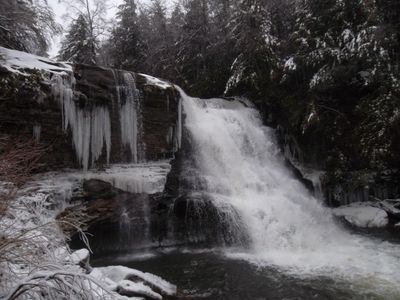
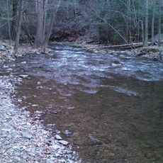
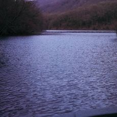
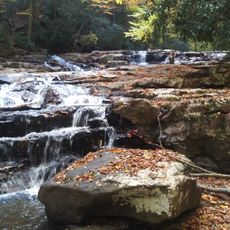
Swallow Falls State Park is a woodland reserve in Garrett County featuring multiple waterfalls along the Youghiogheny River. The park encompasses about 500 acres and includes Muddy Creek Falls, one of the region's most notable cascades.

The land was donated in 1906 by John and Robert Garrett, establishing the foundation for the park. During the 1930s, the Civilian Conservation Corps developed the site, creating trails and facilities that visitors still use today.

Thomas Edison, Henry Ford, and Harvey Firestone selected Muddy Creek Falls as their camping location during their Maryland explorations in 1918 and 1921.

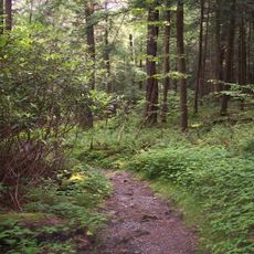
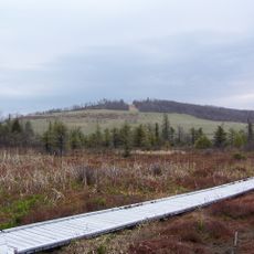
The park provides over 60 camping sites and various trails through the woodland. A longer route connects this location to a neighboring state park, allowing for extended hiking options.

The park protects one of Maryland's last old-growth hemlock forests, with trees exceeding 300 years in age. These ancient woodlands create a dark, cool forest environment that feels distinctly different from surrounding areas.

The community of curious travelers

AroundUs brings together thousands of curated places, local tips, and hidden gems, enriched daily by 60,000 contributors worldwide.

Start exploring
Location
Operator
Maryland Park Service
GPS coordinates
39.49670,-79.42530
Latest update
December 6, 2025 16:02
Places to discover in Maryland: coast lighthouses, wildlife sanctuaries, waterfalls, and gardens

Maryland has many places to see away from the usual crowds. Natural areas fill the state: sanctuaries where birds and mammals live, waterfalls carving through forests, and coastlines with calm views over the water. History is everywhere: white lighthouses that guided ships for centuries, colonial...

Around this place
Deep Creek Lake
United States of America

Deep Creek Lake

3.3 km
Deep Creek Lake State Park
United States of America

Deep Creek Lake State Park

10.8 km
Cathedral State Park
United States of America

Cathedral State Park

21.3 km
West Virginia Zoo
United States of America

West Virginia Zoo

27.1 km
Cranesville Swamp Preserve
United States of America

Cranesville Swamp Preserve

6.2 km
Big Run State Park
United States of America

Big Run State Park

25.3 km
Savage River Reservoir
United States of America

Savage River Reservoir

25.2 km
Potomac-Garrett State Forest
United States of America

Potomac-Garrett State Forest

2.8 km
Virginia Furnace
United States of America

Virginia Furnace

18.2 km
James S. Lakin House
United States of America

James S. Lakin House

12.1 km
Pennington Cottage
United States of America

Pennington Cottage

11.6 km
Deep Creek Lake State Park
United States of America

Deep Creek Lake State Park

11.1 km
Oakland Historic District
United States of America

Oakland Historic District

9.8 km
Terra Alta Bank
United States of America

Terra Alta Bank

11.9 km
Mountain Lake Park Historic District
United States of America

Mountain Lake Park Historic District

11.7 km
Garrett County Courthouse
United States of America

Garrett County Courthouse

10.1 km
Anderson Chapel
United States of America

Anderson Chapel

17.2 km
Old Hemlock
United States of America

Old Hemlock

23.6 km
Creedmore
United States of America

Creedmore

11.4 km
Brookside Historic District
United States of America

Brookside Historic District

21.2 km
Bayard Bridge
United States of America

Bayard Bridge

25.2 km
James Clark McGrew House
United States of America

James Clark McGrew House

22.6 km
Gaymont
United States of America

Gaymont

21.3 km
United States of America

Gormania Presbyterian Church

23.7 km
Downtown Rowlesburg Historic District
United States of America

Downtown Rowlesburg Historic District

26.9 km
Mercy Chapel at Mill Run
United States of America

Mercy Chapel at Mill Run

24.5 km
Kingwood Historic District
United States of America

Kingwood Historic District

22.7 km
James Drane House
United States of America

James Drane House

17.6 km
Show the full map
« Swallow Falls State Park - Woodland state park with waterfalls in Garrett County, United States » is provided by Around Us (aroundus.com). Images and texts are derived from Wikimedia project under a Creative Commons license. You are allowed to copy, distribute, and modify copies of this page, under the conditions set by the license, as long as this note is clearly visible.

Discover hidden gems everywhere you go!

From secret cafés to breathtaking viewpoints, skip the crowded tourist spots and find places that match your style. Our app makes it easy with voice search, smart filtering, route optimization, and insider tips from travelers worldwide. Download now for the complete mobile experience.

Around Us App Screenshot

A unique approach to discovering new places

Le Figaro

All the places worth exploring

France Info

A tailor-made excursion in just a few clicks

20 Minutes

Around Us
Travel Guide & Maps
Download

Send to your phone

QR Code
1

Open the camera app on your mobile.

2

Point at the QR code with your camera. A notification will appear.

3

Tap the notification to open the link.