Enable Location

We need your location to show you interesting places around you

Discover nearby places

Find interesting locations and hidden gems around you

Precise directions

Get accurate directions and distances to places

Your location is never shared with other users. It's only used when you tap the location button.

Cathedral State Park

Log in to your account

Start exploring — it's free

Trusted by travelers worldwide

Continue with Google
Continue with Apple
or

We will send you a code to connect

By continuing, you accept our Terms and Conditions and our Privacy Policy

Check your inbox

We've sent a pincode in your inbox. Please enter the code below.

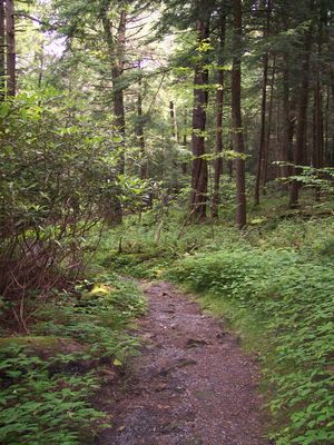
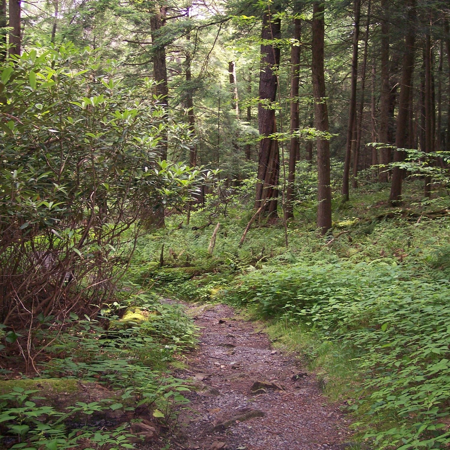
Cathedral State Park, Ancient hemlock forest in Aurora, West Virginia, US.

Description

Cathedral State Park is a nature preserve in West Virginia featuring an old-growth hemlock forest spread across 133 acres. The woodland contains over 170 tree and plant species, with some hemlocks reaching heights exceeding 90 feet.

History

A hotel worker named Branson Haas purchased the land in 1922 and later sold it to West Virginia in 1942 with the condition to preserve the forest. The state government later recognized its ecological value by granting it National Natural Landmark status in 1965.

Culture

The name comes from the cathedral-like hall created by towering hemlocks rising like columns through the forest. Visitors come to experience this natural architecture and walk beneath the dense canopy that filters sunlight into a hushed, sheltered space.

Practical

The park offers six miles of hiking trails suitable for different fitness levels and is easily reached via Route 50 in Preston County. Picnic shelters, tables, and restroom facilities are available throughout the property, allowing visitors to spend a full day comfortably.

Did you know?

The forest stands as the largest surviving old-growth woodland in West Virginia, with trees that are several centuries old. These undisturbed hemlock stands have become rare in the region and allow visitors to see what the landscape looked like before European settlement.

Location
Inception
1942
Elevation above the sea
768 m
GPS coordinates
39.32670,-79.53810
Latest update
December 8, 2025 19:49

AroundUs brings together thousands of curated places, local tips, and hidden gems, enriched daily by 60,000 contributors worldwide. Discover all places nearby (West Virginia).

Around this place
Deep Creek Lake
United States of America

Deep Creek Lake

24 km
Hoye-Crest
United States of America

Hoye-Crest

10.9 km
Blackwater Falls
United States of America

Blackwater Falls

24.5 km
Swallow Falls State Park
United States of America

Swallow Falls State Park

21.3 km
Fairfax Stone State Park
United States of America

Fairfax Stone State Park

15.3 km
Elakala Falls
United States of America

Elakala Falls

24.7 km
Cranesville Swamp Preserve
United States of America

Cranesville Swamp Preserve

23.3 km
Olson Observation Tower
United States of America

Olson Observation Tower

25.1 km
Virginia Furnace
United States of America

Virginia Furnace

24 km
James S. Lakin House
United States of America

James S. Lakin House

13 km
Pennington Cottage
United States of America

Pennington Cottage

20.5 km
Herman August Meyer House
United States of America

Herman August Meyer House

22.8 km
Potomac-Garrett State Forest
United States of America

Potomac-Garrett State Forest

19.7 km
Oakland Historic District
United States of America

Oakland Historic District

14.7 km
Terra Alta Bank
United States of America

Terra Alta Bank

13.2 km
Mountain Lake Park Historic District
United States of America

Mountain Lake Park Historic District

15.6 km
Garrett County Courthouse
United States of America

Garrett County Courthouse

14.4 km
Creedmore
United States of America

Creedmore

15.6 km
Brookside Historic District
United States of America

Brookside Historic District

285 m
Cottrill Opera House
United States of America

Cottrill Opera House

19.9 km
Bayard Bridge
United States of America

Bayard Bridge

15.6 km
James Clark McGrew House
United States of America

James Clark McGrew House

20.6 km
Gaymont
United States of America

Gaymont

266 m
United States of America

Gormania Presbyterian Church

17 km
Thomas Commercial Historic District
United States of America

Thomas Commercial Historic District

20 km
Downtown Rowlesburg Historic District
United States of America

Downtown Rowlesburg Historic District

11.6 km
Kingwood Historic District
United States of America

Kingwood Historic District

20.5 km
Fairfax Stone Historical Monument
United States of America

Fairfax Stone Historical Monument

15.3 km
Show the full map
« Cathedral State Park - Ancient hemlock forest in Aurora, West Virginia, US » is provided by Around Us (aroundus.com). Images and texts are derived from Wikimedia project under a Creative Commons license. You are allowed to copy, distribute, and modify copies of this page, under the conditions set by the license, as long as this note is clearly visible.

Discover hidden gems everywhere you go!

From secret cafés to breathtaking viewpoints, skip the crowded tourist spots and find places that match your style. Our app makes it easy with voice search, smart filtering, route optimization, and insider tips from travelers worldwide. Download now for the complete mobile experience.

Around Us App Screenshot

A unique approach to discovering new places

Le Figaro

All the places worth exploring

France Info

A tailor-made excursion in just a few clicks

20 Minutes

Around Us
Travel Guide & Maps
Download

Send to your phone

QR Code
1

Open the camera app on your mobile.

2

Point at the QR code with your camera. A notification will appear.

3

Tap the notification to open the link.