Fairfax Stone State Park, Historical boundary marker in Preston County, United States.
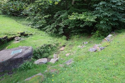
Fairfax Stone State Park is a four-acre site built around a six-ton stone monument that sits at the source of the North Branch Potomac River. The stone displays an informational plaque explaining its historical role in marking colonial land boundaries.
Colonel Peter Jefferson and Thomas Lewis placed the original stone in 1746 to mark the boundary of Lord Fairfax's land grant. This act of surveying shaped how territories were divided during the colonial period and influenced later settlement patterns.
The stone shows how colonial surveyors marked land boundaries and property claims in the early days of America. Visitors can stand at this exact spot and see how these old borders still shape the region today.
The park is open year-round and accessible by a short walking path to the stone monument. Plan to visit during warmer months when the ground is dry and easier to navigate, as the area can be muddy during wetter seasons.
The stone marks the precise point where three counties meet – Preston, Grant, and Tucker – all converging at the same spot. Few places in the region offer this kind of exact boundary intersection where you can stand at the meeting point of three counties.
The community of curious travelers
AroundUs brings together thousands of curated places, local tips, and hidden gems, enriched daily by 60,000 contributors worldwide.