Enable Location

We need your location to show you interesting places around you

Discover nearby places

Find interesting locations and hidden gems around you

Precise directions

Get accurate directions and distances to places

Your location is never shared with other users. It's only used when you tap the location button.

Blow-Me-Down Covered Bridge

Log in to your account

Start exploring — it's free

Trusted by 61,899 travelers worldwide

Continue with Google
Continue with Apple
or

We will send you a code to connect

By continuing, you accept our Terms and Conditions and our Privacy Policy

Check your inbox

We've sent a pincode in your inbox. Please enter the code below.

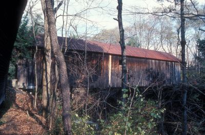
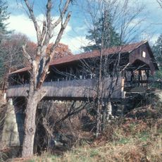
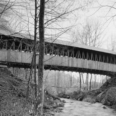
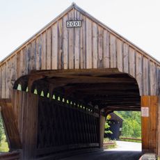
Blow-Me-Down Covered Bridge, Covered bridge in Cornish, New Hampshire, United States.

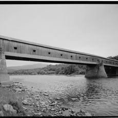
Blow-Me-Down Covered Bridge is a wooden crossing over Blow-Me-Down Brook in Cornish that represents typical 19th-century bridge construction of the region. The structure features wooden walls, a metal-covered roof, and is supported internally by a truss system resting on natural stone foundations.

James Frederick Tasker built the crossing in 1877 to meet a local transportation need, creating a structure that has survived into the modern era. The work was later registered as a protected historic structure, recognizing its value as an example of period engineering methods.

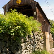
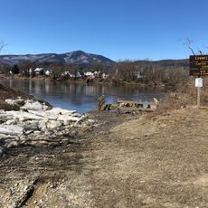
The bridge serves as a functioning part of daily local traffic, allowing people to cross the stream as they have for over a century. It stands as a living reminder of how communities have built and maintained infrastructure across generations.

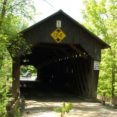
Vehicles can cross the bridge, though weight restrictions apply and should be observed before driving onto it. The structure has undergone significant restoration work and remains accessible year-round, though seasonal conditions may vary.

The foundation rests directly on natural granite rock formations that were leveled with dry-laid stone to support the wooden superstructure. This approach showed practical engineering skill, as existing stone was incorporated into the design rather than being removed or replaced.

The community of curious travelers

AroundUs brings together thousands of curated places, local tips, and hidden gems, enriched daily by 60,000 contributors worldwide.

Start exploring
Location
GPS coordinates
43.51722,-72.37444
Latest update
December 14, 2025 12:22
Around this place
Juniper Hill Farm-Maxwell Evarts House
United States of America

Juniper Hill Farm-Maxwell Evarts House

3.2 km
Cornish–Windsor Covered Bridge
United States of America

Cornish–Windsor Covered Bridge

4.9 km
Saint-Gaudens National Historical Park
United States of America

Saint-Gaudens National Historical Park

1.9 km
American Precision Museum
United States of America

American Precision Museum

4.9 km
Ascutney Mill Dam
United States of America

Ascutney Mill Dam

4.8 km
Salmon P. Chase Birthplace
United States of America

Salmon P. Chase Birthplace

7 km
Cornish Colony Museum
United States of America

Cornish Colony Museum

4.5 km
Dingleton Hill Covered Bridge
United States of America

Dingleton Hill Covered Bridge

5.9 km
Windsor Village Historic District
United States of America

Windsor Village Historic District

4.2 km
Willard Covered Bridge
United States of America

Willard Covered Bridge

8.8 km
Martin's Mill Covered Bridge
United States of America

Martin's Mill Covered Bridge

2.4 km
Cornish Wildlife Management Area
United States of America

Cornish Wildlife Management Area

4.3 km
Kenyon Bridge
United States of America

Kenyon Bridge

5.9 km
Windsor House
United States of America

Windsor House

4 km
Damon Hall
United States of America

Damon Hall

3.4 km
Plainfield Town Hall
United States of America

Plainfield Town Hall

2.6 km
Blow-Me-Down Grange
United States of America

Blow-Me-Down Grange

2.3 km
Fowler-Steele House
United States of America

Fowler-Steele House

3.2 km
David Sumner House
United States of America

David Sumner House

3.2 km
NAMCO Block
United States of America

NAMCO Block

4.8 km
Louis St. Gaudens House and Studio
United States of America

Louis St. Gaudens House and Studio

2.9 km
Ottauquechee River Bridge
United States of America

Ottauquechee River Bridge

9.6 km
Mothers' and Daughters' Club House
United States of America

Mothers' and Daughters' Club House

2.6 km
Saint-Gaudens National Historical Park
United States of America

Saint-Gaudens National Historical Park

1.9 km
Twing Buckman House
United States of America

Twing Buckman House

5.4 km
Old Constitution House
United States of America

Old Constitution House

3.8 km
George H. Stowell Free Library
United States of America

George H. Stowell Free Library

8.1 km
Willard Twin Covered Bridge
United States of America

Willard Twin Covered Bridge

8.7 km
Show the full map
« Blow-Me-Down Covered Bridge - Covered bridge in Cornish, New Hampshire, United States » is provided by Around Us (aroundus.com). Images and texts are derived from Wikimedia project under a Creative Commons license. You are allowed to copy, distribute, and modify copies of this page, under the conditions set by the license, as long as this note is clearly visible.

Discover hidden gems everywhere you go!

From secret cafés to breathtaking viewpoints, skip the crowded tourist spots and find places that match your style. Our app makes it easy with voice search, smart filtering, route optimization, and insider tips from travelers worldwide. Download now for the complete mobile experience.

Around Us App Screenshot

A unique approach to discovering new places

Le Figaro

All the places worth exploring

France Info

A tailor-made excursion in just a few clicks

20 Minutes

Around Us
Travel Guide & Maps
Download

Send to your phone

QR Code
1

Open the camera app on your mobile.

2

Point at the QR code with your camera. A notification will appear.

3

Tap the notification to open the link.