Enable Location

We need your location to show you interesting places around you

Discover nearby places

Find interesting locations and hidden gems around you

Precise directions

Get accurate directions and distances to places

Your location is never shared with other users. It's only used when you tap the location button.

Cornish–Windsor Covered Bridge

Log in to your account

Start exploring — it's free

Trusted by 61,896 travelers worldwide

Continue with Google
Continue with Apple
or

We will send you a code to connect

By continuing, you accept our Terms and Conditions and our Privacy Policy

Check your inbox

We've sent a pincode in your inbox. Please enter the code below.

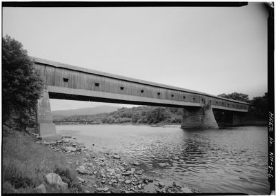
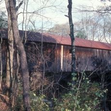
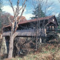
Cornish–Windsor Covered Bridge, Covered bridge in Cornish and Windsor, United States

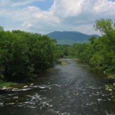
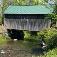
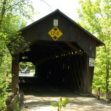
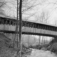
The Cornish-Windsor Covered Bridge is a wooden road bridge that crosses the Connecticut River, connecting Cornish, New Hampshire to Windsor, Vermont. The structure features an intricate lattice pattern in its wooden frame that provides strength across the river's width.

The bridge was built in 1866 by Bela Jenks Fletcher and James Frederick Tasker, originally operating as a toll crossing. New Hampshire took ownership in 1943, eliminating the toll requirement.

The bridge displays construction methods that craftspeople of the 1800s perfected, visible in its wooden lattice design that remains clearly recognizable today. Walking through it, you can see how builders solved the engineering challenges of spanning a wide river with wood alone.

You can enter the bridge from Cornish Toll Bridge Road near Route 12A, with parking available on both the New Hampshire and Vermont sides. Keep in mind that the bridge remains open to vehicle traffic, so pedestrians should stay alert.

From 1866 to 2008, this was the longest wooden covered bridge in the entire United States. The title then passed to another bridge, but it remains noteworthy for its longevity and enduring appeal.

The community of curious travelers

AroundUs brings together thousands of curated places, local tips, and hidden gems, enriched daily by 60,000 contributors worldwide.

Start exploring
Location
Location
Inception
1866
Made from material
wood
GPS coordinates
43.47361,-72.38389
Latest update
December 8, 2025 13:43
Around this place
Juniper Hill Farm-Maxwell Evarts House
United States of America

Juniper Hill Farm-Maxwell Evarts House

2.2 km
Mount Ascutney
United States of America

Mount Ascutney

6.6 km
Saint-Gaudens National Historical Park
United States of America

Saint-Gaudens National Historical Park

3.3 km
American Precision Museum
United States of America

American Precision Museum

470 m
Ascutney Mill Dam
United States of America

Ascutney Mill Dam

1 km
Blow-Me-Down Covered Bridge
United States of America

Blow-Me-Down Covered Bridge

4.9 km
Salmon P. Chase Birthplace
United States of America

Salmon P. Chase Birthplace

2.1 km
Cornish Colony Museum
United States of America

Cornish Colony Museum

523 m
Ascutney State Park
United States of America

Ascutney State Park

5.7 km
Union Episcopal Church
United States of America

Union Episcopal Church

10 km
Dingleton Hill Covered Bridge
United States of America

Dingleton Hill Covered Bridge

1.6 km
Windsor Village Historic District
United States of America

Windsor Village Historic District

812 m
Bowers Covered Bridge
United States of America

Bowers Covered Bridge

8.8 km
Martin's Mill Covered Bridge
United States of America

Martin's Mill Covered Bridge

6.6 km
Cornish Wildlife Management Area
United States of America

Cornish Wildlife Management Area

745 m
Kenyon Bridge
United States of America

Kenyon Bridge

2.8 km
Windsor House
United States of America

Windsor House

980 m
Damon Hall
United States of America

Damon Hall

7.7 km
Plainfield Town Hall
United States of America

Plainfield Town Hall

7.3 km
Blow-Me-Down Grange
United States of America

Blow-Me-Down Grange

7 km
Fowler-Steele House
United States of America

Fowler-Steele House

1.8 km
David Sumner House
United States of America

David Sumner House

7.5 km
NAMCO Block
United States of America

NAMCO Block

519 m
Louis St. Gaudens House and Studio
United States of America

Louis St. Gaudens House and Studio

4.2 km
Mothers' and Daughters' Club House
United States of America

Mothers' and Daughters' Club House

7.3 km
Saint-Gaudens National Historical Park
United States of America

Saint-Gaudens National Historical Park

3.2 km
Twing Buckman House
United States of America

Twing Buckman House

637 m
Old Constitution House
United States of America

Old Constitution House

1.2 km
Show the full map
« Cornish–Windsor Covered Bridge - Covered bridge in Cornish and Windsor, United States » is provided by Around Us (aroundus.com). Images and texts are derived from Wikimedia project under a Creative Commons license. You are allowed to copy, distribute, and modify copies of this page, under the conditions set by the license, as long as this note is clearly visible.

Discover hidden gems everywhere you go!

From secret cafés to breathtaking viewpoints, skip the crowded tourist spots and find places that match your style. Our app makes it easy with voice search, smart filtering, route optimization, and insider tips from travelers worldwide. Download now for the complete mobile experience.

Around Us App Screenshot

A unique approach to discovering new places

Le Figaro

All the places worth exploring

France Info

A tailor-made excursion in just a few clicks

20 Minutes

Around Us
Travel Guide & Maps
Download

Send to your phone

QR Code
1

Open the camera app on your mobile.

2

Point at the QR code with your camera. A notification will appear.

3

Tap the notification to open the link.