Enable Location

We need your location to show you interesting places around you

Discover nearby places

Find interesting locations and hidden gems around you

Precise directions

Get accurate directions and distances to places

Your location is never shared with other users. It's only used when you tap the location button.

Borough Hall of the Borough of Waynesboro

Log in to your account

Start exploring — it's free

Trusted by 61,773 travelers worldwide

Continue with Google
Continue with Apple
or

We will send you a code to connect

By continuing, you accept our Terms and Conditions and our Privacy Policy

Check your inbox

We've sent a pincode in your inbox. Please enter the code below.

Borough Hall of the Borough of Waynesboro

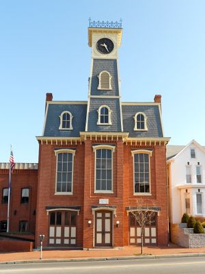
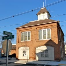
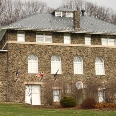
Borough Hall of the Borough of Waynesboro, Municipal building in Waynesboro, United States.

Description

Borough Hall of the Borough of Waynesboro is a municipal building displaying Second Empire design, recognizable by its mansard roof, ornamental cornices, and evenly spaced windows across multiple levels. The facade exemplifies the architectural sophistication characteristic of this European style adapted to American civic buildings.

History

The building was added to the National Register of Historic Places in recognition of its architectural importance and its long role in local administration. This designation reflects how it has shaped the development of Waynesboro as a community.

Culture

The building serves as a gathering place where residents conduct local affairs and civic matters. Its role in community life reflects the everyday workings of small-town government and public participation.

Practical

The hall sits in downtown Waynesboro and serves as the administrative center for residents seeking services or information. Visitors should plan to arrive during regular business hours when municipal offices are staffed and open to the public.

Did you know?

The structure demonstrates how 19th-century European architectural fashions found expression in small American towns. Its Second Empire style was typical for civic centers of that era seeking to project prosperity and community pride.

Location
Architectural style
Second Empire architecture in Europe
GPS coordinates
39.75500,-77.57670
Latest update
December 14, 2025 18:42

AroundUs brings together thousands of curated places, local tips, and hidden gems, enriched daily by 60,000 contributors worldwide. Discover all places nearby (Pennsylvania).

Around this place
Quirauk Mountain
United States of America

Quirauk Mountain

8.5 km
Alexander Hamilton House
United States of America

Alexander Hamilton House

27 m
Victor Cullen Center, Old Administration Building
United States of America

Victor Cullen Center, Old Administration Building

11.3 km
Welty's Mill Bridge
United States of America

Welty's Mill Bridge

2 km
Monterey Historic District
United States of America

Monterey Historic District

9.4 km
Long Meadows
United States of America

Long Meadows

11.5 km
Royer-Nicodemus House and Farm
United States of America

Royer-Nicodemus House and Farm

1.8 km
Brightwood
United States of America

Brightwood

10.7 km
Greencastle Historic District
United States of America

Greencastle Historic District

13.2 km
Old Forge Farm
United States of America

Old Forge Farm

11.6 km
Victor Cullen School Power House
United States of America

Victor Cullen School Power House

10.8 km
Bell-Varner House
United States of America

Bell-Varner House

10.1 km
Dorsey-Palmer House
United States of America

Dorsey-Palmer House

12.6 km
Leitersburg Historic District
United States of America

Leitersburg Historic District

7.7 km
Jeremiah Burns Farm
United States of America

Jeremiah Burns Farm

4.2 km
Joseph J. Oller House
United States of America

Joseph J. Oller House

471 m
Paradise Manor
United States of America

Paradise Manor

12.4 km
Lehman's Mill Historic District
United States of America

Lehman's Mill Historic District

9.8 km
Lantz-Zeigler House
United States of America

Lantz-Zeigler House

9 km
Tipahato
United States of America

Tipahato

9.7 km
Handycraft Farmstead
United States of America

Handycraft Farmstead

3.8 km
Rockledge
United States of America

Rockledge

8 km
Rohrer House
United States of America

Rohrer House

13.1 km
Mitchell-Shook House
United States of America

Mitchell-Shook House

12.9 km
Good-Hartle Farm
United States of America

Good-Hartle Farm

9.3 km
Renfrew Museum and Park
United States of America

Renfrew Museum and Park

1.9 km
Mont Alto State Park
United States of America

Mont Alto State Park

9.9 km
Raven Rock Shelter
United States of America

Raven Rock Shelter

9.9 km
Show the full map
« Borough Hall of the Borough of Waynesboro - Municipal building in Waynesboro, United States » is provided by Around Us (aroundus.com). Images and texts are derived from Wikimedia project under a Creative Commons license. You are allowed to copy, distribute, and modify copies of this page, under the conditions set by the license, as long as this note is clearly visible.

Discover hidden gems everywhere you go!

From secret cafés to breathtaking viewpoints, skip the crowded tourist spots and find places that match your style. Our app makes it easy with voice search, smart filtering, route optimization, and insider tips from travelers worldwide. Download now for the complete mobile experience.

Around Us App Screenshot

A unique approach to discovering new places

Le Figaro

All the places worth exploring

France Info

A tailor-made excursion in just a few clicks

20 Minutes

Around Us
Travel Guide & Maps
Download

Send to your phone

QR Code
1

Open the camera app on your mobile.

2

Point at the QR code with your camera. A notification will appear.

3

Tap the notification to open the link.