Victor Cullen Center, Old Administration Building

Log in to your account

AroundUs is a community-driven map of interesting places, built by curious explorers like you. It grows with every review, story, and photo you share.
Connect to save your favorite spots, contribute locations, and create personalized routes.
Continue with Google
Continue with Apple
Continue with X
Continue with Facebook
Continue with email
By continuing, you accept our Terms and Conditions and our Privacy Policy
Create an account

Victor Cullen Center, Old Administration Building

Add to collection
Map
Suggest a change
Share

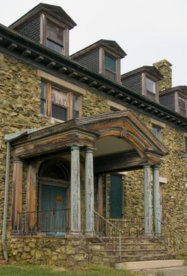
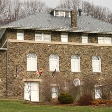
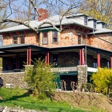
Victor Cullen Center, Old Administration Building, Historic administrative building in Sabillasville, Maryland.

Victor Cullen Center, the former administrative building, is a brick structure in Colonial Revival style with four substantial stone chimneys positioned symmetrically at each gable end. The structure showcases a balanced facade and sturdy craftsmanship typical of medical facilities from this era.

The building opened in 1907 as part of Maryland's first government-sponsored facility dedicated to treating tuberculosis. It marked an important shift in how the state approached public health for a disease that was then widely fatal.

The building reflects early 1900s views on how to design spaces for healing and patient care in a medical setting. Its symmetrical layout and sturdy stone construction conveyed a sense of order and permanence that reassured visitors.

The building is located in Sabillasville in Frederick County and is visible from the road, though it sits on a larger grounds. Best access is via the local roadway, and visitors should request permission if visiting private property.

The building was part of a pioneering medical facility treating tuberculosis patients when the disease seemed unstoppable. The architectural care taken in its design reflected the belief that healing could be supported through the physical environment itself.

Location: Maryland

Architects: Wyatt & Nolting

Architectural style: Colonial Revival architecture

GPS coordinates: 39.71110,-77.45720

Latest update: December 14, 2025 13:06

Photos
Around this place
Catoctin Mountain
United States of America

Catoctin Mountain

7 km
National Shrine of St. Elizabeth Ann Seton
United States of America

National Shrine of St. Elizabeth Ann Seton

10.9 km
Quirauk Mountain
United States of America

Quirauk Mountain

5 km
National Fallen Firefighters Memorial
United States of America

National Fallen Firefighters Memorial

11.4 km
Camp Misty Mount Historic District
United States of America

Camp Misty Mount Historic District

7.7 km
Alexander Hamilton House
United States of America

Alexander Hamilton House

11.3 km
Camp Greentop Historic District
United States of America

Camp Greentop Historic District

7.7 km
Roddy Road Covered Bridge
United States of America

Roddy Road Covered Bridge

9.5 km
Jacks Mountain Covered Bridge
United States of America

Jacks Mountain Covered Bridge

8.6 km
Welty's Mill Bridge
United States of America

Welty's Mill Bridge

10.3 km
Monterey Historic District
United States of America

Monterey Historic District

3 km
Borough Hall of the Borough of Waynesboro
United States of America

Borough Hall of the Borough of Waynesboro

11.3 km
Royer-Nicodemus House and Farm
United States of America

Royer-Nicodemus House and Farm

9.7 km
Emmitsburg Historic District
United States of America

Emmitsburg Historic District

11.1 km
Victor Cullen School Power House
United States of America

Victor Cullen School Power House

545 m
Jeremiah Burns Farm
United States of America

Jeremiah Burns Farm

8.7 km
St. Euphemia's School and Sisters' House
United States of America

St. Euphemia's School and Sisters' House

11.3 km
Tipahato
United States of America

Tipahato

2.7 km
Handycraft Farmstead
United States of America

Handycraft Farmstead

8.8 km
Renfrew Museum and Park
United States of America

Renfrew Museum and Park

9.5 km
Catoctin Mountain Park Visitor Center
United States of America

Catoctin Mountain Park Visitor Center

8.6 km
Chimney Rock
United States of America

Chimney Rock

9.3 km
Camp Round Meadow
United States of America

Camp Round Meadow

7.8 km
Camp Greentop
United States of America

Camp Greentop

7.6 km
Mt. Moriah Lutheran Church
United States of America

Mt. Moriah Lutheran Church

7.8 km
Catoctin Mountain Park Resource Management Office
United States of America

Catoctin Mountain Park Resource Management Office

7.7 km
Raven Rock Shelter
United States of America

Raven Rock Shelter

7.5 km
Hunting Creek Lake
United States of America

Hunting Creek Lake

9.5 km
Show the full map
Reviews

Visited this place? Tap the stars to rate it and share your experience / photos with the community! Try now! You can cancel it anytime.

« Victor Cullen Center, Old Administration Building - Historic administrative building in Sabillasville, Maryland » is provided by Around Us (aroundus.com). Images and texts are derived from Wikimedia project under a Creative Commons license. You are allowed to copy, distribute, and modify copies of this page, under the conditions set by the license, as long as this note is clearly visible.

Discover hidden gems everywhere you go!

From secret cafés to breathtaking viewpoints, skip the crowded tourist spots and find places that match your style. Our app makes it easy with voice search, smart filtering, route optimization, and insider tips from travelers worldwide. Download now for the complete mobile experience.

Around Us App Screenshot

A unique approach to discovering new places

Le Figaro

All the places worth exploring

France Info

A tailor-made excursion in just a few clicks

20 Minutes