Jacks Mountain Covered Bridge

Log in to your account

AroundUs is a community-driven map of interesting places, built by curious explorers like you. It grows with every review, story, and photo you share.
Connect to save your favorite spots, contribute locations, and create personalized routes.
Continue with Google
Continue with Apple
Continue with X
Continue with Facebook
Continue with email
By continuing, you accept our Terms and Conditions and our Privacy Policy
Create an account
Add to collection
Map
Suggest a change
Share

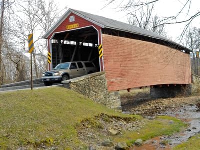
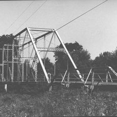
Jacks Mountain Covered Bridge, Covered bridge near Iron Springs, United States.

Jacks Mountain Covered Bridge is a covered structure that crosses Tom's Creek using horizontal wooden siding and a tin-covered gable roof. The structure employs a Burr truss system, which is a strong construction method that distributes weight evenly and allows the bridge to last a long time.

Joseph Smith designed and built this bridge in 1890 using the Burr truss method, which was a modern approach for its time. In 1980, it received recognition and was added to the National Register of Historic Places.

The bridge belongs to a group of covered structures scattered across Adams County and its neighboring areas that represent how people once moved through the region. Walking across it shows the simple engineering approach that communities relied on for their daily travel needs.

Access to the bridge is along Legislative Route 01053 in Hamiltonban Township, southwest of Fairfield in Adams County, where parking space is available nearby. The best time to visit is late summer or early fall, when the weather is mild and the surrounding landscape looks especially pleasant.

The wooden structure still shows original engineering components from the 1800s, showing how builders crossed rivers without modern machinery. Many visitors miss the fact that the Burr truss method is particularly well preserved here, and you can clearly see the individual connected wooden pieces that hold the bridge together.

Location: Pennsylvania

GPS coordinates: 39.76690,-77.38690

Latest update: December 14, 2025 17:02

Photos
Around this place
Eisenhower National Historic Site
United States of America

Eisenhower National Historic Site

11 km
The Angle
United States of America

The Angle

13.9 km
Sachs Covered Bridge
United States of America

Sachs Covered Bridge

10.1 km
National Shrine of St. Elizabeth Ann Seton
United States of America

National Shrine of St. Elizabeth Ann Seton

9.1 km
The Pennsylvania State Memorial
United States of America

The Pennsylvania State Memorial

13.7 km
St. Joseph's College and Mother Seton Shrine
United States of America

St. Joseph's College and Mother Seton Shrine

9.8 km
Quirauk Mountain
United States of America

Quirauk Mountain

13.3 km
National Fallen Firefighters Memorial
United States of America

National Fallen Firefighters Memorial

9.6 km
Virginia Monument
United States of America

Virginia Monument

12.8 km
Cashtown Inn
United States of America

Cashtown Inn

13.3 km
North Carolina Monument
United States of America

North Carolina Monument

13.2 km
11th Mississippi Infantry Monument
United States of America

11th Mississippi Infantry Monument

13.3 km
Victor Cullen Center, Old Administration Building
United States of America

Victor Cullen Center, Old Administration Building

8.6 km
Alabama State Monument
United States of America

Alabama State Monument

11.6 km
Monterey Historic District
United States of America

Monterey Historic District

7.8 km
Winfield Scott Hancock
United States of America

Winfield Scott Hancock

13.7 km
Fairfield Historic District
United States of America

Fairfield Historic District

3.3 km
Emmitsburg Historic District
United States of America

Emmitsburg Historic District

8.5 km
Fourpoints Bridge
United States of America

Fourpoints Bridge

12.9 km
Victor Cullen School Power House
United States of America

Victor Cullen School Power House

8.7 km
Bridge in Cumberland Township
United States of America

Bridge in Cumberland Township

8.8 km
Jeremiah Burns Farm
United States of America

Jeremiah Burns Farm

12.2 km
St. Euphemia's School and Sisters' House
United States of America

St. Euphemia's School and Sisters' House

8.7 km
Tipahato
United States of America

Tipahato

11.1 km
Horner House and Barn
United States of America

Horner House and Barn

12.5 km
Handycraft Farmstead
United States of America

Handycraft Farmstead

12.6 km
Lower Marsh Creek Presbyterian Church
United States of America

Lower Marsh Creek Presbyterian Church

6.8 km
Jacob and Juliana Middlekauff House
United States of America

Jacob and Juliana Middlekauff House

12.4 km
Show the full map
Reviews

Visited this place? Tap the stars to rate it and share your experience / photos with the community! Try now! You can cancel it anytime.

« Jacks Mountain Covered Bridge - Covered bridge near Iron Springs, United States » is provided by Around Us (aroundus.com). Images and texts are derived from Wikimedia project under a Creative Commons license. You are allowed to copy, distribute, and modify copies of this page, under the conditions set by the license, as long as this note is clearly visible.

Discover hidden gems everywhere you go!

From secret cafés to breathtaking viewpoints, skip the crowded tourist spots and find places that match your style. Our app makes it easy with voice search, smart filtering, route optimization, and insider tips from travelers worldwide. Download now for the complete mobile experience.

Around Us App Screenshot

A unique approach to discovering new places

Le Figaro

All the places worth exploring

France Info

A tailor-made excursion in just a few clicks

20 Minutes