Sachs Covered Bridge

Log in to your account

AroundUs is a community-driven map of interesting places, built by curious explorers like you. It grows with every review, story, and photo you share.
Connect to save your favorite spots, contribute locations, and create personalized routes.
Continue with Google
Continue with Apple
Continue with X
Continue with Facebook
Continue with email
By continuing, you accept our Terms and Conditions and our Privacy Policy
Create an account
Add to collection
Map
Suggest a change
Share

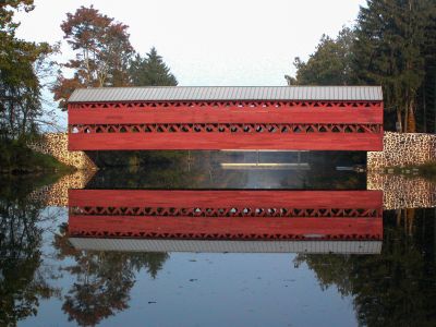
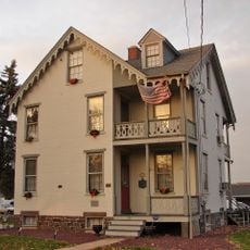
Sachs Covered Bridge, Covered bridge in Adams County, Pennsylvania, United States

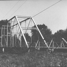
Sachs Covered Bridge is a wooden crossing over Marsh Creek in Adams County, Pennsylvania, built with a classical Town truss design where beams crisscross to form a lattice pattern. The structure spans about 100 feet of water and displays the characteristic red wood exterior and enclosed design typical of its era.

The bridge was built in 1854 and served as a crucial crossing when Union and Confederate armies passed through during the Battle of Gettysburg in 1863. It survived this conflict and was later recognized for its historical importance, solidifying its place in regional heritage.

Named after its original landowner, the structure stands as a working example of 19th-century craftsmanship that visitors can experience firsthand. The red wooden walls and traditional design remain part of the local landscape's character, connecting people to an era when such crossings shaped daily life.

Access is available on foot, and visitors should be aware that water levels can affect accessibility during certain seasons. The wooden surfaces can become slippery in wet conditions, so caution is advised when crossing in damp weather.

The crossing suffered severe damage from flooding in the mid-1990s, but a major restoration effort brought it back to working condition for pedestrian use. This recovery demonstrates how much the community valued the structure and the effort invested in preserving such historical works.

Location: Pennsylvania

GPS coordinates: 39.79740,-77.27610

Latest update: December 7, 2025 20:49

Photos
Around this place
High-water mark of the Confederacy
United States of America

High-water mark of the Confederacy

3.8 km
Eisenhower National Historic Site
United States of America

Eisenhower National Historic Site

1.2 km
The Angle
United States of America

The Angle

3.8 km
Gettysburg National Military Park Museum and Visitor Center
United States of America

Gettysburg National Military Park Museum and Visitor Center

4.6 km
The Pennsylvania State Memorial
United States of America

The Pennsylvania State Memorial

3.7 km
Gettysburg National Tower
United States of America

Gettysburg National Tower

4.4 km
Soldiers' National Monument
United States of America

Soldiers' National Monument

4.6 km
Evergreen Cemetery
United States of America

Evergreen Cemetery

4.8 km
Gettysburg Battlefield Historic District
United States of America

Gettysburg Battlefield Historic District

4.5 km
72nd Pennsylvania Infantry Monument
United States of America

72nd Pennsylvania Infantry Monument

3.9 km
McPherson Ridge
United States of America

McPherson Ridge

5.2 km
Friend to Friend Masonic Memorial
United States of America

Friend to Friend Masonic Memorial

4.6 km
High Water Mark of the Rebellion Monument
United States of America

High Water Mark of the Rebellion Monument

3.8 km
Virginia Monument
United States of America

Virginia Monument

2.9 km
North Carolina Monument
United States of America

North Carolina Monument

3.4 km
Adams County Courthouse
United States of America

Adams County Courthouse

5.2 km
Evergreen Cemetery gatehouse
United States of America

Evergreen Cemetery gatehouse

4.8 km
11th Mississippi Infantry Monument
United States of America

11th Mississippi Infantry Monument

3.5 km
Schmucker Hall
United States of America

Schmucker Hall

4.7 km
Gettysburg National Museum
United States of America

Gettysburg National Museum

4.3 km
United States of America

Gettysburg Rostrum

4.4 km
Alabama State Monument
United States of America

Alabama State Monument

2.2 km
New York State Monument
United States of America

New York State Monument

4.7 km
Winfield Scott Hancock
United States of America

Winfield Scott Hancock

3.7 km
Sheads House
United States of America

Sheads House

5 km
Bridge in Cumberland Township
United States of America

Bridge in Cumberland Township

4.5 km
David Wills House
United States of America

David Wills House

5.4 km
Lower Marsh Creek Presbyterian Church
United States of America

Lower Marsh Creek Presbyterian Church

5.1 km
Show the full map
Reviews

Visited this place? Tap the stars to rate it and share your experience / photos with the community! Try now! You can cancel it anytime.

« Sachs Covered Bridge - Covered bridge in Adams County, Pennsylvania, United States » is provided by Around Us (aroundus.com). Images and texts are derived from Wikimedia project under a Creative Commons license. You are allowed to copy, distribute, and modify copies of this page, under the conditions set by the license, as long as this note is clearly visible.

Discover hidden gems everywhere you go!

From secret cafés to breathtaking viewpoints, skip the crowded tourist spots and find places that match your style. Our app makes it easy with voice search, smart filtering, route optimization, and insider tips from travelers worldwide. Download now for the complete mobile experience.

Around Us App Screenshot

A unique approach to discovering new places

Le Figaro

All the places worth exploring

France Info

A tailor-made excursion in just a few clicks

20 Minutes